We have added a variety of new and enhanced features to ArcGIS Roads and Highways at the ArcGIS Pro 3.1 and ArcGIS Enterprise 11.1 releases, including expanded event editing capabilities in ArcGIS Pro, tools to support measure translation on the fly, and enhancements to linear referencing system (LRS) intersections to provide additional information about intersecting routes. Furthermore, Roads and Highways capabilities have been added to the ArcGIS Enterprise sync service to enable disconnected LRS event collection and updates in the field.
Event Editing in ArcGIS Pro
The following new event editing capabilities are now available in ArcGIS Roads and Highways in ArcGIS Pro.
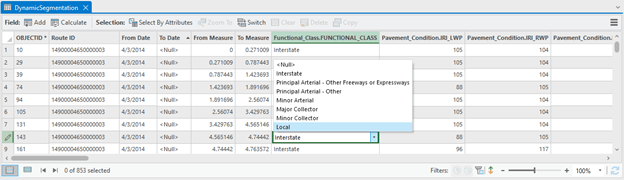
Editable Dynamic Segmentation
The Dynamic Segmentation tool allows you to dynamically segment multiple LRS events and visualize them in the map and in a table. The table is editable, allowing you to edit the attributes in the fields within the table. The resulting changes from those edits will be stored in the LRS event record(s) that contributed to the dynamic segmentation and are reflected in the updated dynamic segmentation table.
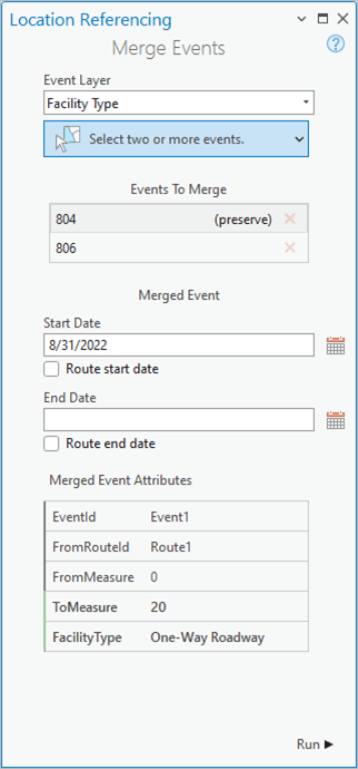
Merge Events
As roadway characteristics change over time, there are cases when the attributes of adjacent events are now the same and can be merged into a single event record to streamline the management of event data along that road. The merge events tool supports this workflow of two adjacent LRS event records being merged into a single record.
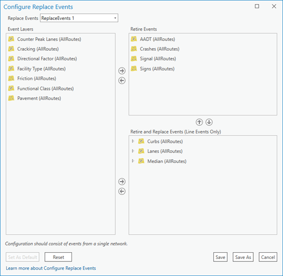
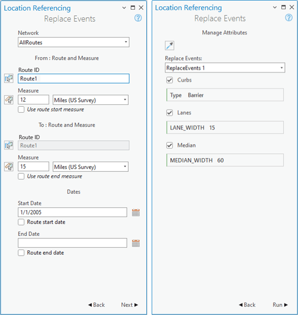
Event Replacement
The event replacement tool allows you to configure multiple LRS event layers that can be either retired or retired then replaced when a road is updated without a change in measure or geometry, such as during a repaving or widening project. Events configured to retire will retire if they’re located within the section of road being replaced. Events configured to retire and replace will be retired on the date of the replacement and a new record (with updated attributes) will be created.
In addition, the following enhancements to existing event editing tools within ArcGIS Pro have been added.
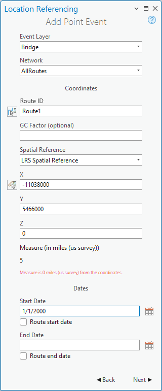
Coordinate and Intersection Offset input methods
GIS professionals are responsible for getting event data (which can be in a variety of formats) into ArcGIS Roads and Highways. While route and measure may be the most common format, this data can also come in as coordinates or as offset from other features like intersections. The Add Point and Line Event tools in ArcGIS Pro have been enhanced to support these additional input methods for new event data coming into the LRS.
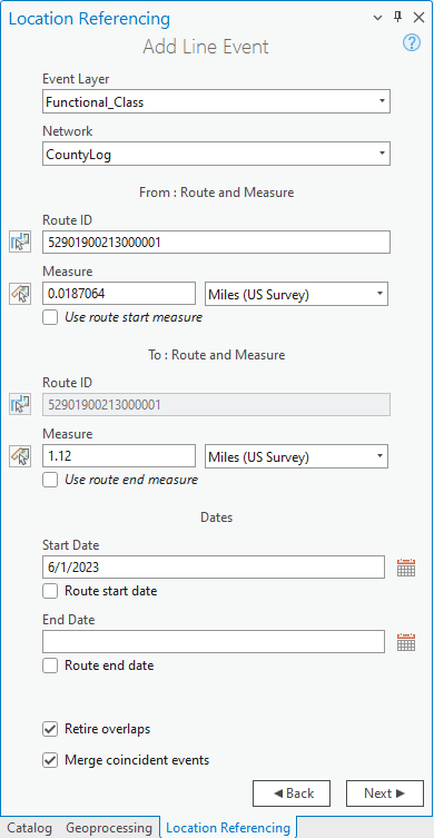
Retire Overlaps and Merge Coincident options
The Add Line Event tools have been enhanced to support options to retire overlaps and merge coincident events. Retire Overlaps will automatically retire existing events that would overlap in time and location with any newly added event created by the tool. Merge Coincident will consider any adjacent events that share the same attributes as the event being added and will automatically merge them into a single event to prevent unnecessary segmentation of event data.
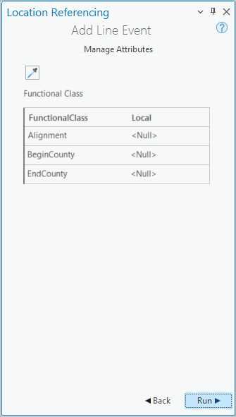
Eyedropper tool to copy attributes from adjacent events
When adding multiple point or line events to a route, many of the attributes could be the same as on other event records that already exist on the road. When adding events that have multiple attributes, you can use the eyedropper tool to copy attributes from another event on the map to simplify the entry of multiple attributes.
Additional ArcGIS Pro tools
We’ve added new tools to improve the user experience going between Route Name and RouteID fields as well as a new tool that supports renaming routes within the system.
Translate tool
The new translate tool allows you to quickly translate measures between routes that are coincident or intersections within any LRS Network. Additionally, if utilizing a line network, the tool will support translating between RouteID and Route Name or LineID and Line Name fields.
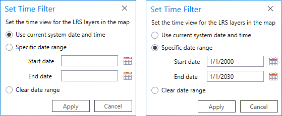
Set Time Filter
If you don’t need to take advantage of all the ArcGIS Pro time capabilities on the Time ribbon, the Set Time Filter tool on the Location Referencing ribbon allows for easy configuration of the time view of LRS layers in the map. You can set the time on the map to a specific date (including the current date) as well as any range of time.
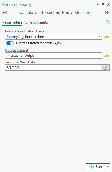
Calculate Intersecting Route Measures geoprocessing tool
The Calculate Intersecting Route Measures tool provides additional information about the routes that are a part of LRS Intersections. The tool outputs all the routes that are part of an intersection and includes the measure for each of those routes at the intersecting location.
ArcGIS Enterprise
LRS support in the sync service capability
LRS support has been added to the sync service capability with the ArcGIS Enterprise 11.1 release. This allows LRS events to be taken offline for collection and updating using ArcGIS Field Maps. Once you finishes the collection/updating of events and return to connectivity, you can sync the events back into the current version of the LRS using the sync button in Field Maps. ArcGIS Roads and Highways will ensure that any time slicing or event behaviors are applied to events that were collected against routes that changed in the LRS while offline collection/update was completed.


Article Discussion: