There are many reasons to use ArcGIS Pro. Maybe you need 64-bit geoprocessing or lightning fast mapping to get your job done. Perhaps your project requires multiple layouts and maps, or you wanted to finally step into 3D GIS. Pro’s full integration with ArcGIS Online and ArcGIS Enterprise also provides some amazing possibilities.
Whatever your reason, the first time you opened ArcGIS Pro you were confronted with something different – a ribbon-based application with a contextual user experience. It doesn’t look anything like ArcMap. You might be asking: “Where are all the buttons I am familiar with, and what is this ribbon thing?” Maybe you’ve used a ribbon before in a word processing, spreadsheet, or email application, but never with GIS.
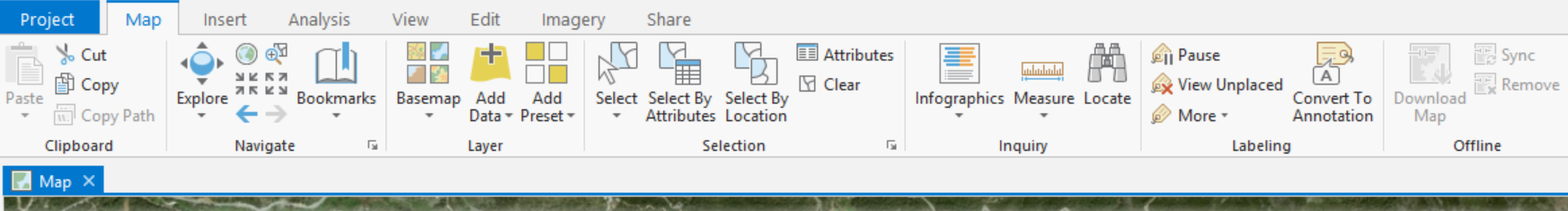
ArcGIS Pro ribbon
The ribbon is the primary interface for working in ArcGIS Pro. Hundreds of essential GIS commands and tools (buttons) are located in contextual ribbon tabs associated with whatever view you have active.
Looking at a map? You are presented with ribbon tabs for:
- Navigating, adding data, and selecting features (Map tab)
- Performing spatial analysis (Analysis tab)
- Editing and creating new features in your map (Edit tab)
- Packaging or publishing a map layer or the map itself (Share tab)
- And more.
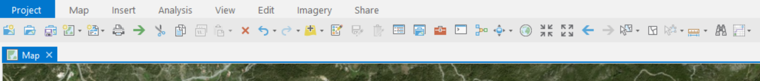
ArcMap toolbars
This is obviously much different from how buttons are laid out in ArcMap. ArcMap’s tools and commands are on a number of toolbars, including:
- The Standard toolbar has a wide range of commands, like Open and Save map document, Cut, Copy, and Paste, Undo, Redo, Add Data, Editor, etc.
- The Tools toolbar provides interactive tools to Zoom In, Zoom Out, Pan, zoom to Full Extent, Select features, Clear Selection, Identify, Measure, and Find.
- And roughly 40 other toolbars for every GIS command or tool in the book.

After years of working with a full-featured professional software like ArcMap, the toolbars, buttons, and their locations may be second nature to you. I can definitely say you are not alone.
The learning curve
I’ve observed a pattern with those who have downloaded ArcGIS Pro to start using it for their work or just to see what it’s all about. A gradual but often quick progression that can start with some frustration at not knowing where to find a command or tool. Typically after a few days a proficiency starts to develop, but still some jumping between ribbon tabs might occur to find a less frequently-used button. Finally, after a few weeks, mastery of the ribbon is attained as you have a mental map of all the commands and tools needed to perform your job.
Even if you are an experienced ArcGIS Pro user, you might wish that your most frequently-used commands would be in one convenient location. My colleague Hannah Deindorfer recently wrote about customizing the UI of ArcGIS Pro. I think two of these options for customization might help you if you are having difficulty adjusting to ArcGIS Pro or have trouble locating buttons in the ribbon:
- In the Project > Options > Customize the Ribbon window, you can move any command or tool to any ribbon location you prefer. You can create new ribbon tabs and groups, or even rename the existing tabs and groups.
- Any command or tool on the ribbon can be added to the Quick Access Toolbar (QAT). By default, the QAT includes the commands: New project, Open project, and Save project, as well as Undo and Redo. This toolbar is easy to customize so your favorite commands and tools are in a convenient and centralized location in the UI.
Making an ArcMap-style toolbar for ArcGIS Pro
I’ve taken customization of Pro’s QAT a few steps further. In addition to adding frequently-used commands and tools to the QAT, I minimize the ribbon. You can also move the QAT below the ribbon tabs. And just like that, you’ve got a familiar, click-reducing, productivity-enhancing toolbar in ArcGIS Pro.
….Yes, I did go through the process of recreating ArcMap’s Standard and Tools toolbars using the QAT in ArcGIS Pro (download user.config file).
While it’s a very close match between ArcMap’s standard toolbars and this customized Pro QAT, there are a few differences worth discussing and understanding.
Pro projects
ArcGIS Pro is a project-based application, so the first buttons are New project, Open project, and Save project. You do not work with map documents like you did in ArcMap. However, I’ve added the New Map and New Layout commands after the project commands, since adding maps and layouts is common for almost all projects.
Printing and exporting maps
In addition to the command to Print Map, there is a command to Export Map to File, like a .pdf, .svg, or .jpg. ArcGIS Pro is great at exporting high-quality .pdfs.
Copy data paths
ArcGIS Pro 2.1 has a Copy Path command that is extremely useful, so it is on the QAT toolbar despite no such button in ArcMap. Select some item in the Catalog pane, then click this button to copy its path.
Delete
The Delete button only works on selected features in the map, as there are no map graphics or free text in the latest version of ArcGIS Pro.
Map scale
Map Scale is not on a ribbon command so cannot be added to the QAT. But the scale control is always available in the status bar below the map.
Editing
The ArcMap Standard toolbar has a button to open the Editor toolbar which has commands to Start Editing and Stop Editing, among many others. There is no Start Editing or StopEditing in ArcGIS Pro, as edit sessions are started on demand, and stopped when you Save or DiscardEdits. The closest capability for the Pro QAT is the Create Features pane. Save Edits and DiscardEdits were added to the toolbar for convenience.
Zoom
There are no Zoom In or Zoom Out rectangle tools in the latest version of ArcGIS Pro. Navigation and zooming can be accomplished using the mouse or keyboard shortcuts while using the Explore tool, or using the new on-screen Navigator control.
Select elements
The Select Elements tool can only be used with layout elements, as there are no graphics or free text in the latest version of ArcGIS Pro.
Explore tool
The Identify, Hyperlink, and HTMLPopup tools in ArcMap have been combined into the Explore tool in ArcGIS Pro.
Locate
The Search command opens the Locate pane where you can search for place names or addresses, attribute values in your configured layers, and latitude (y) – longitude (x) pairs. This combines ArcMap’s Find and Go To XY commands.
Network analysis
There is no dedicated Find Routes button or dialog like ArcMap has. Instead there is a Network Analysis button with a menu containing several commands for network analysis. This includes routing and service areas (drive-time buffers), among others.
Time slider
In ArcGIS Pro the Time Slider is not available as a ribbon button. Rather, it is enabled by configuring the time properties of a layer in your map.
Overview map and multiple views
There is no Create Viewer Window command available in Pro. Link multiple map views to get secondary views of the same map layers.
Toolbar position
The ArcGIS Pro QAT can only be positioned above or below the ribbon. You cannot tear the QAT off to float over the application, or dock it in a different location.
I hope this ArcGIS Pro hack configuration might help a few people out there to be more productive in their work.

Actually the heavy reliance on the ribbon for tool access is fundamental flaw in the new UI. ArcMaps floating toolbars enabled one click to access any tool. Now every action requires a minimum of two clicks. Even when in the general context of the toolset itself (geoprocessing, labelling, editing etc). The other issue is that most tools are unresponsive on the first click in the map space.
Take for example georeferencing, in most instance you need about 4 tools on the geoprocessing toolbar, but the ribbon runs off and hides everytime you select a tool, so a tool switch on the geoprocessing ribbon is always at least a 2 click event. Then when adding a control point, Pro ignores the first click and so you end up creating the from point as the to point and have to back track. … why?
The job always required a bit of swiping and transparency adjustments as well especially with old maps and charts. There is also panning and zooming, so there’s about 8 – 12 tools required to get the job done, and yet the ArcGIS pro UI is designed to keep them constantly hidden from access.
This isn’t rocket science guys. Tool usage is a significant characteristic of our species. Take a trip to your local hardware store and there’s usually an entire section dedicated to tools belts: cleverly designed outfitting specifically for enabling quick access to the toolset for any job.
Have your engineers never performed a manual task like hanging a door, or building a wonky table? Screwdriver, Tech-gun, hammer, chisel, saw, drill bits, square. All in visual scanning range and within hands reach.
That requirement will never change for our species.
Its no different for software, but ArcGIS Pro’s approach to tools is storage, not access. ESRI are focusing too much on making everything look organised and packed away, so everything looks neat. In doing so, this denies the visual cortex of the software operator the ability to play its very important role in in the interaction with the toolsets.
There is significant research into the importance of the visual cortex in processing spatial information, and which ESRI have paid attention to in relation to map interpretation and spatial processing in the map space. Unfortunately this has not been applied to the controls, so the operator is mostly blind and must rely on memory and mental maps to locate a tool, rather than being able to employ the visual cortex’s processing power to scan and locate, and thus operate efficiently.
I work in a small team of 5, handling 800 – 1200 cartographic jobs per annum, and producing upward of 4000 individual maps each year. We’ve been using Pro for about 12 months, and generally the consensus is that its far too inefficient to be considered as a reasonable choice for out purposes.
The UI is not intuitive, and I’ll be trialing other options for desktop work this quiet season.
Thank you for sharing your perspective, Simon.
I suggest you might want to head over to the Ideas site, there is already discussion around the topics you describe. https://community.esri.com/ideas/13935-arcgis-pro-option-to-enable-dockable-toolbars-and-menus
We have now 2022, Arcgis Pro 2.9.1. It is, concerning the GUI, now something like MS Office or Acad. Where you can make Acad look & feel like in 2006, and MSO not.
I completely agree with Simon Watkinson. But not only you have now to do 2 clicks (or more) on many actions where you previously needed one, you also have to spend much more time to configure your workplace, which is a piece of cake in Arcmap.
And you have to scroll and scroll, because someone decided to enlarge the space between items in the TOC. If I remove a TOC element, the TOC jumps to the beginning. Very smart…nobody thought of a map that doesn’t fit on one screen page ?
Would it be so difficult to migrate the old tool bars ? They use such a small space on the screen, while the ribbon uses so much.And since the ribbon is always at least one step away from displaying the function you want to use, you need additional bio-RAM to remember where which icon is situated. Bookmarks ? No, not under view anymore, now under Map. Fine.It’s a challenge, not torture!
I am literally afraid of a occupational future where software tools become more and more sophisticated and fancy, but nobody cares about their operators. I am with Arcmap for 18 years now. I learned to manage the overwhelming amount of functionality easily, though I am also a 30-years-of-Acad (yes that sounds like “30 days of night” and it partially is) user who doesn’t even click the menus there regularly and hides the Acad-ribbon as the first action after a fresh install. And I think that is because Arcmap was made easy, for the needs of the user. Of course not everywhere. But it generally centered on accessible functionality.
I am only with ArcGis Pro for 1 day and I am continuously encountering problems, hinderings, shortcomings.
The ideas site you mention in your reply to S. Watkinson may not be the right place where one should go. Since nothing has changed since 2017. There is a toolbox to download, fine, but it is only one and just a cheap copy of what would make sense.
Here are only a few small things I find worth to mention:
The symbolization process is just a mess, even though it is at first glance not a bad idea to uncouple it from the feature parameters…but then, how it is made is just…Qgis style 🙁 – where I never would say a word, since it is free and not painfully expensive. Yet the properties dialog stayed in a modal box. However, I spent a long time to move things around so I have the TOC, the Labeling and the Symbology in one place…let’s hope that works for me.
You cannot move your scale display from the bottom of the screen to a different place. Now that is a just small detail; but it shows where the train is headed.
And the sloppiness. If one locks a data frame, the software should notify its zoom functions of that matter. Instead, one can freely zoom around. After 5+ years in the making…
You can scale the GUI, very fine, but only to numbers above 100%…ouch. TOC stays big.
I wanted to switch from my language to English, but it turns out, I can switch what I want, the next start is localized. So I had to deinstall the language pack…
Btw, I had to make a bit of a “hack” also, since I am writing my text elsewhere and wanted to paste it then into the comment box here, which doesn’t work both in FF and Edge. Instead I had to copy the text into another comment box in FF and drag it then from there to here. Never had this before !
This is a great idea. Does this work with 2.8.3? and/or 2.9.3? Thank you.
Yes the UI configuration file in the download works even in ArcGIS Pro 3.0.