Fire agencies that use the Fire Accreditation Analysis solution receive a set of capabilities that help them complete a standard set of spatial analysis workflows and generate a series of maps. These capabilities include a risk assessment and conform with the spatial requirements included in the Commission on Fire Accreditation International (CFAI) Accreditation Model Information Technology Specifications.
The initial release of the Fire Accreditation Analysis supported the two-axis method for hazard risk assessment. Since that release, we’ve received feedback from several fire agencies requesting support for the three-axis method. You spoke, we listened: With input from stakeholders and the Center for Public Safety Excellence (CPSE), the newest Fire Accreditation Analysis solution is now available and supports the three-axis method for hazard risk assessment.
But what is the three-axis method?
Fire agencies that seek accreditation must complete an all-hazard risk assessment to identify, assess, categorize, and classify risks within their jurisdiction. Two approaches commonly used to complete this analysis are the two-axis method and the three-axis method. The two-axis method evaluates the probability of an incident occurring and the consequence that incident would have on a community. The three-axis method adds a valuable third parameter—impact—that evaluates the relative risk of each incident. Together, these three parameters form a triangular pyramid, or tetrahedron.

While the three-axis method provides a more holistic picture of risk than the two-axis method, many agencies may be wary about employing it since the process of curating data and conducting analysis with this method is more involved and cumbersome. But here’s the good news: The Fire Accreditation Analysis solution has been updated to include a task-based ArcGIS Pro project that streamlines the risk assessment process. In short? Agencies like yours are empowered to leverage the three-axis method, free from the burden of manually conducting complex analyses.
How does it work?
The Fire Accreditation Analysis ArcGIS Pro project uses historical incident data to determine the retrospective risk of each incident. Insights that you gain from evaluating historical occurrences will inform best practices for operations, mitigation, and prevention. Here’s how it works:
Calculate risk score for each axis
First, you will walk through a series of tasks to determine probability, consequence, and impact risk scores. The risk score for each parameter is determined using a field or fields from historical incident data. Each parameter is then binned into five categories and given a score between 2 (lowest risk) and 10 (highest risk).
- Probability: The frequency of each incident type code is evaluated and classified against all other incident type code frequencies. The more times an incident type code occurs, the higher the frequency and the higher the risk score.
- Consequence: Three parameters (the total deaths that resulted from an incident, the total injuries that resulted from an incident, and the total property loss that resulted from an incident) are individually evaluated and binned into five categories.
- Impact: The total number of personnel that responded to the incident is binned into five categories.
For consequence and impact, the task workflow default uses your agency’s data to set bin parameters, which eliminates bias for call volume and staffing that can vary widely from agency to agency. If your agency has defined intervals for each category classification (for example, using NFPA 1710 as a basis for total personnel deployed to an incident), these intervals can be substituted for the defaults.
Calculate final risk score
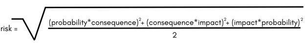
Consistent with CPSE’s Community Risk Assessment: Standards of Cover, the Fire Accreditation Analysis solution uses a modification of Heron’s Formula to evaluate the tetrahedron mass of the three axes, ultimately calculating the fourth point of our tetrahedron: final risk score.
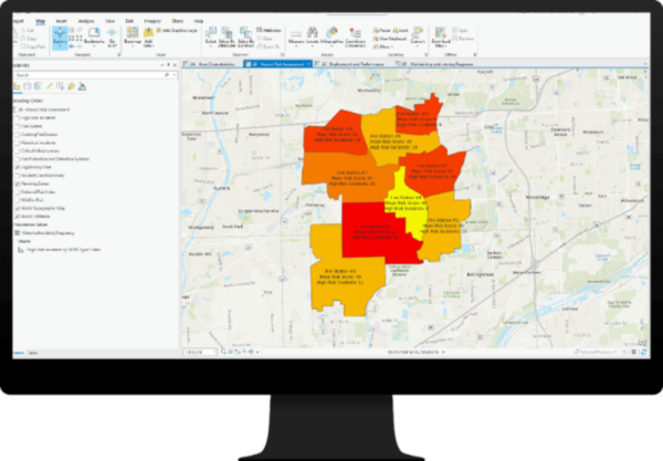
After you have each incident’s total risk score, subsequent tasks walk you through using this data in a high-risk incident layer. This layer is also used to visualize the number of high-risk incidents and the mean risk score for each planning zone. After completing this analysis, you can visualize and export the results as maps and charts.
This powerful update to the Fire Accreditation Analysis solution was built around the structured workflow outlined in CPSE’s documentation and provides a more comprehensive understanding of risk for fire agencies, but even fire agencies not actively pursuing accreditation or reaccreditation can benefit. Any fire agency can use this solution as a standalone tool for identifying, assessing, categorizing, and classifying risks within your jurisdiction.
Resources
We are so happy to share this release with you. For additional information, check out the following resources:
- Learn how to deploy, configure, and use the solution.
- View a demo video.
- Read the Fire Accreditation Analysis Solution Released blog post.
- Learn more about ArcGIS Solutions.
- Chat with us on Esri Community or contact Esri Technical Support.

Article Discussion: