For decades water utilities have relied on GIS as an authoritative repository of information about their distribution systems. As water utilities increase the pace of digital transformation to deal with today’s asset management, funding, resource, and workforce challenges it is critically important to have a modern GIS that keeps asset information up to date and is accessible to all staff and contractors.
To help water distribution utilities map and manage their asset information Esri recently released two new ArcGIS Solutions.
Water Distribution Data Management for ArcGIS Online is designed for utilities that want to use ArcGIS Online for simple asset level mapping and information sharing. It configures ArcGIS Online to be a SaaS water utility GIS.
Water Distribution Data Management for ArcGIS Enterprise is designed for utilities that want to go beyond simple asset level mapping and represent their water distribution system as a utility network. It is the foundational building block for an enterprise water utility GIS implementation.
Both Solutions provide a data model, preconfigured maps, and app configurations for data management. The data models are aligned so water utilities that choose to start with a simple asset representation in a SaaS environment can move to an enterprise deployment and a utility network for more advanced capabilities. Water utilities that want to begin with a more robust implementation can start with Water Distribution Data Management for ArcGIS Enterprise.
The solutions differ in how they are implemented, the ArcGIS software they use, and the app configurations they deploy. The rest of this blog provides an overview of the solutions.
Water Distribution Data Management for ArcGIS Online
Water Distribution Data Management for ArcGIS Online turns ArcGIS Online into a software as a service (SaaS) system for water utilities to inventory their assets, keep information up to date, collaborate, and provide system maps and dashboards to office and field staff.
Deploying this solution takes less than 2 minutes using the ArcGIS Solutions app in ArcGIS Online. To deploy this Solution, first open the ArcGIS Solutions App and then select Water Distribution Data Management for ArcGIS Online. After that click the Get Now Button and you are promoted to specify the spatial reference your data will be stored in. We highly suggest specifying an appropriate spatial reference for your utility. If you do not set a spatial reference than the default spatial reference WGS 1984 Web Mercator Auxiliary Sphere will be used for your data.
In less than 2 minutes the solution is automatically deployed with the necessary feature layers, layer views, maps, groups, and a series of app configuration. The data model includes typical water distribution system assets and the apps are designed to work together as a system. The data model uses only simple features to represent the water system and does not use a network.
Utilities can modify the data model, layers, and maps to reflect their assets and business needs. For example, while this solution deploys configured for imperial units, it can be easily switched to metric units. If unfamiliar with making changes to layers, labels, and maps in ArcGIS online, we suggest engaging Esri Professional Services or an Esri Business Partner to assist you.
These app configurations are deployed:

The solution uses ArcGIS Online groups to simplify permissions and organize maps and apps. After deploying add staff to the appropriate groups. Refer to the Information Products table for ArcGIS Online user types necessary for staff to utilize the apps.
The following groups are deployed:

Utilities with no data can immediately begin mapping their water system in the field using Water Distribution Asset Collector in ArcGIS Field Maps. We highly recommend using a GPS receiver capable of at least sub-meter accuracy for mapping your water distribution assets.

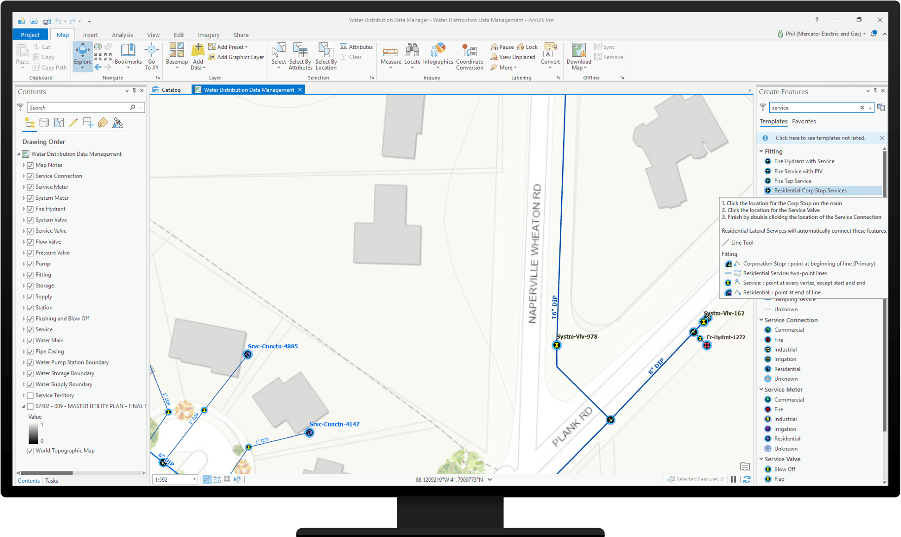
For precision edits, high volumes of edits, importing data from CAD or digitizing assets from as-builts utilities can use the Water Distribution Data Manager project with ArcGIS Pro.
Staff can also map and manage assets in a web browser using the Water Distribution Editor Web App.

Utilities with existing GIS data can load it into Water Distribution Data Management for ArcGIS Online. The Data Loading Tools is one of the ways you can transform and load existing data.
Utility staff can view maps in the the field using the Water Distribution Mobile Viewer with ArcGIS Field Maps.

Office staff can view maps using the Water Distribution Viewer Web App.

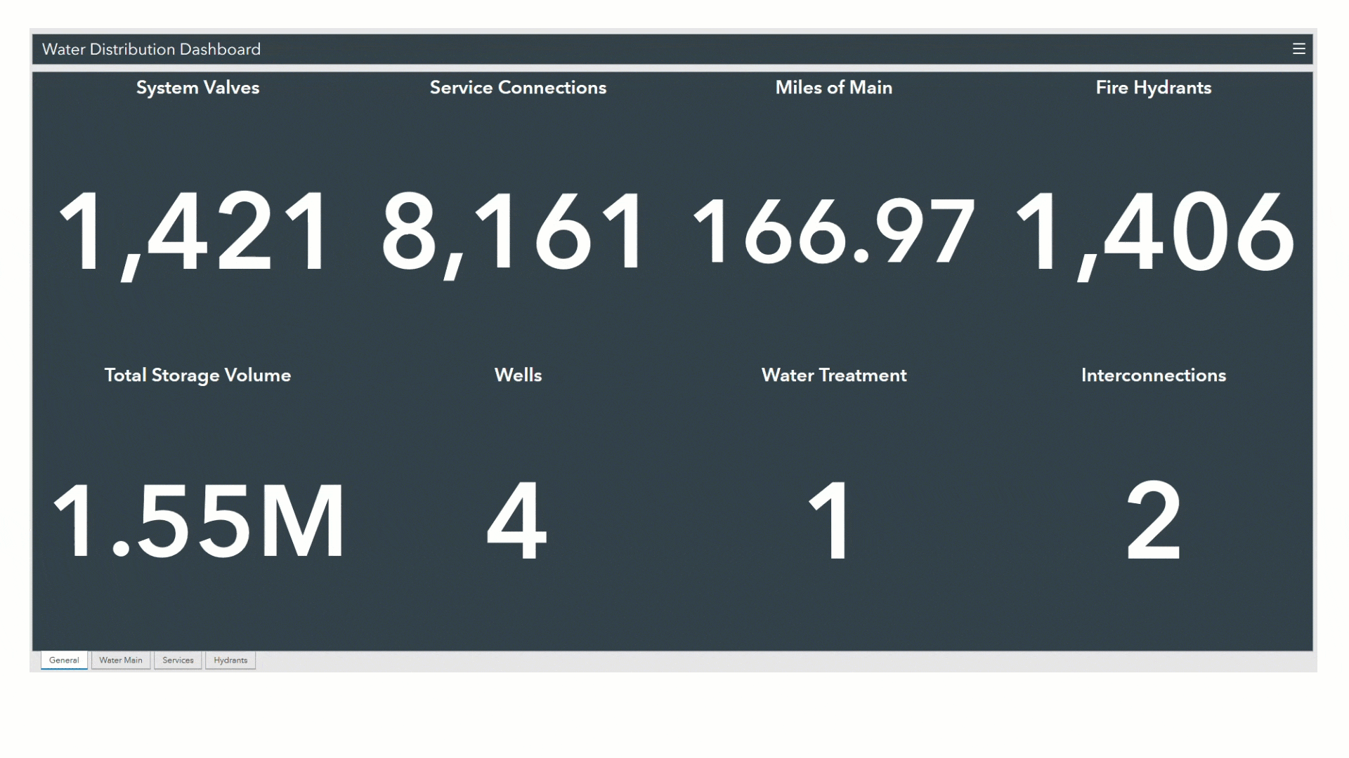
Managers can use the Water Distribution Dashboard to get a high-level view of the assets that comprise the water distribution system.
Water utilities have a long history of using marked up maps to collaborate and share information, especially between the office and the field. This solution includes the ability for staff to create map notes. Map notes can be used to record information like assets that need service, observations, and requests for map changes. The Map Notes Manager Web App can be used to triage map notes requiring action.

Water Distribution Data Management for ArcGIS Enterprise
Water Distribution Data Management for ArcGIS Enterprise is the starting place for utilities that want to manage data about their water distribution system with a utility network in an enterprise environment. This solution is designed to deploy a utility network for water distribution to ArcGIS Enterprise and deliver desktop data management capabilities as the first building block of an enterprise implementation. Utilities should use the services deployed by this solution to build additional desktop, web, and mobile apps.

Representing a water distribution system as a utility network enables utilities to map the individual assets that make up their system and model how those assets operate together in the real world to deliver water. A utility network brings a far richer level of information and analytics then just using simple features.
This solution includes a utility network data model preconfigured with common water system assets and connectivity rules. The data model is extensible so utilities can add additional assets and is localizable. It also includes preconfigured utility network service publishing maps and a data editing configuration for ArcGIS Pro.

The deployment is accomplished through a set of tasks in ArcGIS Pro. The tasks included a curated exploration of the solution with sample data, common workflows, data model configuration, prototyping in a single user environment, and production deployment.

Existing data can be loaded using the Data Loading Tools. After deploying this solution, the published utility network services can be used to create additional desktop, mobile, and web-based data editing apps.
Both Water Distribution Data Management for ArcGIS Online and Water Distribution Data Management for ArcGIS Enterprise are part of Esri’s collection of ArcGIS Solution. ArcGIS Solutions are free and fully supported industry-specific configurations for ArcGIS.
Using either Water Distribution Data Management for ArcGIS Online or Water Distribution Data Management for ArcGIS Enterprise as the foundation of a water utility GIS reduces implementation cost and time.

Great! I start using Water Distribution Data Management for ArcGIS Enterprise and it’s very usefull for me! When to expect Sewer System Data Management for ArcGIS Enterprise? I’ve using the one for ArcGIS Online, but it’s too simple for us.
We plan on releasing Sewer Data Management for ArcGIS Enterprise and Stormwater Data Management for ArcGIS Enterprise in the first quarter of 2021.
Hi! Can you share sample data?