We are excited to announce yet another upcoming in-person Esri User Conference (July 14-18, 2025) in San Diego in just a few weeks! Read on to learn more about activities related to our real-time visualization and analytics products – ArcGIS Velocity and ArcGIS GeoEvent Server.
Schedule a meeting
If you would like to discuss your project requirements and have a 1:1 conversation with the product team, please explore the team’s calendar to schedule a meeting with them during the week of the User Conference.
Join Us at the Showcase
| Day and Date | Time | Location |
| Tuesday, July 15 | 9:00 a.m.–5:00 p.m. | Halls A/B/C/D |
| Wednesday, July 16 | 9:00 a.m.–5:00 p.m. | Halls A/B/C/D |
| Thursday, July 17 | 9:00 a.m.–4:00 p.m. | Halls A/B/C/D |
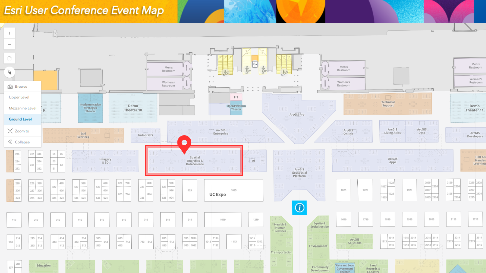
Explore the 2025 Esri UC Events Map via web and mobile (iOS or Android) to locate us in the showcase and navigate to the booth and sessions. You can also consult on-site interactive kiosks in the expo area to get directions at the event venue.
Whether you are interested in seeing the latest updates in ArcGIS Velocity and ArcGIS GeoEvent Server or looking for answers, our experts are available to help! We are located in the Spatial Analytics area within the Esri showcase. Stop by for a chat or to see a product demonstration.
Attend the Sessions
We have curated a list of product-focused sessions to deepen your understanding of real-time GIS.
ArcGIS Velocity: An Overview
Real-time data is crucial to GIS. ArcGIS Velocity is a real-time analysis capability in ArcGIS Online, and it is coming soon to ArcGIS Enterprise. Velocity enables organizations to ingest, visualize, analyze, store, and act on data from Internet of Things (IoT) sensors. Speakers discuss how to connect to virtually any type of streaming data, perform real-time analytics and processing, and automatically disseminate information and alert personnel when specified conditions occur. Learn how to create analytic models to process high-volume historical data to gain insights into patterns, trends, and anomalies in your big data.
Session Type: Technical Session
Tuesday, July 15, 4:00 pm–5:00 pm PT
Room 24 B | SDCC
Thursday, July 17, 2:30 pm–3:30 pm PT
Room 32 B | SDCC
ArcGIS GeoEvent Server: Best Practices for Real-Time Analytics
ArcGIS GeoEvent Server provides real-time visualization and analytics capabilities in ArcGIS Enterprise, enabling organizations to connect with virtually any type of data to derive insights that inform decisions. Join this discussion about best practices for incorporating real-time data feeds with your existing GIS data and IT infrastructure, performing continuous processing and analysis of streaming data with filters and processors, and producing new data streams that work seamlessly across ArcGIS.
Session Type: Technical Session
Wednesday, July 16, 4:00 pm–5:00 pm PT
Room 33 B | SDCC
ArcGIS Velocity: Applying Real-Time and Big Data Analytics
Want to see how ArcGIS Velocity transforms real-time data into actionable insights? In this session, explore how ArcGIS Velocity powers the Street Sweeping Operations Solution by setting up AVL feeds, planning routes, monitoring sweeping activities live, and sharing schedule updates with the public. Speakers also discuss best practices for preparing your data and selecting the right analytic tools within Velocity to maximize operational efficiency and enhance community engagement.
Session Type: Demo Theater Presentation
Thursday, July 17, 11:30 am–12:15 pm PT
Expo Demo Theater 4 | SDCC
Real-Time GIS: The Road Ahead
Join us to explore the future of real-time GIS at Esri. ArcGIS Velocity is expanding to ArcGIS Enterprise for Windows and Linux next year. Also, learn about upcoming capabilities, deployment options, and what’s next for real-time GIS.
Session Type: Technical Session
Thursday, July 17, 4:00 pm–5:00 pm PT
Room 15 B | SDCC
Additional Sessions Where You Will Find Real-Time Content
In addition to product-focused sessions, real-time GIS will be featured across many sessions at UC. We have curated a list of sessions where real-time GIS plays a critical role in the workflow.
ArcGIS: Hazard Impact Analysis
Join us to find out how ArcGIS technology serves as an analytic tool to measure and visualize impacts caused by natural and human-made hazards that impact populations, critical infrastructure, and organizational assets.
Session Type: Demo Theater Presentation
Tuesday, July 15, 11:30 am–12:15 pm PT
Expo Demo Theater 12 | SDCC
Smart Streets and Savvy Fleets
Discover how GIS technology is transforming fleet management and service request systems in Carlsbad and Los Angeles. Carlsbad’s fleet manager selected GIS to streamline risk mitigation, document accidents, and develop prevention plans, which led to cost reductions.
Session Type: User Presentations
Wednesday, July 16, 8:30 am–9:30 am PT
Pacific Ballroom Salon 18 | Marriott
Use of GIS in Supporting Renewable Operations
This session will explore the pivotal role of GIS technology in enhancing the efficiency and effectiveness of renewable energy operations. Ørsted will share how they leverage Esri’s tools to optimize the performance of their offshore wind farms, ensuring they contribute to a sustainable energy future.
Session Type: User Presentations
Wednesday, July 16, 10:00 am–11:00 am PT
Pacific Ballroom Salon 18 | Marriott
ArcGIS Field Maps: Tracking First Responder Locations
Learn how to implement real-time location sharing through ArcGIS Field Maps. Speakers guide you through the essentials of configuring and enabling location sharing within your own organization, enhancing situational awareness and safety across teams.
Session Type: Demo Theater Presentation
Wednesday, July 16, 1:00 pm–1:45 pm PT
Expo OPS Center Demo Theater | SDCC
The Era of Digital Twins Has Landed
Major airports like Dallas Fort Worth International Airport (DFW) and San Francisco International Airport (SFO) leverage cutting-edge technologies to enhance operational efficiency and decision-making.
Session Type: User Presentation
Wednesday, July 16, 2:30 pm–3:30 pm PT
Room 28 E | SDCC
Resources
Here are a few additional resources:
- ArcGIS Velocity product information, resources, and user community
- ArcGIS GeoEvent Server product information and user community
- Read about our real-time data providers and sources
- Explore, save, and share a custom real-time session agenda
Haven’t registered for the user conference? It’s not too late. Join the in-person event, register for digital access, or watch the Plenary Session only.
Register Here
See you in San Diego!

Article Discussion: