ArcGIS Velocity is the real-time extension for ArcGIS Online, enabling organizations to ingest, visualize, analyze, and act on data from sensors and asset tracks. It also enables processing of high-volume historical data to gain insights into patterns, trends, and anomalies. Tracking assets such as vehicles and fleets for a current view on operations, analyzing personnel movement to ensure safety, and monitoring changing conditions for more informed decisions are just a few of the benefits you can gain from your sensor and Internet of Things (IoT) data using Velocity.
ArcGIS Velocity is updated regularly, below are several highlights of the June 2025 release:
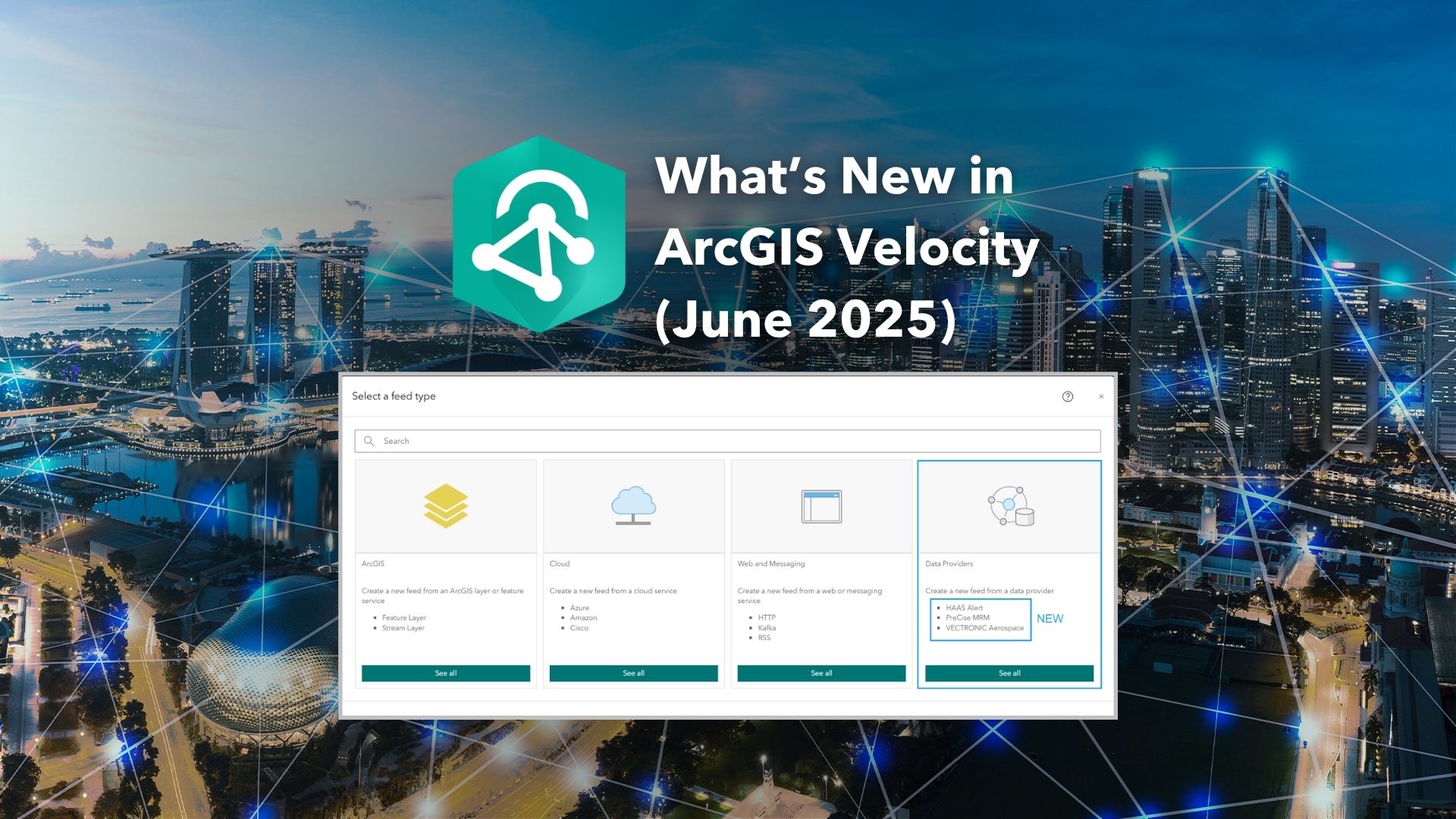
Feeds
- Monitor wildlife locations and perform real-time movement analysis by accessing global positioning system (GPS) data from wildlife tracking collars from VECTRONIC Aerospace Inc with the VECTRONIC Aerospace feed type.
- Quickly ingest fleet and Automatic Vehicle Locations (AVL) data from PreCise MRM to support fleet management with the PreCise MRM feed type.
- The HAAS Alert feed type offers data on emergency vehicle locations, work zones, and other road hazards.
Integrations
- Integrating Trimble Unity Maintain with Velocity allows real-time work order automation from events and triggers in the field.
Analytics
- Dynamically generate points from multipoint, polyline, polygon, or envelope geometries to reduce unnecessary geometric data with the Feature to Point tool.
- Correct out-of-sequence data on the fly with the Delay and Reorder Tracks analytic tool.
General
- Explore the other enhancements and bug fixes in this release with a complete list of what’s new.
Now, let us take a deeper dive into each of these and other new capabilities and enhancements in this release!
Feeds

With the VECTRONIC Aerospace feed, you can now ingest global positioning system (GPS) data from wildlife tracking collars in Velocity, provided by VECTRONIC Aerospace. The data from the feed can be used to update the Dynamic Message Sign (DMS) alerting motorists to stay vigilant and slow down when animals are in the area. Planners and stakeholders can also leverage movement data to design secure and sustainable wildlife corridors. One notable project involves the Nebraska Department of Transportation (NDOT), who used location data from VECTRONIC collars on bighorn sheep to guide construction of new wildlife-crossing areas. This initiative helped reduce wildlife-vehicle collisions by tracking the sheep’s movements.
If you are interested in learning more, explore our blog.
To learn about configuring the new feed type and the six supported event data types, check out VECTRONIC Aerospace documentation.

The PreCise MRM feed type in ArcGIS Velocity is a new integration that connects Automatic Vehicle location (AVL) and telematics data provided by PreCise MRM. It delivers real-time data from onboard devices including vehicle location, speed, activity, and equipment status. This integration is useful for public works, construction, and utilities with use cases such as fleet tracking, asset management, driver compliance, and material usage reporting. For example, a city’s public works department can use it to monitor snowplow activity, a utility company can track repair crews, and a construction firm can supervise equipment usage.

The HAAS Alert feed type uses HAAS Alert’s Safety Cloud for digital alerting to enhance roadway safety and situational awareness. Anyone who works across transportation-related sectors, such as automotive, government, law enforcement, fire or EMS, utilities, DOTs and other commercial organizations can benefit from using the HAAS Alert feed by informing the nearby drivers about hazards like emergency vehicles or work zone. To learn more about configuring this new feed type and the hazard types, check out the HAAS Alert documentation.
When an emergency vehicle, such as a police patrol car, fire truck, or ambulance activates its lights, it is signaling to the public that they need to be noticed. This notification ensures the safety of first responders and the public. HAAS Alert has collaborated with agencies to assist in broadcasting when these emergency lights are activated. This data can be advantageous for various organizations, including departments of transportation, which may utilize maps and alerts to monitor where emergency vehicles are currently active. This information not only enhances situational awareness but can also be employed to inform personnel, contributing to the safety of both first responders and the general public.

Integrations
The Trimble Unity Maintain integration in Velocity enables real-time and big data analytics to automatically generate work orders based on incoming events. Users can assign work orders or tasks manually or dynamically, map the incoming data to Trimble’s schema, and track maintenance activities with full visibility, making it ideal for infrastructure monitoring, emergency response, and asset management. For instance, a utility company can use it to monitor sensors and automatically trigger maintenance work orders when high temperatures are detected. After a storm, it can analyze the flood data and then dispatch response teams if predefined thresholds are exceeded. To start using these capabilities, reach out to Trimble to get your user access credentials.

Analytics
The Feature to Point tool calculates the centroid of a polygon feature to show the center of mass in real time. For example, a polygon feature representing a live hurricane can be reduced to a point centroid to show the generalized eye of the storm. Reduce multipoint, polyline, polygon, or envelope features to a point to improve event record throughput and storage performance. Polygon or polyline features with thousands of vertices can impact the performance of real-time analytics in ArcGIS Velocity.

The Delay and Reorder Tracks tool addresses the challenges of real-time location privacy and out of sequence track-based data. By delaying the display of real-time locations, it ensures that sensitive information remains secure. Sometimes track-based data provided by vendors and sensor APIs is out-of-sequence causing issues with your real-time analytics. The Delay and Reorder Tracks tool will enable you to reorder the data, so it is accurately organized by timestamp within a specified time window. It processes feature data received in batches by delaying processing until a complete batch is obtained, then reordering the events by timestamp. This capability significantly enhances the efficiency and accuracy of real-time analytics, providing structured and timely data for improved decision-making and performance in ArcGIS Velocity.

For more details on the latest release of ArcGIS Velocity, please visit the what’s new documentation.
Headed to the Esri User Conference in July?
Explore the agenda for Real-Time GIS at the 2025 Esri User Conference, browse through our session catalogue, schedule a 1:1 meeting with the product team on-site, and find out where to locate us in the showcase!


Article Discussion: