3D in ArcGIS helps you create a more intelligent world by turning spatial data into realistic, interactive environments for understanding complexity, evaluating impact, and coordinating action.
Explore 3D GIS at UC 2026
If you are attending UC 2026, 3D GIS offers a powerful way to see this year’s theme, GIS: Creating a more intelligent world, in action. With 3D in ArcGIS, you can explore places, projects, and systems in realistic, interactive environments that make it easier to understand complexity, evaluate impact, and coordinate action.
Throughout the week, you can connect with Esri experts, see 3D capabilities in action, and learn how 3D supports workflows across planning, infrastructure, AEC, operations, natural resources, and digital twins.
A quick look at 3D GIS
3D is an essential part of ArcGIS, helping users better understand the physical world through realistic, interactive views of their data. By bringing layers of information into a 3D environment, users can more easily see spatial relationships, explore context, and communicate complex ideas in a way others can quickly understand.
Across ArcGIS, 3D supports a wide range of workflows, from managing 3D content and visualizing complex environments to analyzing impact and creating immersive experiences. Users can work with data such as BIM, lidar, point clouds, meshes, and 3D objects, then share that content across web, mobile, desktop, and XR experiences.
A useful way to understand 3D GIS is through three patterns: publish, decide, and operate. Users publish trusted 3D content as a shared baseline, decide with 3D by evaluating options and understanding potential impacts, and operate in 3D by coordinating work in connected environments as conditions change. Together, these patterns help support digital twin workflows by connecting data, systems, and people through a shared 3D view of reality.
Explore 3D sessions
Want to keep learning throughout the week? Explore the 3D custom agenda to find technical sessions, demos, and presentations focused on 3D GIS, digital twins, immersive experiences, analysis, and connected 3D workflows.
Use the agenda to add sessions to your schedule or mark the ones you are interested in as favorites before UC begins.
Featured Sessions:
| Session | Date/Time | Location |
| Immersive Mapping: The Power of 3D in ArcGIS – Learn how 3D in ArcGIS helps users publish trusted 3D content, decide with 3Dcontext, and operate in connected 3D environments. | Tue, Jul 14, 10 AM to 11 AM PDT
Wed, Jul 15, 4 PM to 5 PM PDT |
Ballroom 20 D
Ballroom 6 A |
| Scene Viewer in Action: Creating Dynamic 3D Web Experiences – See how Scene Viewer helps you create, explore, analyze, and share dynamic 3Dweb scenes in ArcGIS. | Tue, Jul 14, 11:30 AM to 12:15 PM PDT | Demo Expo Theater 5 |
| ArcGIS: Explore Data Interactively with Extended Reality – Explore how extended reality brings GIS data into immersive experiences for visualization, review, and decision making. | Tue, Jul 14, 1 PM to 2 PM PDT | Room 7 B |
| Digital Twin for Event Planning and Emergency Management – Learn how digital twin workflows can support event planning, emergency management, coordination, and response. | Wed, Jul 15, 4 PM to 5 PM PDT | Room 17 A |
Check out the 3D custom agenda to find more 3D sessions, demos, and activities throughout the week.
Find us on the Expo floor
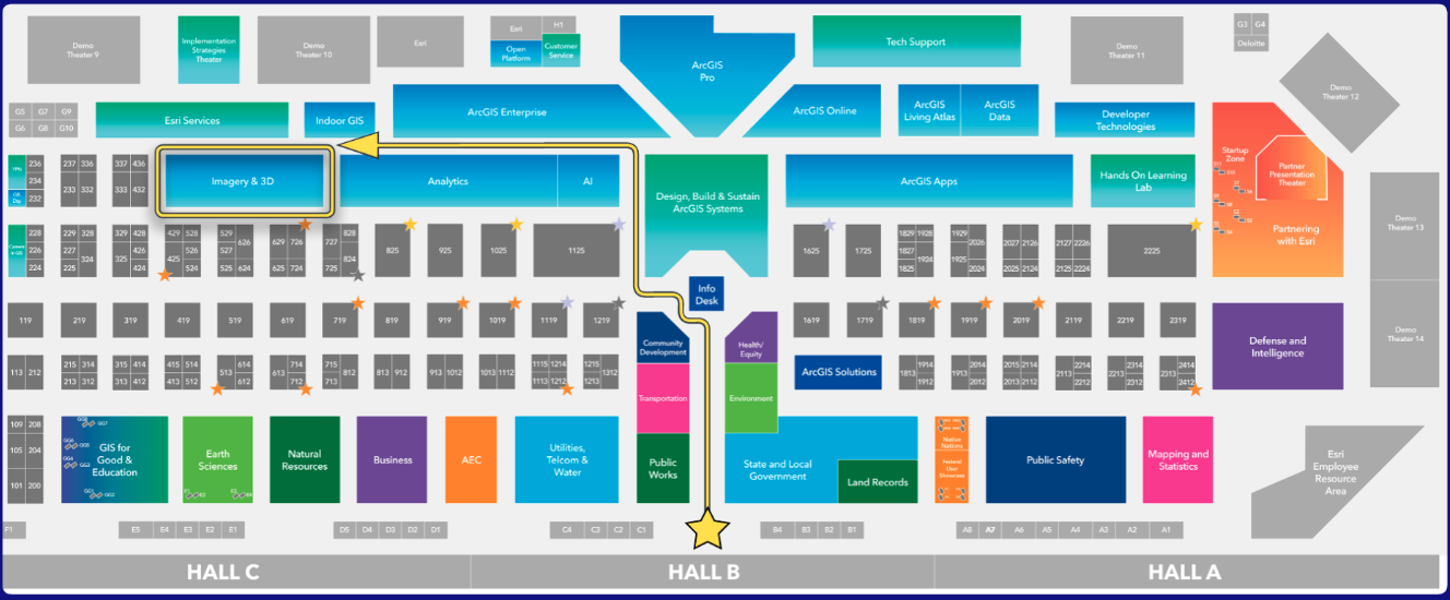
Use the Event Map or the floor plan below to find where 3D GIS will be located at UC 2026.
Expo hours
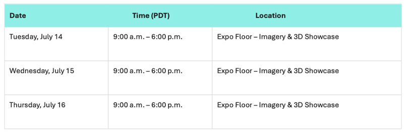
Planning your visit? Use the Expo hours below to find a time to stop by the Imagery & 3D showcase, explore demos, and connect with the teams supporting 3D across ArcGIS.
See you in San Diego
We look forward to seeing you at UC 2026. Whether you are just getting started with 3D or looking to expand your existing workflows, this is a great opportunity to explore how 3D in ArcGIS can help you understand complexity, evaluate impact, and coordinate action.


Article Discussion: