The wait is finally over! Oriented imagery 2.6 is here with some exciting new features, including a new superimpose view on the web, the ability to access local image files in the ArcGIS Pro add-in, new Time Selector and Image Attributes tools, enhanced video support, enhancements to the Navigation tool, and much more. We’ll also be releasing an Oriented Imagery widget for Experience Builder in a couple weeks, so you’ll be able to build your own custom app.
Oriented Imagery is a capability within ArcGIS that provides users the ability to manage, visualize, exploit, and analyze many types of imagery, including street-side, 360, drone, aerial, video, and terrestrial images captured by many different cameras. Visit the Managing and Visualizing Oriented Imagery workflow page to learn more about oriented imagery and how it can be incorporated into your GIS.

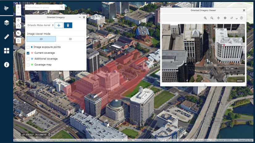
Use superimpose view to visualize imagery in 3D web scenes
With the new 3D viewing experience on the web, you can superimpose imagery into web scenes on top of both vector layers and 3D data layers (including point cloud, mesh, and building layers). You can adjust the position of the image superimposed in the scene using the image depth slider in the viewer (see it in action below). You can also measure and digitize in web scenes using imagery as the reference. Just FYI, superimpose view is available only on the web platform, and videos are currently not supported.

Directly access images on local disk in the ArcGIS Pro add-in
Prior to the 2.6 release, you had to upload the images to cloud storage before you could visualize images in the Oriented Imagery viewer. In the Oriented Imagery Pro Add-In 2.6, you can now view the images on your local disk in the viewer without uploading them to cloud. (To visualize and exploit imagery on the web, you’ll still need to upload the images to cloud).
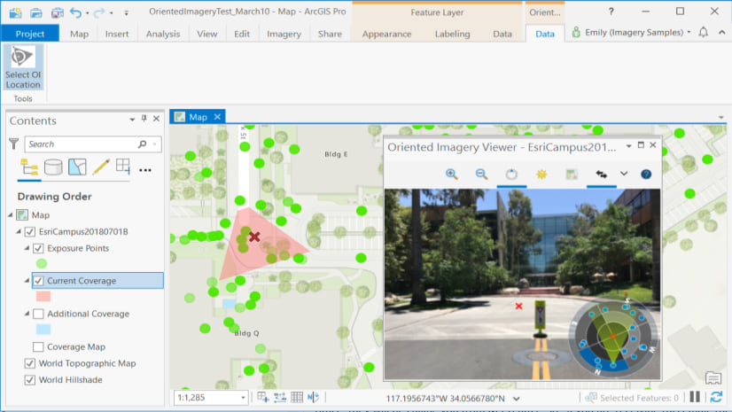
Preview an oriented imagery catalog in the ArcGIS Pro add-in
You can now preview an OIC in the ArcGIS Pro add-in before publishing it to ArcGIS Online or your ArcGIS Enterprise portal. You can also test and update OIC parameters in the authoring mode using the OIC Properties GP tool or in the attribute table. (To visualize and exploit imagery on the web, you’ll still need to publish an OIC to ArcGIS Online or your ArcGIS Enterprise portal.)
Easily create OICs with video (plus support for 360 videos)
With the new Geospatial Video image type, you can now easily create oriented imagery catalogs (OIC) from video files that are accompanied by geospatial log files. Once the catalog has been created, you can visualize the video in the Oriented Imagery viewer on the web. (Video is currently not supported in ArcGIS Pro add-in.)

In the 2.6 release, we also added support for 360 videos. See the coverage area graphic update dynamically on the map as you pan and zoom in a 360 video.
Time Selector tool
Use the Time Selector tool to compare images containing the selected point of interest taken at different times. You can switch between images taken days, weeks, months, or years apart from each other. This tool comes in handy when you want to compare before and after images for a property damaged after a natural disaster, like a fire or hurricane, or you want to monitor the progress being made at a construction site.

Image Attributes tool
You can view the attributes for the current image using image attributes tool in the Oriented Imagery viewer . Note – Default oriented imagery attributes are not shown.

Adjust the size of the Navigation tool
You can now increase the size of navigation tool in the Oriented Imagery viewer by clicking on the outermost ring segment.

Oriented Imagery widget for Experience Builder
Want to add the oriented imagery capability in your custom web apps? Using Oriented Imagery widget for Experience Builder Developer Edition, you can now empower your web apps to visualize and exploit oriented imagery without writing a single line of code. Download the latest widget from GitHub once it has been released.
Ready to give these new enhancements a try? Check out these resources to get you started:
- Find oriented imagery resources on the Imagery Workflows page
- Learn more about oriented imagery through our earlier blog
- Learn how to digitize features in Oriented Imagery
- Get access to developer resources for Oriented imagery
- Learn how to create custom apps using Experience Builder Developer Edition
Have questions or need help with Oriented Imagery? Let us know on Esri Community page.


Oriented imagery widget for Experience Builder Developer Edition has been released on GitHub.