By now you’ve probably heard about the Aurora Project, the codename for the next generation Collector app, but you might not know how awesome the maps are going to be. I’ve blogged about the UX improvements and finding your assets with a point-to-point navigation. But do you know about the updates coming to the maps? Labels, vector tiles, and advanced symbology will all be supported.
Labels
If you use Collector, you are probably one of the many who want labels in your maps (the labels in Collector suggestion on the ArcGIS Ideas site has been voted up over 350 times, and has over 9000 views). Yes, they are coming with Aurora.
In addition to basic labels, Collector will support labels created with Arcade expressions. If you have an asset you want to label based on a key piece of information, that key info might change as you are editing your data in the field. And with Aurora, a label containing the same key info will update when the data does.
Here, a pipe had the wrong material specified. When it is corrected, the label also updates.
Vector tiles
Vector tile basemaps bring crisp, responsive maps and now you can take advantage of them in Collector. If you include labels in your basemap, they’ll rotate with your map. If you are working offline, you no longer choose the levels of detail you care about—you can zoom in as far as you need. With a combination of tile access performance and vector drawing, vector tiles adapt to any resolution display for great looking maps across all mobile devices.
Advanced symbology
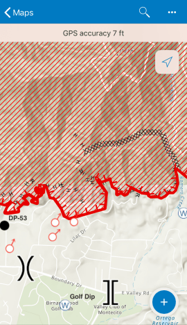
A fire incident map uses specialized symbology: all the team members on the ground know the symbols. Reading the uncontrolled fire edge, temporary flight restrictions, and dozer lines is second nature. Complex symbols, including these and those supporting other workflows, are supported with the Aurora Project.

Your maps
Now that you know what is coming, think about the maps you are using for data collection. Are there things here that excited you and that you’ve been waiting for? Or perhaps there was something you haven’t thought about incorporating. Create some maps that are ready for the Aurora Project release of Collector so that you can hit the ground running with stellar maps.


Commenting is not enabled for this article.