Note: this article was updated in May 2022 to clarify what imagery is available today and reference new options for using the imagery in other custom applications.
OpenStreetMap is a free, editable map built by volunteers largely from scratch and released with an open-content license. Since its inception, this global community has grown to over four million registered OSM users. The HOT (Humanitarian OpenStreetMap Team) in particular focuses on crisis mapping around the globe, introducing a diverse user community to the power of spatial data, making extensive use of satellite imagery donated by a variety of organizations for projects often taken up in the wake of natural disaster.
Esri is proud to announce that we are making our own global collection of satellite imagery available to the OSM community for mapping through our ArcGIS Online World Imagery service. This regularly updated resource provides one meter or better satellite and aerial imagery around the world so we know it will make a welcome addition to OSM’s growing catalog of reference layers to be used for editing.
The imagery can be used in all OSM’s great editors (JOSM, Potlatch 2, Vespucci etc.) but the easiest way to check it out is the simple and friendly web editor iD v2.4.0+.
1. open iD (an OSM account is required)
2. Type B or click Background Settings
3. Choose Esri World Imagery from the gallery.
4. Start contributing!
We couldn’t be happier to serve up the tiles, but this partnership is only possible due to the support of both our commercial imagery providers and fantastic contributions to our Community Maps program. Our sincere gratitude to Maxar, Earthstar Geographics, and the entire GIS User Community that have contributed imagery.
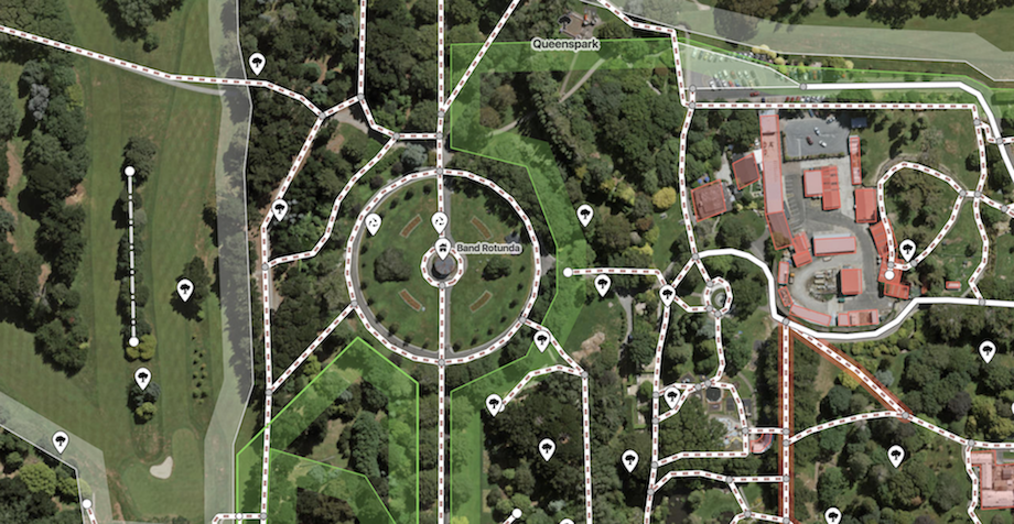
For example, below you can see 5cm resolution (20cm accuracy) imagery of the City of Invercargill, New Zealand, captured in January 2016!
We’ll also be at SOTMUS (State of the Map US) in October discussing tools we are creating to make it easier for our customers to share accurate, properly licensed spatial data with the OSM community in the tremendously popular web editor iD, so please come find us and say hello!
If you can’t make it to Denver, you can also find us on the interwebs:
- osm@esri.com
- http://thespatialcommunity.org (#openstreetmap)
- https://help.openstreetmap.org/users/14112/john-gravois
- https://twitter.com/geogangster
To provide clarity on the allowed use for this ArcGIS Online imagery, we have created a short, readable Permitted Uses document that specifically discusses data collection and editing. If you’d like to use Esri imagery in applications outside of ArcGIS Online and OSM editors leveraging this imagery contribution, please check out Esri’s ArcGIS Platform capabilities and services.

Article Discussion: