![]() During the evening of Monday, March 2, 2015, ArcGIS Online updated. That’s the beauty of the Cloud – it just updates for you. A lot of great new features came into the platform and you can find out everything that is new in this blog article. Guess what – the Browser app updated as well. Read the What’s New to see our changes for the Operations Dashboard.
During the evening of Monday, March 2, 2015, ArcGIS Online updated. That’s the beauty of the Cloud – it just updates for you. A lot of great new features came into the platform and you can find out everything that is new in this blog article. Guess what – the Browser app updated as well. Read the What’s New to see our changes for the Operations Dashboard.
In this previous blog article about the Operations Dashboard 10.3 release, you learned how to become a GIS hero by showing how quickly you can assemble a killer operation view in just 15 minutes without writing any code. But then what? You shared it to people that have a login to your organization and you are the coolest. Then your boss says, “the contractor needs to see it on their laptop right now”, or even better, the boss says their boss heard about it and wants it on their iPad! But neither of them have logins to the org. The big boss uses public web apps and we just don’t give logins to the contractors. So now what??
Well, if this were last week, your famed prowess with maps and apps would quickly turn lame because the people that need it couldn’t open it. But not today! You are back on top! Now you can share your work with Everyone!
Here is our public view, now learn how to do it yourself!
Creating Public Content
To do this properly, let’s go back to that previous blog article where you received your hero badge and step through this once again before your hero badge gets ripped off your sleeve.
If you remember, the first step was to create your map. That included publishing the traffic cams layer and then adding the World Traffic Service to your map as well. If you showed off your work then you probably shared everything in a group. If you now want that map to be publicly accessible, you need to make sure that all the web layers, services, the map and the operation view are shared with “Everyone”.
In the hero blog we created a Toronto Traffic Cameras operation view that included a Toronto Traffic web map and a traffic_cameras feature layer. Inside of the web map we added a layer called World Traffic Service. Well that is a premium map service and it requires an ArcGIS Online login to use it! Hmmm. That was fine when we were sharing the operation view to others that have their own account but what about publicly? Now what do you do?
Making a Premium Layer available for Public Access
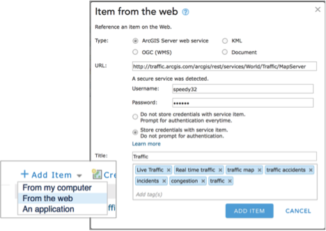
Well you need to embed a login with the layer itself and share it. To do that you need to create a map image layer inside of your content that includes the username and password. Tap “Add Item”, choose “From the web”, ensure the type is ArcGIS Server web service, paste the URL for the World Traffic Service layer (“http://traffic.arcgis.com/arcgis/rest/services/World/Traffic/MapServer”) itself into the URL, add your username and password, make sure to choose the option to “Store credentials with service item” and then just give it a meaningful name.
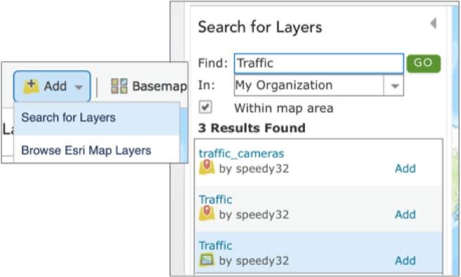
Now that you have an item for the World Traffic Layer in your content, you can add that new Traffic item to your web map and the credentials will be stored within the layer itself. Within the map, click “Add” and select “Search for Layers”. Then type Traffic in the Find dialog. This will search your organization and locate your new layer. Add it to the map and save it!
Ok so now you have your map, go on with the hero blog and create that stellar operation view now that you have the Traffic layer with it’s embedded credentials.
Sharing all items with Everyone
Now that you have your amazing operation view again, you need to share it so you can badge up! First all those items need to be shared with Everyone! Within your My Content view, select all of your items and then click Share. Make sure that you check Everyone so that you ensure public access! You might want to take a look at the editing properties of any feature layers (like the traffic_cameras layer) and disable editing!
Hero Tip: Once you share your items, sign out of your organization, search for the web map and try to open it. If it fails to open or complains about a layer, you missed something!
Your Organization and Public Access
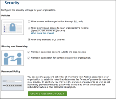
There are a couple of other things you need to consider when sharing stuff publically if you haven’t before. The Administrator of your ArcGIS Online subscription needs to support your endeavors to share content publically. Within the Security settings of your organization, make sure that you Allow anonymous access to your organization. Also make sure that members can share content outside of the organization. Finally, if you have modified the Password Policy so that a user’s password will expire then make sure you remember to update any items that embed credentials!
You should be done! Now call a friend, send them the URL for your amazing new operation view and check and see if they can open it! Here is that public view that we created for this blog article one more time. Make it happen in your organization today and then tell us about it by emailing Dashboard4ArcGIS@esri.com!


Article Discussion: