Knowing where underground infrastructure is located is critical to keeping people safe, preventing costly utility strikes, and maintaining reliable networks.
Yet locating and mapping are often separate activities. Crews locate and mark underground assets, while updating the GIS can require a separate survey or additional processing.
With the November 2026 release, ArcGIS Field Maps brings these workflows together with support for RTK-enabled utility line locators. These devices combine utility locating with high-accuracy GNSS positioning, allowing crews to locate buried pipes and cables while capturing their position, depth, and other locate information directly in Field Maps.
Capture underground utilities as you locate them
In the field, Field Maps introduces a new capture experience designed specifically for utility locating. The mobile worker starts capture in Field Maps and selects the utility type if there is more than one, such as electric, gas, water, or communications.
From there, capture moves to the locator. The worker can put the phone or tablet away and focus on locating the underground utility. As they move along the utility, positions captured from the locator add vertices to the line being mapped in Field Maps.
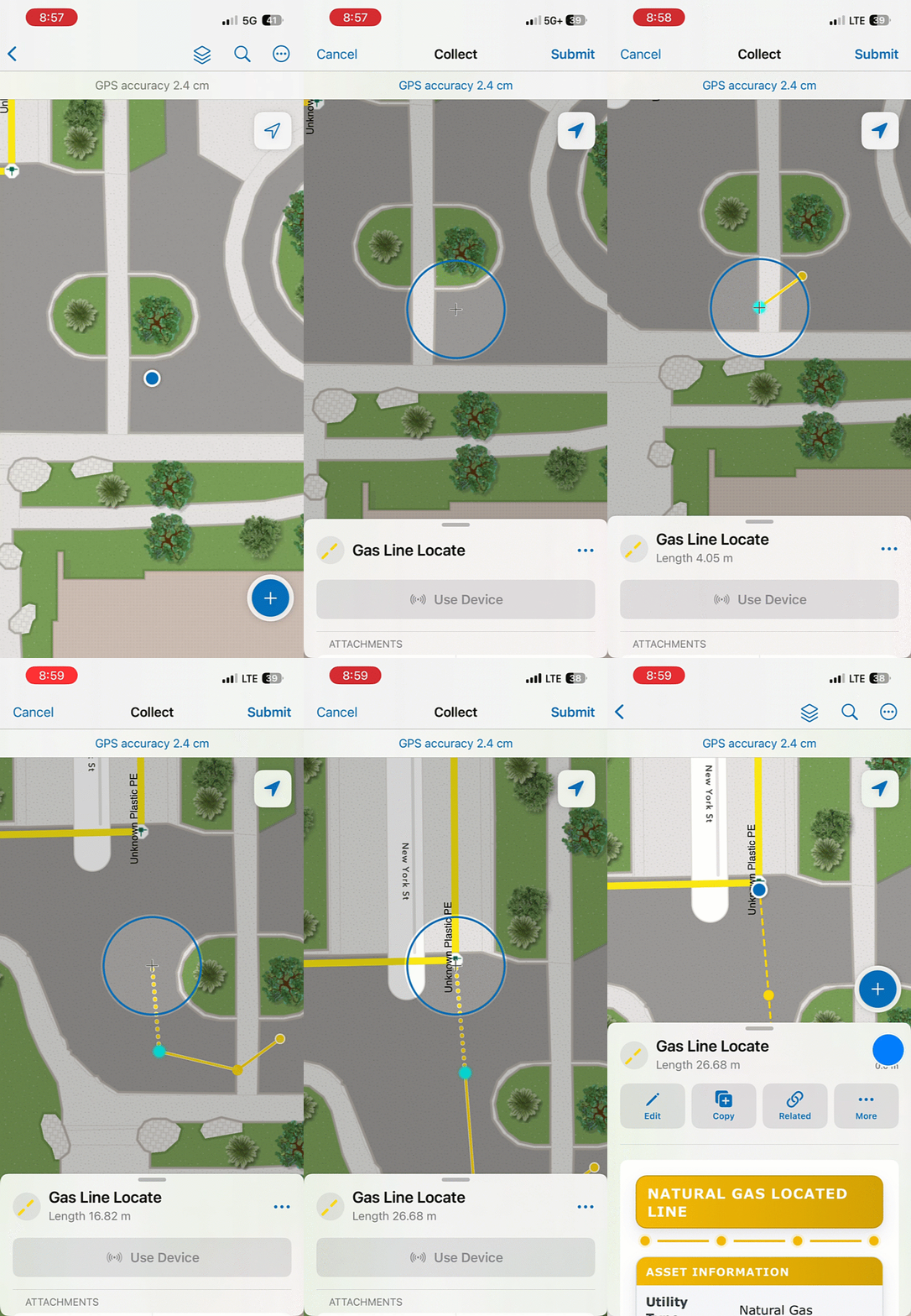
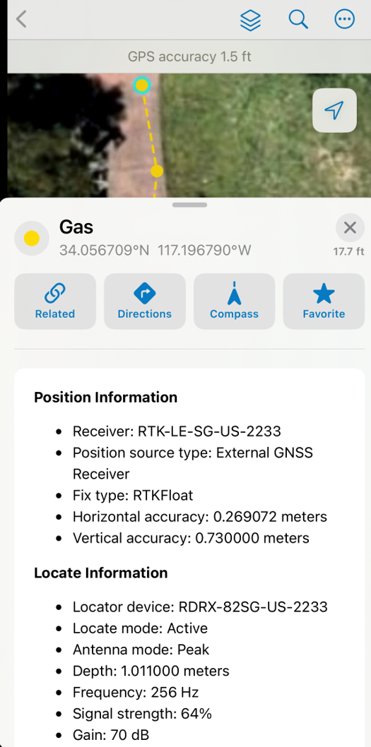
Each position also creates a related locate point, automatically recording the GNSS and locator information associated with that measurement. This can include position accuracy, depth, frequency, signal strength, locate mode, current, utility direction, and the locator used.
Getting Started
Before you start collecting underground utilities in Field Maps, you’ll need:
- A supported RTK-capable utility line locator – these include Radiodetection and Subsite locators, with Vivax-Metrotech locators available in beta
- A Line Locate map created and configured from the provided template in Field Maps Designer
- ArcGIS Field Maps and the locator manufacturer’s companion app installed and configured
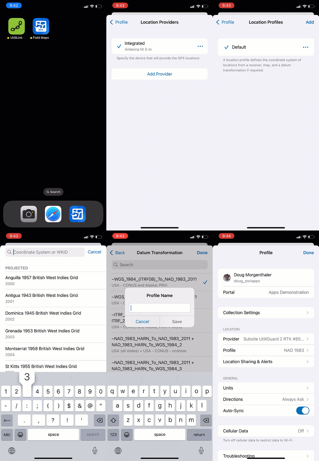
Similar to GNSS receivers, the utility line locator is configured as a location provider in Field Maps. The manufacturer’s companion app maintains the connection to the locator and the correction source used to provide centimeter-level positioning.
Line Locate Template
To simplify the mapping setup, Field Maps Designer includes a new Line Locate map template.
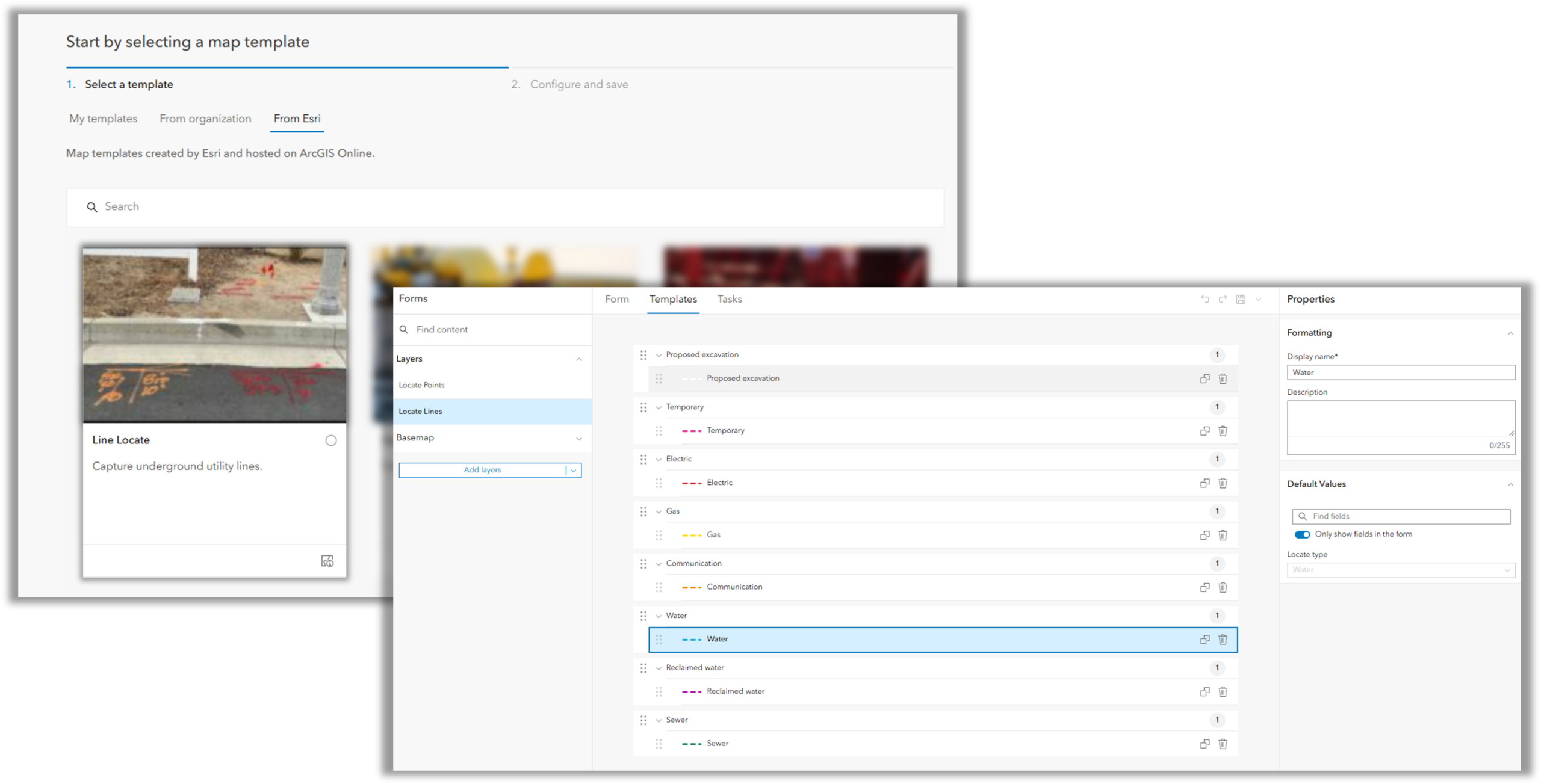
The template creates two related layers:
- Locate Lines is the primary layer used to map the underground utility and capture information such as utility type, ticket number, and photos.
- Locate Points are created automatically for each position captured from the locator and store the GNSS and locator metadata associated with that measurement.
There is also an ArcGIS Pro project available here which can be used to publish the Line Locate map to ArcGIS Enterprise and ArcGIS Online.
Locate Lines Layer
The Locate Lines layer represents the underground utility being mapped and is the primary layer the mobile worker interacts with during capture.
It includes the following attributes:
| Field | Name and Type | Values | |
| Label | Code | ||
| Locate type | esrilocate_line_type – string field, 20 character length | Communication | communication |
| Electric | electric | ||
| Gas | gas | ||
| Proposed excavation | proposed | ||
| Reclaimed water | reclaimed_water | ||
| Sewer | sewer | ||
| Temporary | temporary | ||
| Water | Water | ||
| Ticket number | ticket_number – string field, 50 character length | ||
Locate Points layer
As positions are captured from the locator, Field Maps automatically creates related Locate Points along the line. Each point preserves the GNSS information and locator measurements associated with that individual capture.
It includes the following attributes:
- All of the GNSS attributes documented in the Prepare your data documentation topic applied to point features.
- The following line locate metadata:
| Field | Name and Type | Values | |
| Name | Code | ||
| Locate type | esrilocate_point_type – string field, 20 character length | Communication | communication |
| Electric | electric | ||
| Gas | gas | ||
| Proposed excavation | proposed | ||
| Reclaimed water | reclaimed_water | ||
| Sewer | sewer | ||
| Temporary | temporary | ||
| Water | Water | ||
| Antenna mode | esrilocate_antenna_mode, string field, 20 characters | Potential values include:
Broad Broad + arrows Guidance Left Right auto Left Right manual Null Omni peak Omni broad Peak Peak + arrows Peak + null |
|
| Left/Right/Null arrows | esrilocate_arrows, small integer field | Range domain (-100 to 100)
|
|
| Direction of utility (°)
Units are Degrees Alignment angle of a locator to the target line in degrees
|
esrilocate_utility_compass, small integer field | 0-360
|
|
| Current mA
Units are milliamps |
esrilocate_current, double field | ||
| Direction of current | esrilocate_direction_of_current, small integer field | None | 0 |
| Forward | 1 | ||
| Reverse | 2 | ||
| Unknown | 3 | ||
| Custom attributes | esrilocate_custom_attributes, string field, 2000 characters | ||
| Depth (m)
Units are meters |
esrilocate_depth, double field | ||
| Frequency (Hz) | esrilocate_frequency, integer field | ||
| Gain (dB) | esrilocate_gain, small integer field | ||
| Locate mode | esrilocate_locate_mode, string field, 20 characters | Potential values include:
Active, Power, Radio, Cathodic, CATV, RFMarker, Sonde |
|
| Locator device | esrilocate_locator, string field, 50 characters | ||
| Locate line GUID | locate_line_guid, GUID | ||
| Log date
Unit are ms since Unix epoch |
esrilocate_log_datetime, date field | ||
| Signal strength (%) | esrilocate_signal_strength_per, small integer field | Range domain (0-100)
|
|
| Marker type
Populated when using a locator that supports capture of a marker and a marker is found. |
esrilocate_marker_type, small integer field | Power (Red) | 169.8kHz | 0 |
| Water (Blue) | 145.7kHz | 1 | ||
| Euro power (Blue/Red) | 134.0kHz | 2 | ||
| Wastewater (Green) | 121.6kHz | 3 | ||
| Telecom (Orange) | 101.4kHz | 4 | ||
| Gas (Yellow) | 83.0kHz | 5 | ||
| CATV and communications (Black/Orange) | 77.0kHz | 6 | ||
| General and Reclaimed water (Purple) | 66.35kHz | 7 | ||
| French power (Natural) | 40.0kHz | 8 | ||
| Ticket number | ticket_number – string field, 50 character length | ||
Configure for Workflow
The Line Locate map provides a starting point that can be adapted to your organization’s locate workflow. Using Field Maps Designer, map authors can:
- Add additional fields needed for capture, using the Locate line layer for user-entered values, default values, and form calculations. Locate point layer fields can use default values and form calculations, but cannot accept user-entered values during collection.
- Customize utility types and feature templates, removing those that aren’t relevant or setting default values to simplify capture.
- Add existing utility and asset layers to give crews context while they work or capture additional above ground assets.
- Use calculations to derive additional information from captured locate data.
- Configure collection settings, including whether manual locations are permitted when appropriate.
Make every locate improve the system of record
By capturing accurate location and locate information directly in ArcGIS, every locate becomes an opportunity to improve the organization’s record of what’s underground. There’s more we want to explore, including through a new ArcGIS Solution planned for 2027. We’d love to hear how you’re using this integration and what you’d like to see next. Share your feedback on Esri Community Ideas.

Article Discussion: