ArcGIS Maps for Adobe Creative Cloud is an extension for Adobe Illustrator and Adobe Photoshop. Cartographers and designers can bring ArcGIS data into Adobe Creative Cloud to create beautiful maps and graphics. New to Maps for Adobe Creative Cloud? Get started with our video tutorial playlist.
The May update (version 3.9) adds vector versions of more ArcGIS point symbols, makes .aix files open faster, makes processes run faster, and more. Available now.

New features and enhancements
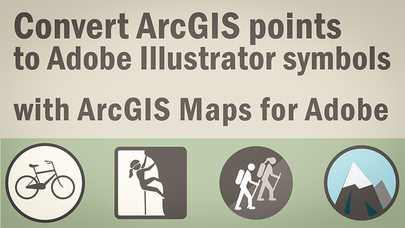
- More ArcGIS symbols—The new World Navigation Map (Places).ai symbols library, which is included with your download when you install the extension, includes vector icons for all the place symbols from the World Navigation Map (Places) basemap. Place symbols represent hospitals, airports, beaches, and many more types of places. You can find the library in the Adobe Illustrator files under Presets > en_US > Symbols > ArcGIS Maps. Use the Symbols process to replace raster symbols with vector point symbols.

- Improved AIX post-processing—Opening .aix files and replacing brushes, symbols, and swatches run much faster.
- Callout symbols appear in their own layer—If you open an .aix file that includes callout text symbols, those symbols now appear in their own sublayer in the halos layer.

Bugs fixed with the May update
- Fixed a bug that caused labels with Japanese characters and line breaks to rotate unexpectedly in AIX exports (BUG-000173024).
- Fixed a bug that caused characters in vector tiles written vertically (top to bottom) to appear written horizontally (left to right) in AIX exports (BUG-000172851).
- Fixed a bug that caused polygon features with shape marker fill symbology in ArcGIS Pro to display the fill to the extent of rectangular bounding boxes instead of the polygon outlines in AIX exports (BUG-000175363).
- Fixed a bug that caused image point symbol callouts to be missing and map frames to appear blank in AIX exports (BUG-000173638).
- Provided workarounds for a bug that causes Maps for Adobe Creative Cloud version 3.8 to not start when installed with Illustrator version 29 (BUG-000175581). To avoid this bug, install the extension using per-machine configuration or on an English version of Illustrator.
Announcements
Maps for Adobe Creative Cloud at UC 2025
The Esri User Conference returns to San Diego in July. This year’s conference has over 700 sessions, including over 200 technical sessions. If you’re looking to start building your schedule, we recommend the following presentations being given by our team. Session times are provided in Pacific Daylight Time (PDT).
| Title | Presenters | Type | Level | Access Type | Dates & Times | Room in SDCC |
|---|---|---|---|---|---|---|
| ArcGIS Maps for Adobe Creative Cloud: Building Engaging Graphics | Ashley Kuhn and Derick Mendoza, Esri | Demo Theater Presentation | Beginner | In-person | Tuesday July 15th @ 1:00pm-1:45pm | Expo Demo Theater 5 |
| ArcGIS Maps for Adobe Creative Cloud: Collaborative Map Design Workflows | Ashley Kuhn and Julia Olson, Esri | Technical Session | Beginner | In-person, Recorded | Tuesday July 15th @ 4:00pm-5:00pm | Room 16A |
| ArcGIS: Designing Thematic Maps | Ken Field, John Nelson, and Lauren Tierney, Esri | Technical Session | Beginner | In-person, Recorded, Live stream | Wednesday July 16th @ 1:00pm-2:00pm | Thursday July 17th @ 2:30pm-3:30pm | Ballroom 20D | Room 1B |
Functionality deprecation
The May 2025 (3.9) release of ArcGIS Maps for Adobe Creative Cloud is the final version to support the following things:
- The Add Demographic Data tool
- Adobe Photoshop
Future development will focus on supporting ArcGIS and Adobe Illustrator workflows.
The next update will be a major one. We’ll introduce a new version of Maps for Adobe Creative Cloud with a modernized interface aligned with other ArcGIS applications.
Read more in the announcement blog post.
More information
For more about what’s new, see our documentation.
Do you have any thoughts about our new features? Let us know on Esri Community.
Download the latest version of Maps for Adobe Creative Cloud.
Happy spring!
The ArcGIS Maps for Adobe Team


Article Discussion: