What’s new in ArcGIS for Microsoft
The latest releases across ArcGIS for Microsoft bring new ways to analyze, visualize, and manage location data directly within Microsoft workflows. Updates across ArcGIS for Microsoft 365, ArcGIS for Power Platform, and ArcGIS for Microsoft Fabric give users greater control over spatial analysis, simplify workflows, and make it easier to bring geographic context into everyday work.
Quick Links
ArcGIS Maps for Microsoft Fabric
ArcGIS for Teams and ArcGIS for SharePoint
ArcGIS for Microsoft Fabric
ArcGIS Maps for Microsoft Fabric
Gain location intelligence directly in Microsoft Fabric
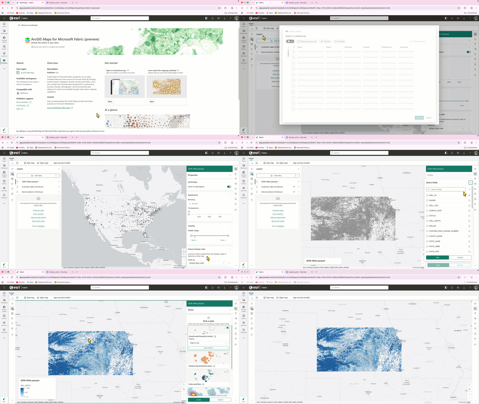
ArcGIS Maps for Microsoft Fabric is now generally available, bringing ArcGIS location intelligence directly into Microsoft Fabric. Users can visualize OneLake data alongside Esri business, demographic, lifestyle, environmental, and other spatial data to add geographic context and uncover patterns that may not be apparent in tables and charts alone.
ArcGIS Maps for Microsoft Fabric is included with ArcGIS Online and ArcGIS Enterprise user types, with capabilities aligned to user type. Viewer or higher users can open and view maps, while Creator or higher users can work with their own Fabric data and create and save maps.
Additional updates expand the mapping experience with more than 2,500 ready-to-use symbols, enhanced label and layer styling, improved category search and filtering, cluster styling, a carousel layout for pop-up attachments, and support for multipoint sketch features.
ArcGIS for Power BI
Continue analysis with improved Find Similar results
The Find Similar tool in ArcGIS for Power BI is now more intuitive and allows results to be exported as a separate layer, making it easier to continue analyzing locations that share similar characteristics. For example, after identifying locations similar to a high-performing site, users can export the results and run drive-time analysis to compare accessibility and potential customer reach.
Map and analyze data in the coordinate system that fits your work
ArcGIS for Power BI now supports custom spatial references, allowing users to work in a coordinate system suited to their data instead of relying solely on Web Mercator. This provides greater flexibility and accuracy, particularly when analyzing large or high-latitude regions where Web Mercator can introduce greater distortion. For example, a customer mapping assets across Alaska can use a coordinate system suited to the region instead of Web Mercator, avoiding these distortions and ensuring measurements reflect real-world conditions for more accurate spatial analysis.
ArcGIS for Microsoft 365
ArcGIS for Excel
Focus proximity analysis on the features that matter
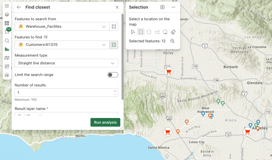
ArcGIS for Excel now lets users select specific map features as the input for Find Closest, providing greater control over proximity analysis. This enhancement provides greater control over the analysis and helps users focus only on relevant features instead of analyzing the entire dataset. For example, a utility company can select affected customer locations and identify the closest field crews or service facilities without analyzing the entire dataset.
Sketch and annotate directly on the map
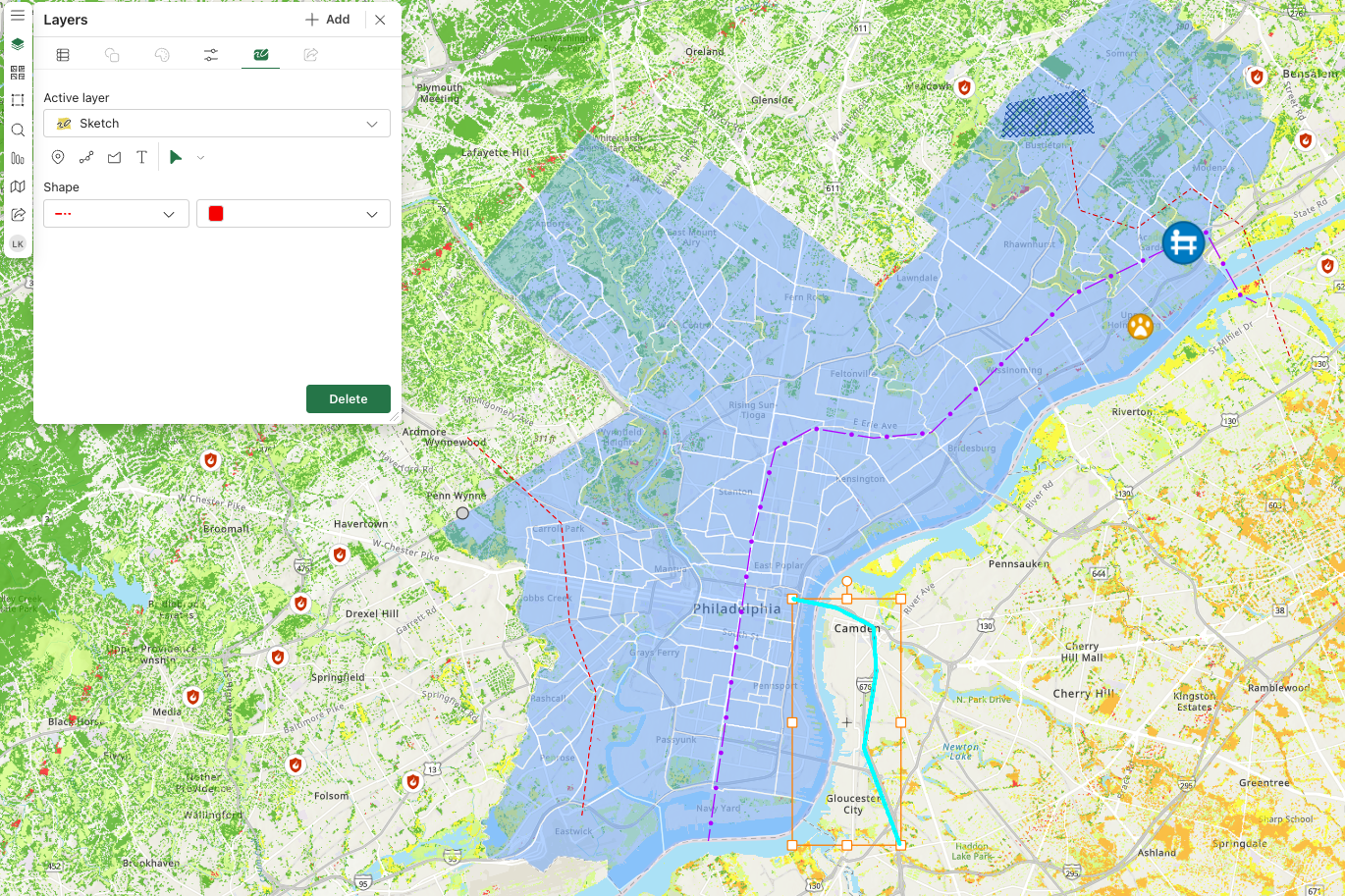
Users can now draw and annotate directly on the map in Excel using sketch graphics. After sketching on a feature layer, users can save the sketch layer together with the feature layer as a web map, making it easy to preserve and share geographic context with others. For example, a commercial real estate team evaluating potential development sites can draw proposed site boundaries, access corridors, or areas of concern and save the annotated web map for stakeholders to reference during site-planning discussions.
We want to hear from you!
Share your experience using ArcGIS for Excel, including how you use it in your workflows, any challenges or limitations you’ve encountered, and opportunities where we can improve. Your feedback will help us better understand your needs and guide future enhancements to the overall experience.
ArcGIS for Teams and ArcGIS for SharePoint
Bring GIS data directly into Teams and SharePoint
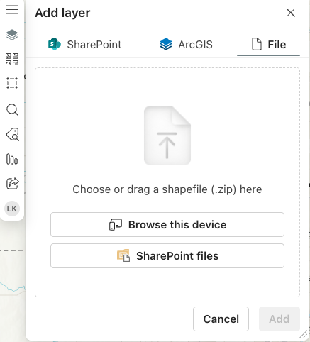
Users can now add shapefiles containing geographic features, such as boundaries, roads, or other mapped locations, directly from a Teams channel’s Files tab into ArcGIS for Teams. Rather than simply viewing the data, users can use the shapefile to create a SharePoint list or an ArcGIS feature layer for use in their spatial workflows. Shapefiles can also be uploaded directly to maps in ArcGIS for SharePoint. For example, an emergency management team can bring a shapefile containing updated evacuation zones into Teams and create an ArcGIS feature layer to use the data for ongoing planning and coordination.
ArcGIS for Power Platform
Connect to more ArcGIS environments with one connector
ArcGIS Connectors for Power Automate now supports ArcGIS Enterprise in addition to ArcGIS Online and ArcGIS Location Platform, simplifying connection management for organizations working across ArcGIS environments. For example, an organization using both ArcGIS Online and ArcGIS Enterprise can access services from either environment without managing separate connectors.
Automate responses to changes in ArcGIS content
ArcGIS Connectors for Power Automate now supports webhooks for portal administration, making it easier to monitor and manage changes to ArcGIS portal content. ArcGIS Enterprise administrators can create automated flows based on activities such as items being deleted, shared publicly, or commented on, so they can take immediate action instead of manually checking for updates. For example, an organization can create a flow that automatically notifies administrators when an item is shared publicly, helping them stay informed of changes that may require attention.
Monitor multiple feature service changes with one trigger
The ArcGIS Connectors for Power Automate triggers can now listen for multiple types of changes to a single feature service, reducing the number of flows organizations need to create and manage. A single trigger can monitor changes such as features being added or deleted, attachments being added or deleted, and attribute updates, ensuring no critical changes are missed. For example, when field crews make different types of updates to a layer, organizations can use one trigger to send notifications for specific changes rather than creating and managing separate flows for each one.
Additional Resources
These updates across ArcGIS for Microsoft focus on simplifying workflows, expanding spatial analysis capabilities, and giving users more flexibility to work with location data directly within familiar Microsoft applications.
To get the most out of these capabilities and stay updated, explore our additional resources, including the Esri Community pages for ArcGIS for Microsoft 365, ArcGIS for Power Platform, ArcGIS for Microsoft Fabric, as well as the ArcGIS for Microsoft product page.

Commenting is not enabled for this article.