ArcGIS Pro Intelligence is designed for intelligence professionals to visualize, explore, and analyze disparate data to produce actionable intelligence. Exploring data from multiple sources (including Esri business partners like MAXAR) and perform advanced analytics such as spatial, temporal, statistical, predictive, and relational gives us exceptional ways to uncover key answers to questions.
ArcGIS Pro Intelligence provides tools to directly connect to your data and integrate data from Esri business partners. Seamlessly we can bring data into ArcGIS from web services, spreadsheets, unstructured documents, and more. Users can then visualize their data in 2D or 3D maps, link charts, timelines, tables, and graphs, and more. Often users are asked to find solutions to complex questions of their data using a variety of analytical techniques to uncover patterns, trends, forecasts, correlations, and relationships.

Leveraging relevant and timely data from Esri business partners, like MAXAR’s 3D Data, enables Esri users to perform interactive viewsheds and understand the circumstances from multiple perspectives, including air, ground, or specific locations in ArcGIS Pro Intelligence. Additionally, we can integrate Full Motion Video (FMV) files and identify key anomalies we wouldn’t see otherwise, like understanding where vehicles might be that are outside a building’s viewshed using MAXAR’s high quality 3D data.
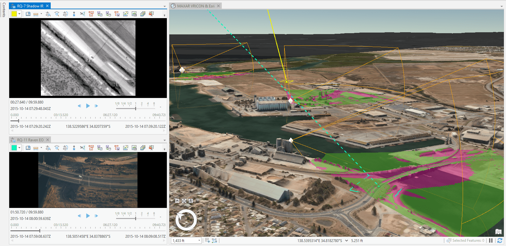
Using FMV in tandem with MAXAR’s 3D data enables users to analyze video data quickly and easily from multiple perspectives. For example, users can view both the FMV perspective viewpoint and the viewpoint of someone on the ground who is identifying the vehicle’s position and visibility.

ArcGIS Pro Intelligence enables users to seamlessly integrate a variety of data from multiple sources in one operating environment to inform smarter operations. As shown in this example using MAXAR’s 3D data inside ArcGIS Pro Intelligence, users understand the viewpoint, obstructions, and the gaps in coverage for situational awareness. As such, 3D models provide a view most of us don’t know without this visual analysis, especially when we’re using datasets that show locations on the other side of the world.
The geospatially enabled characteristics of FMV and MAXAR’s 3D data enable ArcGIS Pro Intelligence users to conduct forensic analysis for situational awareness and smarter decision making.
To learn more about ArcGIS Pro Intelligence, access on-demand training, videos, and additional resources, visit the ArcGIS Pro Intelligence website at go.esri.com/arcgis-pro-intelligence. Be sure to learn more about FMV at Esri at www.esri.com/fmv.


Commenting is not enabled for this article.