by Laurie Williams, Senior Planner/Watershed GIS, County of Marin, CA
 The Department of Public Works of Marin County, CA (just north of San Francisco, CA) launched a watershed program to integrate flood protection, stream and wetland habitat restoration activities, fish passage, and water quality improvements. Instead of looking at flooding issues on a site by site basis, we solve flooding problems at a watershed scale, and employ solutions such as habitat restoration to reduce flood risks.
From the outset, we decided to base our stakeholder outreach, collection of scientific studies and technical reports, and dissemination of information from the Marin County Watershed Program website (http://www.marinwatersheds.org) in order to save paper resources, be more user-friendly, support community outreach and more efficiently advertise our updates than is possible with more traditional printed reports and documents.
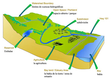
Our website is the major repository of meeting notices, posted reports, and maps. Our website designer, Athena Design, chose a color palette to enhance and reflect the colors of nature: the blues of water, the greens of plants, and browns for earth tones; orange splashes complement the dominant blue. We use the palette extensively in producing the watershed maps, as well as for printed materials and PowerPoint presentations for a unified design.
Watershed Explorer
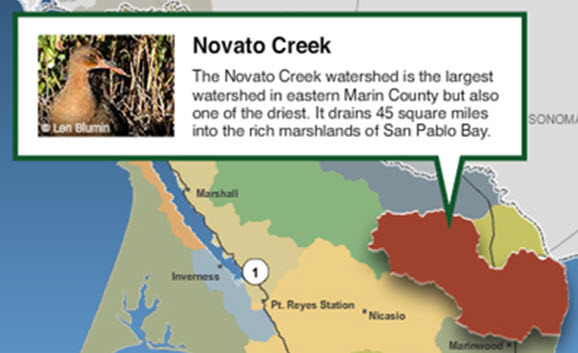
The Watershed Explorer page is the entry point for learning about existing conditions in each watershed in the county. The page features a watershed map with a hover function created in Adobe Flash, which pops up a watershed-specific photo and text snippet when you hover over a watershed on the map. Clicking on the watershed itself leads to informational pages about that watershed, with thematic maps and local information about the natural flora and fauna, cultural history, and land use. We want residents of the watershed, students, and others to use these pages to discover new facts about where they live.
Flood Protection and Watershed Programs
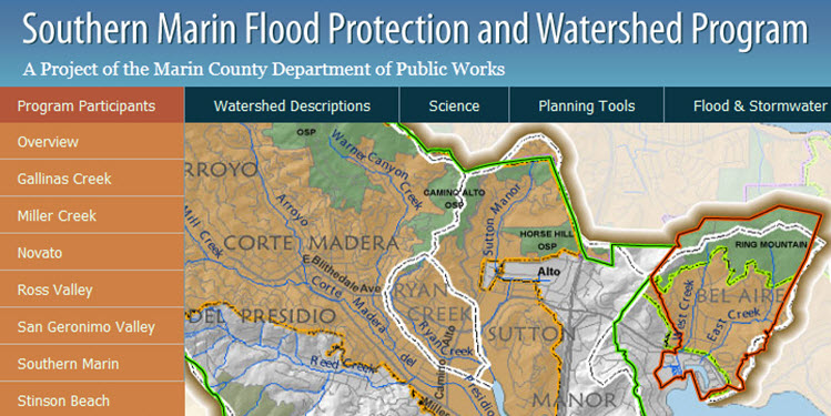
Currently, we have six active Flood Protection and Watershed Programs, each of which has its own page on the website. Each program is a collaboration of local jurisdictions, water agencies, parks and open space districts, friends of creeks groups, and other interested and invested citizens and stakeholders. These programs, which are just getting under way, will include hydrology and hydraulic studies, stormwater master plans, potential impacts of sea-level rise, habitat assessments, and infrastructure inventory and capital improvement planning. These studies and plans will be posted to the website for citizen and stakeholder review and will lead to the identification of multi-benefit projects that can better compete for State and Federal funding.
GIS and geospatial data will play a central role in the analyses and mapping. While some of the H & H studies will be conducted by consultants using proprietary software, others may be done in house using HEC-GeoRAS and HEC-GeoHMS. We are using recently-flown LiDAR data to create DEMs and DTMs for model inputs.
Our projects will need to be resilient to sea level rise. We are looking at various sea level rise scenarios (efforts by USGS, SF Bay Conservation and Development Commission, PRBO Conservation Science, etc.) and the possible effects on flood control facilities and sensitive species’ habitats.
Program Status and Next Steps
To date, summaries of existing conditions and lists of historic reports and studies have been completed. H & H studies and DEM development are complete or underway in four of the watersheds. Stakeholder groups have begun meeting. Some of the programs are more involved than others; some will be complete by the end of 2012, while others will continue through 2015 (not including project implemention).
The website continues to develop as our watershed work progresses. Some of our longer term options to improve the website include:
- Creating interactive maps to highlight facilities, project locations, and species presence
- Posting interactive hydrology and hydraulic models as they are developed
- Incorporating ArcServer-based mobile apps for field staff
Special thanks to Laurie Williams for providing this post. Questions for Laurie: lwilliams@marincounty.org

Article Discussion: