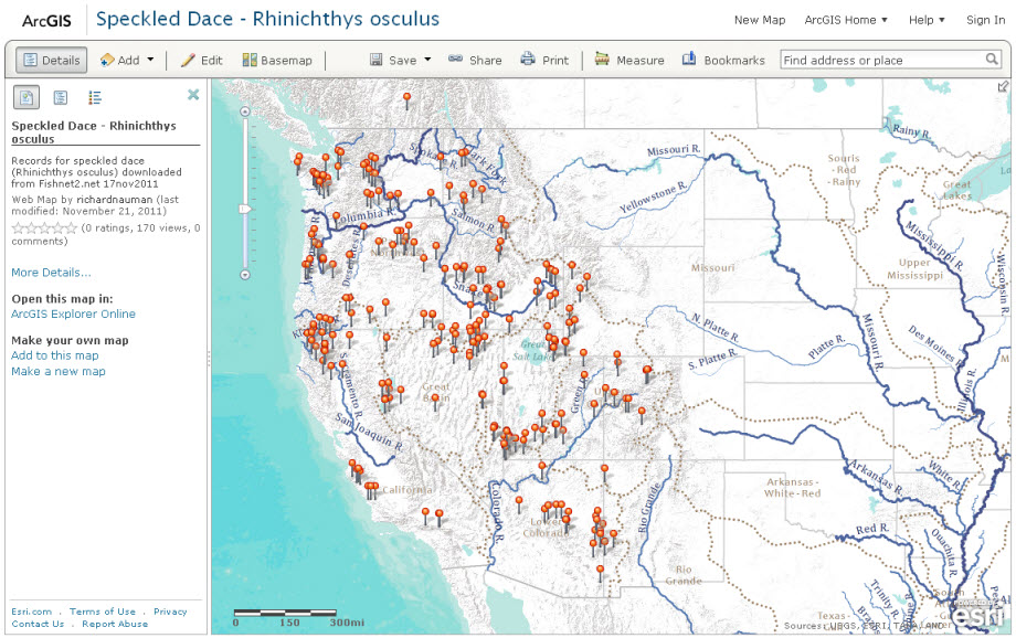
Aquatic biologists and other researchers often need to make and share maps with simple point locations. ArcGIS Online and the Hydro Reference Overlay together make a great platform for mapping and sharing museum records for aquatic species.
Information on species localities is available from a variety of sources. One particularly useful site, VertNet, provides open access to over 84 million museum records from 72 vertebrate collections. The data are shared through 4 distributed database systems – MaNIS (mammals), HerpNET (reptiles and amphibians), ORNIS (birds), and FishNET (fish).
To produce a map of records for one of my favorite fish, the speckled dace (Rhinichthys osculus), I searched for it by scientific name on FishNet and downloaded the records as a csv file. I opened a new map in ArcGIS.com and dragged the csv file onto the map.
I switched to the terrain base map and added the hydro reference layer to provide an easy to understand reference map with features relevant to aquatic species (see below for details on how to add these layers). I then configured the pop up window and marker symbols and saved the map. The entire process took less than 2 minutes. Early in my career it took weeks to make a simple static map of museum records. The advent of web access to georeferenced collections information makes producing web maps rapid and easy.
http://www.arcgis.com/home/webmap/viewer.html?webmap=7b00561e90fb4799a3b30a235ec26f9f
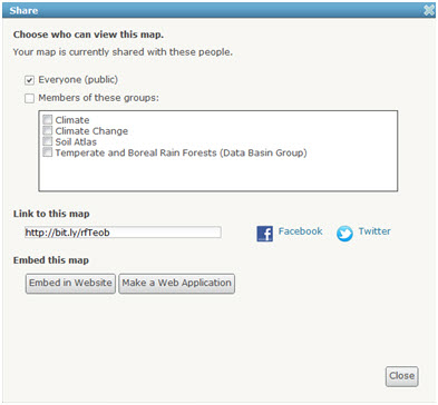
Once a web map is created in ArcGIS.com and saved it can be shared in a variety of ways. Click the “Share” button at the top of the web map to access these options. You can share the map with everyone or only with members of ArcGIS.com groups. The share window provides a short link you can email, Facebook and Twitter links, and code that you can embed in your own website. Additionally you can select “Make a Web Application” to build your own application using one of the hosted templates.
To make an application:
Click “Share”, check “Everyone”, and then click “Make a Web Application”
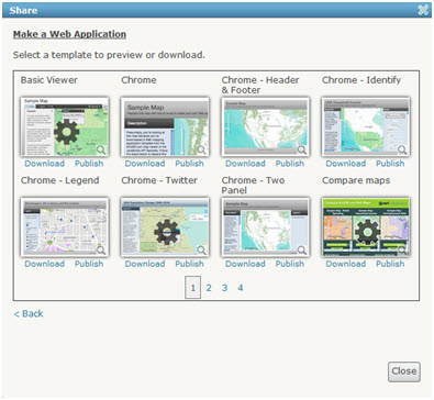
Select a template and click “Publish”. Give the application a title in the next window. Then go to the details page for the application from “My Content” and share and configure the application.
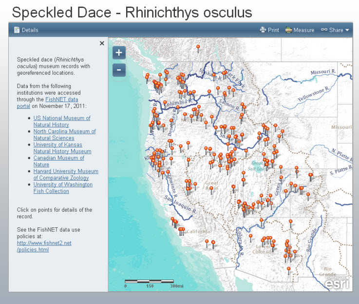
The details section of the application is populated from the details field of the webmap. Here I’ve included appropriate references to the data sources.
http://apps.arcgis.com/hosted/OnePane/basicviewer/index.html?appid=0c4a4a3f7ca04f4b8ae89745524622a1
Additional Information
To add the terrain base map and hydro reference layer:
- Click the “Add” button and then select “Add Layer from Web”
- Paste the link to the terrain base map into the “URL” box
- Repeat the process with the hydro overlay url
URL for terrain basemap:
http://server.arcgisonline.com/ArcGIS/rest/services/World_Terrain_Base/MapServer
URL for hydro reference layer:
http://hydro_bm.esri.com/ArcGIS/rest/services/Hydro/HydroReferenceOverlay_MXD/MapServer
Useful link for getting started:
http://www.esri.com/software/arcgis/arcgisonline/videos.html
Special thanks to:
FishNET for providing data access and to the following museums for making their data available:
US National Museum of Natural History
North Carolina Museum of Natural Sciences
University of Kansas Natural History Museum
Canadian Museum of Nature
Harvard University Museum of Comparative Zoology
University of Washington Fish Collection
For more information on using biodiversity data in ArcGIS.com web maps and applications contact Richard Nauman (rnauman@esri.com).

Commenting is not enabled for this article.