If you were to install the latest version of ArcGIS QuickCapture (and you should), you would not see much of a difference at first sight: this version is 100% compatible with your existing projects and the app user experience remains untouched. This update, however, is a big jump forward in terms of quality and ways to improve your field data collection workflows. Here is why:
A more robust and dependable mobile app
The use of ArcGIS QuickCapture to support field data collection is growing quickly. Over the past 3 months we have worked very closely with organizations deploying QuickCapture at large scale: to support COVID-19 related efforts, in response to natural disasters, for routine asset maintenance and inspections, in conservation projects and other initiatives of all sorts. Through this collaboration, we found ways to make the mobile app more reliable and robust.
QuickCapture now manages varying network conditions better than ever before. The app handles situations where network connectivity is poor or unreliable, and recovers from data upload failures without user intervention. This update also brings better memory management, allowing you to capture more data simultaneously and over longer periods of time.
More project configuration options
A handful of enhancements have been added to QuickCapture designer, the web experience for building and managing your QuickCapture projects.
- Free text entry in project user input lists: project user inputs are used to get information from the field user before the data collection starts. This information can then be used to automatically enrich the attributes of collected observations. For example, a project user input can be defined for the field user to specify a Field Crew ID, the ID of the pipeline or area to be inspected, a charge code, road number, etc. As data is collected, this information can be added as an attribute to new records created without further intervention by the user. You can now define Project User Inputs as a closed predefined list of choices or alternatively leave the list open so end users can enter additional values not present in the original list.

- Change the size of button labels: from QuickCapture designer, you can now control the size of labels in your buttons. Take pride in your QuickCapture project designs. Small details like this matter to field users.

- Pass the current location of the device to a Survey123 smart form: we introduced the concept of link buttons in our previous update. Add link buttons if you want field users to launch other apps from QuickCapture. For example, you can open a web app, such as dashboard or a web map. Or open an instruction manual or play a video. You can also launch native apps in your device, like ArcGIS Survey123. You can now pass your location as well as other information to prepopulate questions in your Survey123 smart forms.
")
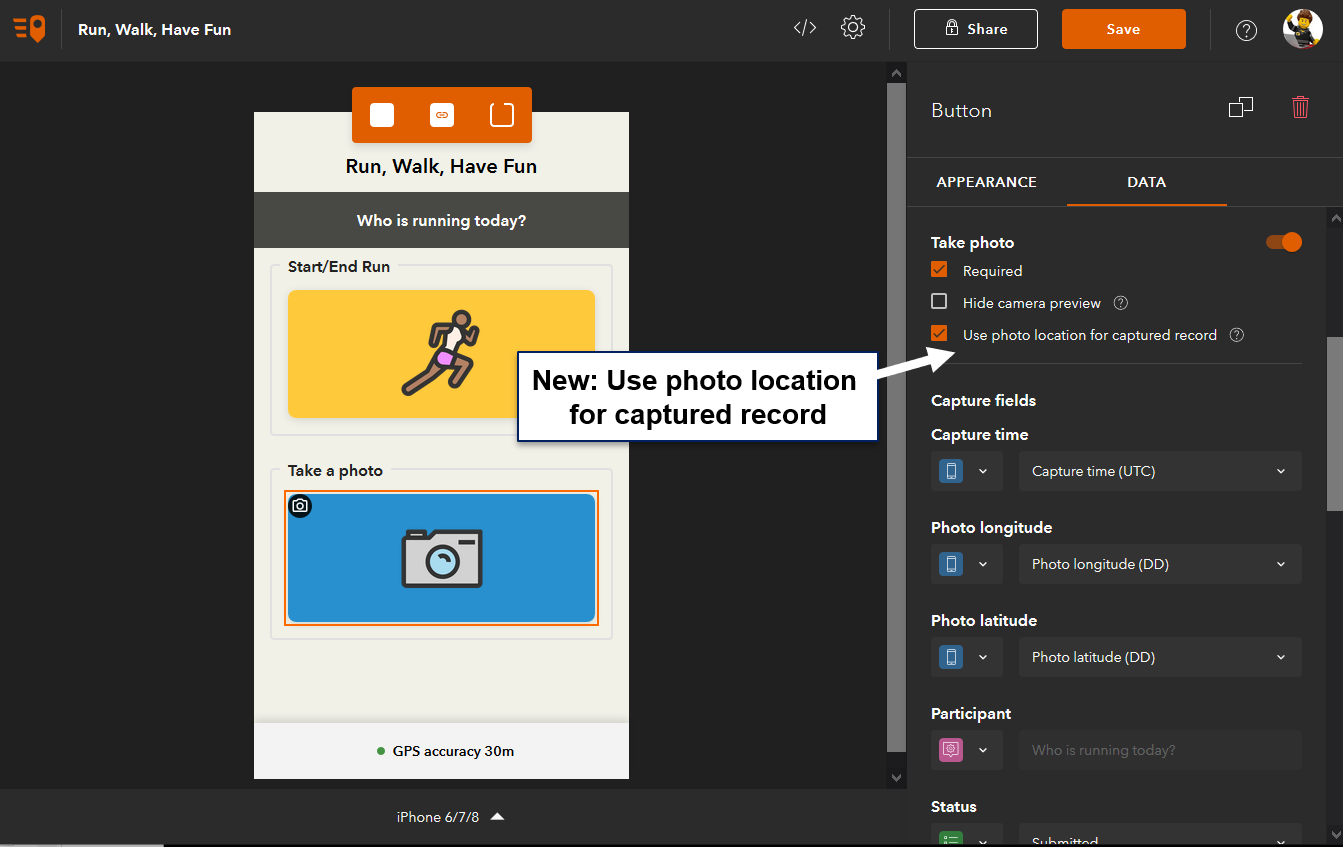
- Use photo location for captured record: In some workflows, you will want to capture the location of an object first, then take a few steps back and snap a photo of the object. In other cases, you may want to keep the exact location from which you take the photo, as the location of your observation. With QuickCapture designer, you can now decide what works best for you: A new option in designer lets you use the location of a photo as the location of a captured record.
- New device variables: Device variables let you automatically populate attributes in records you collect with QuickCapture. Here is a list of some device variable recently added:
- Photo: Heading, Pitch, Roll
- Location: MGRS, USNG, DDM, DMS
- QuickCapure app version and Operating System version
- Line length and polygon area
All the above enhancements in QuickCapture designer will help adjust your projects to the specific needs of your field data collection workflows. Give yourself some time to explore these different options as they can make a difference to field users.
Project templates
Project templates allow you to kick-start your own projects from a list of predefined fully functional projects. You can use these templates as-is or tailor them to your needs. In this release we have added a few new templates:
- Occupancy Counter: Count the number of individuals entering and exiting a given site with ArGIS QuickCapture.
- Run, Walk, Have fun: Want to organize a virtual race? Use ArcGIS QuickCapture to record participants’ routes and photos along the way.
- Missing-person search operations: This template is an adaptation of the WiSAR project by the National Alliance for Public Safety GIS (NAPSG) Foundation SAR working group.

ou will also note that all the QuickCapture templates include ready to use dashboards and layer views. As an administrator of your organization, you can also configure your own templates for use by other QuickCapture authors.
Oriented Imagery (Beta)
Finally, we are also introducing a new exciting Beta feature with this release: Oriented Imagery. The basic idea here is to enable you to exploit photos taken from the field in a more interactive way, using oriented imagery tools in ArcGIS.
Starting with this version, you can enable your projects for oriented imagery data collection. By doing so, when a photo is taken with the QuickCapture app, a number of attributes (photo location, heading, pitch roll, field of view and more) are automatically stored as GIS attributes. With this information, ArcGIS Oriented Imagery tools in ArcGIS Web AppBuilder (Developer Edition) as well as ArcGIS Pro will let you visualize and query your field collected data in innovative ways. Below is a brief animation showing these tools in action.

Oriented imagery tools let you quickly discover existing photos you may have of existing assets; by clicking on a map. They also help you visualize your photos in a geographic context by projecting on a map the field of view of your photos. Enabling oriented imagery in your QuickCapture projects adds no overhead to field users, but enriches and prepares your field collected data for using these exciting tools in the future.
More resources
If you want to learn more, check our What’s New video below as well as our What’s New in QuickCapture help topic. Over the next few weeks we will post some additional focused articles describing in more depth how to take advantage of some of the features described here.


Article Discussion: