ArcGIS Maps SDK for Unity delivers richer, more detailed 3D visualization with Gaussian splat layers, data-driven styling for point clouds, billboarded symbols for 3D point layers, and enhanced 3D Tiles support that broadens data compatibility while improving performance, visual quality, and attribution compliance.
Gaussian splat layers
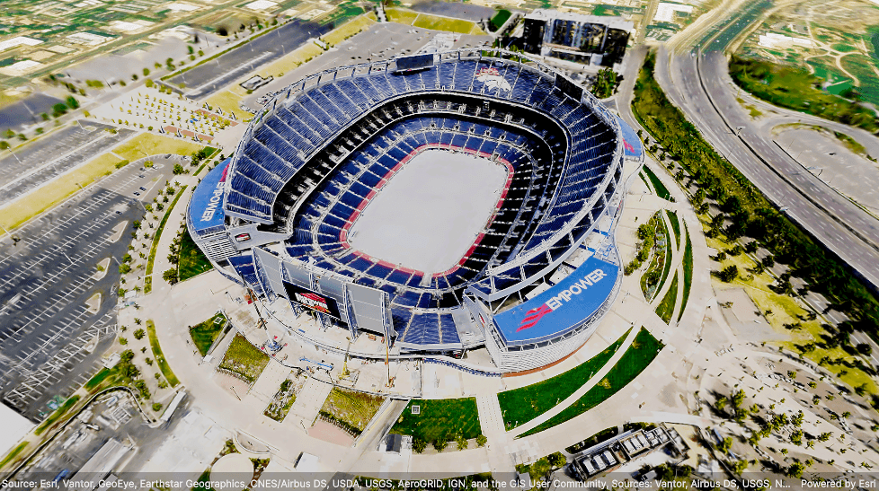
Version 2.4 introduces support for Gaussian splat layers, enabling highly realistic visualization of complex built and natural environments. By preserving fine-grained detail, Gaussian splats are ideal for creating high-fidelity digital twins and visualizing intricate infrastructure, such as utility power lines, industrial pipelines, construction equipment, and plant facilities. They also excel at capturing transparency and reflections in features like glass and metal surfaces while accurately representing vegetation and other natural elements.
Gaussian splatting is a reality-capture technology that reconstructs a 3D scene from millions of dense points, known as splats. Each splat is a soft, ellipsoid-shaped element defined by its position, rotation, size, color, and transparency. Together, these splats create smooth, photorealistic visualizations that can preserve the detail and realism of scanned environments more effectively than traditional mesh-based representations.
Gaussian splat layers can reference web layers published to ArcGIS Online or ArcGIS Enterprise for connected workflows, or they can consume local Gaussian splat content distributed as a 3D Tiles dataset or archive, to support offline, secure, and bandwidth-constrained workflows.
In this release, Gaussian splat layers are supported for use in application built for the desktop platforms Windows, Linux, and macOS). Support for Android and iOS is planned for a future release.
Point cloud layer renderers and filters
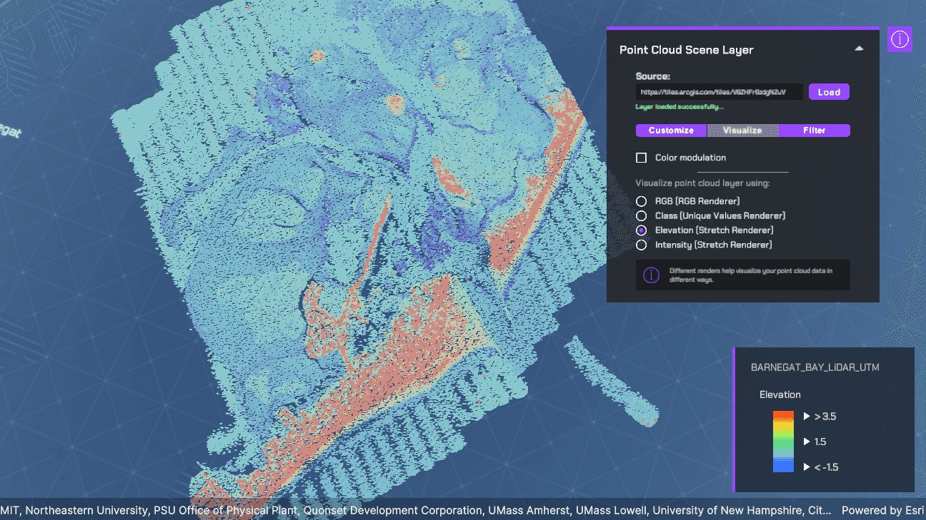
The 2.4 release expands the point cloud layer API, giving developers greater control over how point cloud data is visualized and explored. New renderer options make it easier to highlight meaningful patterns and features within large datasets. Use class breaks renderers to symbolize quantitative attributes, unique value renderers for categorical data, stretch renderers to apply color gradients, or RGB renderers to display color information directly from point cloud fields. You can also adjust point size and apply color modulation to further enhance visual analysis.
New filtering capabilities provide precise control over which points are displayed. Value, return, and bit field filters can be used to isolate points based on attribute values, LiDAR return types, or bit flag classifications. By combining renderers and filters, you can more effectively distinguish and analyze features such as buildings, vegetation, and ground surfaces, enabling richer visualization and interpretation of point cloud data.
3D Point layer marker symbols
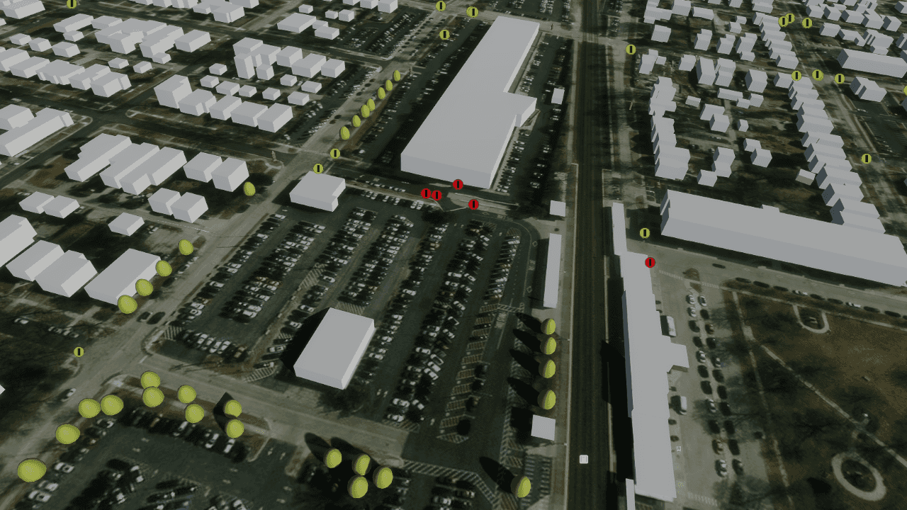
Point scene layers now support 2D marker symbols, expanding the available symbology options beyond the 3D model symbols introduced in the previous release. Developers can visualize point features using billboarded vector and picture markers that automatically orient toward the camera as users navigate a scene, improving visibility and readability in 3D environments.
Support for billboarded marker symbols is available across simple, unique value, and class breaks renderers, enabling more flexible, attribute-driven visualizations. This enhancement complements existing support for realistic 3D model symbols and primitive shapes, giving developers additional options for representing data in scene-based applications. Billboarded marker symbols provide a lightweight alternative to 3D models for visualizing point features in scenes. Because the symbols automatically face the camera, they remain visible and recognizable from any viewing angle, making them well suited for thematic and attribute-driven visualizations. In contrast, 3D model symbols provide realistic representations of real-world objects but can be more difficult to identify at a distance or from certain perspectives.
In this release, support for 2D marker symbols on 3D Point layers is limited to billboarded marker symbols and does not yet include draped or flat markers, text symbols, or labeling.
3D Tiles layers
This release includes several improvements to 3D Tiles visualization, delivering more efficient rendering and higher visual fidelity, while making it easier for developers to work with large-scale datasets, a broader range of 3D Tiles content, and meet attribution requirements.
Enhancements to tile request prioritization now focus on reducing screen space error (SSE) as efficiently as possible, ensuring that tiles with the greatest impact on visual quality are prioritized for loading and rendering. As a result, tiles closest to the camera are typically displayed first, improving responsiveness during navigation and creating more gradual level-of-detail transitions across surfaces, reducing the visual contrast between highly detailed and coarse neighboring tiles.
Rendering and visibility management have also been enhanced through a new world-coverage approach. The layer now maintains complete coverage of the dataset extent by loading all required tiles, including tiles outside the current view frustum. While out-of-view tiles are displayed at the lowest available level of detail to minimize memory consumption, they remain available to eliminate visible gaps when rapidly panning or navigating across a scene. Combined with improved tile edge handling that removes seams between adjacent tiles, these changes deliver smoother, more continuous visualization at regional and global scales and when moving between distant locations.
Additional improvements include altitude offset support for better alignment between 3D Tiles layers and other scene content, as well as enhanced terrain occlusion for more accurate visibility and rendering of scene elements relative to the terrain surface. To improve interoperability with a wider range of 3D Tiles content, this release adds support for additional compressed texture formats for both online and offline datasets, including WebP, DXT1, DXT5, ETC1, and ETC2, along with support for the EXT_meshopt_compression extension for more efficient storage, transmission, and rendering of 3D content.
This release also adds support for dynamic attribution and copyright information. Attribution is automatically derived from the content visible in the current view, aggregated, and exposed through the AttributionText property on ArcGISView. This simplifies compliance with content licensing requirements, particularly for data sources whose attribution changes based on the visible content. Developers using Google Photorealistic 3D Tiles should continue to follow Google’s attribution requirements for applications built with the Google Map Tiles API.
Download and get started
Get the latest version from the Unity Asset Store or to learn more about ArcGIS Maps SDK for Unity visit the Esri Developer website. For more details about the enhancements, deprecations, resolved issues, and known issues in this release, refer to the Release Notes. If you’re new to developing with our SDK, the Get started page provides helpful resources to kick-start your journey.



Article Discussion: