Are you excited to learn more about the cool things that were recently added to your favorite urban planning tool? Set the stage for the new features of the latest ArcGIS Urban release:
- Modify building forms and sketch new ones.
- Define your own metrics to quantify and compare design scenarios.
- Identify and score parcels by running your own weighted suitability analysis.
- Exchange feedback on designs with your collaborators.
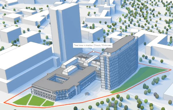
- Conduct interactive shadow impact analysis.
Let’s have a closer look at some of the new capabilities shipped with this release…
Sculpt, sketch, shape
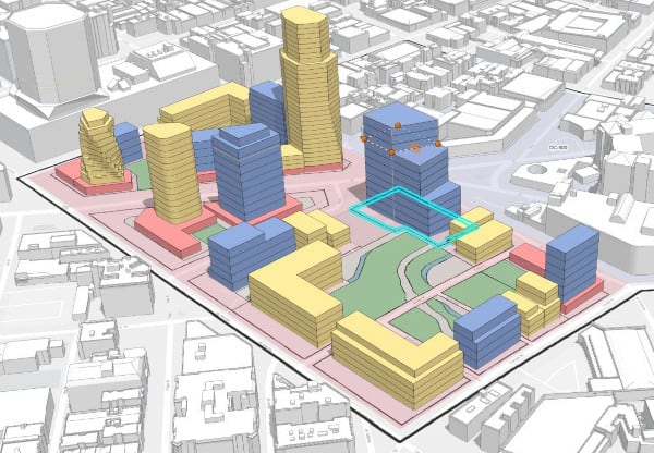
Buildings and space use types are the centerpiece of any scenario within a plan. Starting with this release, you can modify buildings that have been procedurally generated on parcels. You can also sketch buildings from scratch on a selected parcel by starting to draw a new space use. A variety of tools are now at your disposal to ensure a smooth experience. These tools allow you to edit individual vertices of your building floors, push and pull the building walls, rotate building parts, or adjust the elevation of the entire building. As you create building floors you will notice that we also added support for snapping – and as a nice little detail, snapping is now available throughout Urban for editing in general. Besides geometrical edits, you can adjust various building floors attributes such as the space use type, the floor height, and the net area factor. You can also configure on a per floor basis if a floor counts towards the GFA/FAR calculation or not.
This release also introduces surfaces. Surfaces are handled like building floors except that they are draped to the terrain and allow you to model surface parking or green space which will be taken into account when calculating metrics for your scenario.
Evaluate your scenarios using metrics
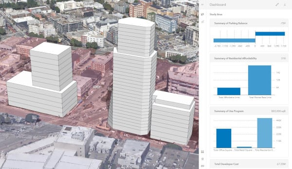
With this release, we have introduced a revolutionary concept for Urban, the ability to create your own metrics. This enables you with the ability to quantify your scenarios and measure what matters most to your design process whether you need to report on ADU capacity, financial feasibility, or just need to balance parking demand. Metrics can be configured based on other metrics, on net space area of surface or building space, or a combination of both. Thanks to the dependency graph you can always keep an overview of how your metrics relate to each other. A new and improved metrics dashboard allows you to report out and visualize metric values in an easy-to-understand way across all of your scenarios. By interacting with the dashboard, you can also visually assess how much a building floor or a surface contributes to a particular metric.
Analyze suitability to validate policy decisions
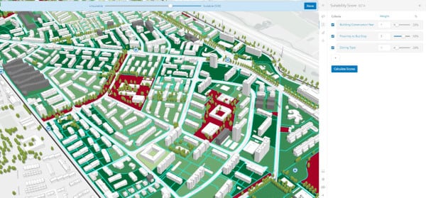
A policy can be any course of action defined to address a problem a city faces, such as housing affordability. With the new parcel suitability tool, released as a beta, you can configure Urban to identify suitable parcels based on the current zoning conditions and potential for new housing development. In addition, new scenarios can be created to test build-out scenarios of the selected parcels. With Urban, you can create more than one suitability model using different variables to drive different redevelopment scenarios. First, you define the criteria relevant to your task. These criteria can refer to attributes already available on the parcels or any external feature layer in ArcGIS Online, which can be dynamically added to your suitability model. Then you can reclassify the selected field and configure a weight for each criterion to fine-tune the calculation of the suitability score. The ability to easily run suitability models will enable cities to be efficient and flexible for this kind of analysis and build-out modeling.
Improved collaboration on designs
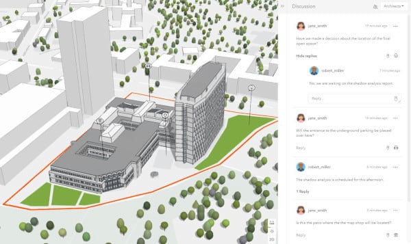
Exchanging thoughts and a vivid discussion are important when collaborating on planning scenarios. The new sharing and discussion functionality accounts for the importance of communication during the design process. Configure with whom you want to share your designs and set up an individual discussion channel for each group of stakeholders. Reply to earlier comments of your coworkers or add new ideas for a design as you are evaluating it. Articulate your comments and thoughts more precisely by dropping them on a specific location in the design. This new feature is powered by the ArcGIS Hub Discussions API.
Interactive shadow analysis
The balance between shadow and sunlight plays an important role in the livability of urban space. Some city regulations dictate that on a given parcel there must be sunlight for a certain amount of hours. Other regulations restrict how long a particular building is allowed to cast a shadow on another building or nearby park. Do you want to find out which areas don’t get any direct sunlight for a certain amount of time in a defined period? Do you need to know for how long a proposed new playground will be in the shadow on a summer afternoon? The newly introduced shadow duration tool helps you to quickly answer questions like these.
Get started today!
With the latest release of Urban, we’ve also updated our popular Getting Started with ArcGIS Urban blog. This short tutorial is a great way to become familiar with sketching new buildings, creating a new metric, and conducting an interactive shadow analysis.
Learn more
This is just a selection of the new features shipped with the July 2021 release of ArcGIS Urban. On top of these features, you now have a new dark mode user interface, additional administrative settings within plans, and the ability to manage the data within plan scenarios. Check out our release notes to make sure that you don’t miss any new features, improvements, and bug fixes.
Want to see these new features live in ArcGIS Urban? Please feel free to schedule a demo with our team or play around with it yourself in a trial version.

Article Discussion: