The 2025 Esri User Conference is just around the corner, and we’re excited to spotlight the powerful capabilities introduced in the 2025 Network Management Release for the ArcGIS Utility Network. This is your chance to dive into the latest tools and take a sneak peek at what’s on the horizon for Utility Network users.
With so many sessions centered around implementing and optimizing the ArcGIS Utility Network, it can be tricky to know where to start—but we’re here to help. In this blog, we’ve handpicked some must-see presentations tailored to your interests, along with helpful resources at the end to get you conference-ready. You will find all the sessions described in this article in the ArcGIS Utility Network custom agenda on the conference website. If you log into your Esri account on the conference website, you can use this custom agenda to quickly add or favorite sessions on your conference agenda, allowing them to show up in your agenda in the Esri Events app.
This guide focuses specifically on ArcGIS Utility Network content. If you’re also exploring broader utility industry topics, don’t miss the industry-specific flyers linked below for additional sessions and events.
Agenda

Esri Showcase
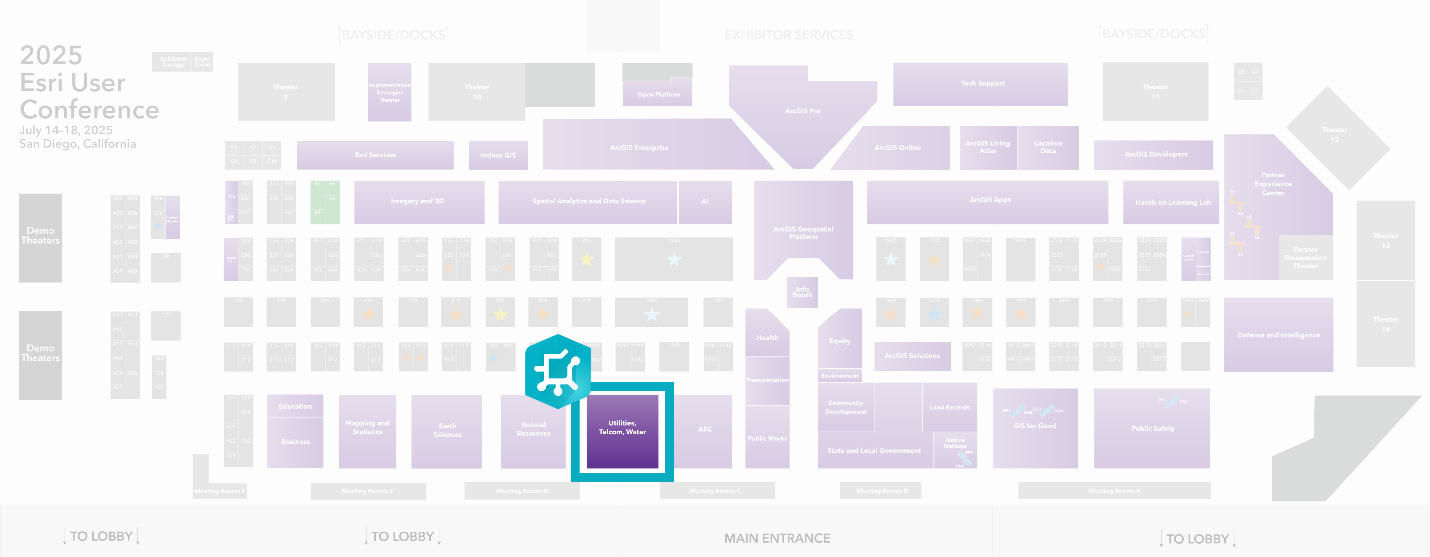
Stop by the ArcGIS Utility Network booth at the Utilities Industry Island on the Expo floor! Our team of experts will be there to walk you through live demos, answer your questions, and share insights into the latest product capabilities.
Showcase hours
- Tue, July 15: 9:00AM — 5:00PM
- Wed, July 16: 9:00AM — 5:00PM
- Thu, July 17: 9:00AM — 4:00PM


Tuesday, July 15
Join the ArcGIS Utility Network product team on Tuesday for both beginner and advanced sessions on ArcGIS Network Management. Can’t make it the first time? No worries—each session will be offered again later in the week.
In addition, the Demo Theater will feature a variety of presentations to help you understand the Utility Network across telecom, electric, and water domains. You’ll also hear directly from gas, electric, and water utilities as they share their real-world experiences implementing the Utility Network.
Technical Workshops
- 10:00 AM – 11:00 AM: ArcGIS Utility Network: An Overview
- 1:00 PM – 2:00 PM: ArcGIS Pipeline Referencing: An Overview
Demo Theater Presentation
- 2:30 PM – 3:15 PM: ArcGIS Data Reviewer: Improving Data Quality for Water Utilities
User Presentations
- 10:00 AM –11:00 AM: Facilities & Vertical Asset Management (City of Baltimore, SCV Water)
- 2:30 PM – 3:30 PM: ArcGIS Utility Network: Moving Past Implementation (Central San, CAESB)
- 2:30 PM – 3:30 PM Modern Gas Network Management (NiSource)
Special Interest Groups
- 11:30 AM – 12:30 PM: Gas Utility & Pipeline SIG
- 11:30 AM – 12:30 PM: Rail SIG
- 11:30 AM – 12:30 PM: Telecommunications SIG
Other Activities
- 7:30 AM – 8:15 AM Telecom Kick-off Meeting
- 7:30 AM – 8:15 AM Electric & Gas Kick-off meeting
- 6:00 PM – 9:00 PM Water Team Social
- 6:00 PM – 9:00 PM Electric, Gas & Telecom Social

Wednesday, July 16
Wednesday offers a full slate of sessions tailored for utility professionals looking to deepen their understanding of the ArcGIS Utility Network. Whether you’re interested in advanced network management, taking networks into the field, or hearing about real-world implementations from leading utilities, there’s something for everyone.
From technical workshops and demo theater highlights to special interest group meetups and social events, Wednesday is packed with opportunities to learn, connect, and explore practical solutions
Technical workshops
- 8:30 AM – 9:30 AM: ArcGIS Solutions: Utility Networks
- 10:00 AM – 11:00 AM: ArcGIS Utility Network: An Overview
- 4:00 PM – 5:00 PM: ArcGIS Utility Network: Advanced Network Management
- 4:00 PM – 5:00 PM: ArcGIS Field Maps: Taking Utility Networks to the Field
Demo Theater Presentations
- 10:00 AM – 10:45 AM: Essential Network Diagram Workflows
- 2:30 PM – 3:15 PM: Tracing Utility Networks in Water and Sewer Scenarios
User Presentations
- 8:30 Am – 9:30 AM: Modernizing Pipeline GIS (Southern Star, ONEOK, Inc)
- 2:30 PM – 3:30 PM: Enhancing Wildfire Monitoring and Risk Mitigation with GIS (Bonneville Power Administration, Tennessee Valley Authority)
- 2:30 PM – 3:30 PM: Solutions for Storm water: Planning and Enhancing Flood Resilience (County of San Diego, City of Virginia Beach)
Special Interest Groups
- 11:30 AM – 12:30 PM: AEC SIG
- 11:30 AM – 12:30 PM: Water Utilities SIG
- 11:30 AM – 12:30 PM: Electric Transmission SIG
- 11:30 AM – 12:30 PM: Electric Distribution SIG
Other Activities
- 6:00 PM – 9:00PM: AEC Social
- 6:00 PM – 9:00PM: State & Local Government Social

Thursday, July 17
Thursday’s agenda offers a focused lineup of sessions for those exploring digital transformation, data quality, and utility network migration. From technical deep dives to customer-led presentations, you’ll gain practical insights into Esri’s modern network management tools. Whether you’re starting your journey or optimizing existing systems, these sessions provide valuable takeaways. Don’t forget to cap off the day by joining the Thursday Night Party—a perfect opportunity to network and unwind!
Technical workshops
- 10:00AM – 11:00 AM: ArcGIS Solutions: Utility Networks
User Presentations
- 10:00AM – 11:00 AM: Digital Transformation with Esri’s Modern Network Management Capabilities (PG&E, MDU)
Demo Theater Presentation
- 10:00AM – 10:45 AM: ArcGIS Data Reviewer: Improving Data Quality for Water Utilities
- 1:40PM – 2:00 PM: Planning for Utility Network Migration: An Overview
Other Activities
- 5:30 PM – 10:00 PM: Thursday Night Party

Additional Resources
If you’re looking for additional resources to check out before or after this year’s user conference, we recommend checking out these additional resources.
If you’re looking for information about the utility network, the Helpful Utility Network Links community document has links to all the most commonly referenced online resources for the ArcGIS Utility Network.
Check out one of the following learning series if you want to explore industry specific collections of utility network related articles, videos, and presentations.
- Learn ArcGIS Utility Network for Electric Utilities
- Learn ArcGIS Utility Network for Gas and Pipeline
- Learn ArcGIS Utility Network for Sewer and Stormwater
- Learn ArcGIS Utility Network for Water Utilities
Use the ArcGIS Utility Network video channel on the Esri Video site to access a curated selection of videos covering utility network content from product releases, webinars, or even past conferences.
You can use the Esri Proceedings site to access the proceedings (slides and videos) from past Esri conferences.
Safe travels, we look forward to seeing you there!


Commenting is not enabled for this article.