ArcGIS LocateXT
Im Benutzertyp "Professional Plus" enthalten
Software zur Entitätenextraktion für die Analyse unstrukturierter Daten
Erschließen von unstrukturierten Big-Data-Beständen
- Entitäten schnell extrahieren
- Workflows automatisieren
- Extrahierte Entitäten kartieren
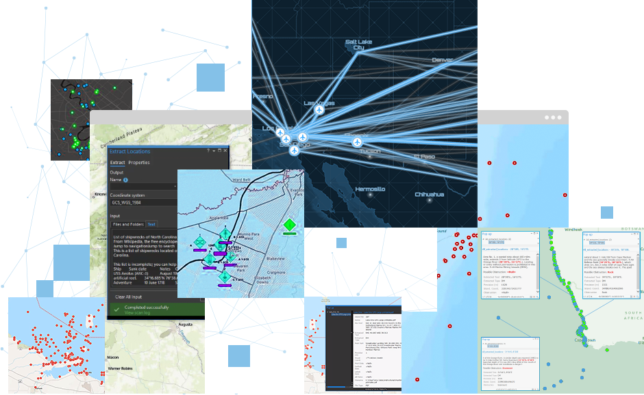
Schnelle Extraktion von beliebigen Entitäten
Extrahieren Sie Positionsinformationen zum Beispiel aus nachrichtendienstlichen Berichten und Social-Media-Posts. Durchsuchen Sie unstrukturierte Daten, und machen Sie Geokoordinaten, Orts- und Datumsangaben, Geo-Tags von Bildern und sonstige entscheidende Informationen sichtbar. Erkennen und extrahieren Sie Geokoordinaten in mehreren Tausend Formaten. Veröffentlichen Sie Ihre Daten in ArcGIS, und analysieren Sie die Beziehungen zwischen den Daten in den ArcGIS Apps.
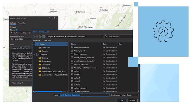
Automatisierung von Workflows zur Entitätsextraktion
Beschleunigen Sie die Generierung und Bereitstellung von Karten, Apps und Berichten. Extrahieren Sie Ihre Daten automatisch in Feature-Classes, Feature-Services, Shapefiles, KML-Dateien und Geodatabases. Sie können benutzerdefinierte extrahierte Attribute erstellen, indem Sie eine Suche mit Schlüsselwörtern und Steuerelemente für die Extraktion konfigurieren. Die bereits verwendeten Attribute werden gespeichert, sodass der Benutzer sie in künftigen Workflows einfach wiederfindet.
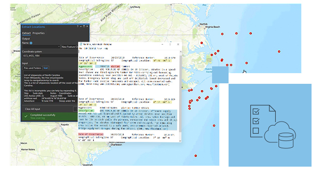
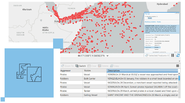
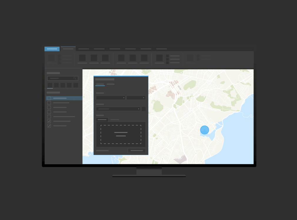
Kartierung von aus Quellinhalten extrahierten Entitäten
Stellen Sie Positionsdaten auf einer interaktiven Karte zusammen mit den zugehörigen Quellinhalten dar. Sie können die extrahierten Positionen erkunden, sortieren und kartieren. Interagieren Sie mit Prätext- und Posttext-Objekten aus den Quellinhalten. Vereinfachen und beschleunigen Sie die Geokodierung von textbasierten Objekten, und verschaffen Sie sich situationsbezogene Erkenntnisse.
Funktionsweise
Daten auswählen
Wählen Sie die unstrukturierten Daten, die Sie analysieren möchten, aus einer Ansammlung von Nachrichten, Berichten, Briefings und Social-Media-Posts Abfragen aus.
Entitäten extrahieren
Machen Sie Positionsnamen und Koordinaten sichtbar, die sich in unstrukturierten Berichten, Social-Media-Posts und sonstigen Quellen verbergen.
Daten auf einer Karte darstellen
Stellen Sie zur strategischen Aufklärung die extrahierten Positionsinformationen gemeinsam mit den Quellinhalten dar.
Workflows automatisieren
Bereits verwendete Attribute werden gespeichert, sodass sich künftige Workflows für die Entitätsextraktion automatisieren lassen.

Weitere Informationen zu ArcGIS
Erhöhen Sie den Wert Ihrer vorhandenen IT-Investitionen: ArcGIS LocateXT installieren und sofort loslegen. Die Software lässt sich vollständig in eine vorhandene ArcGIS-Implementierung integrieren. Bringen Sie künftige Projekte auf der Basis vorhandener Workflows und Systeme schneller an den Start, und senken Sie dadurch Ihre betrieblichen Aufwendungen.
ArcGIS Pro
ArcGIS Pro
Nutzen Sie mit ArcGIS Pro – der Desktop-GIS-Technologie der nächsten Generation – Datenvisualisierungen, erweiterte Analysen und viele weitere Funktionen.
ArcGIS Enterprise
ArcGIS Enterprise
Nutzen Sie ArcGIS Enterprise, die branchenführende Technologie für die Verarbeitung räumlicher Daten.
Dokumentation
Finden Sie Antworten und Informationen, mit denen Sie Ihre Projekte abschließen können.
Vorige
Weiter
Zugriff auf die Funktionen dieser Erweiterung
Im Benutzertyp "Professional Plus" enthalten
Der Benutzertyp "Professional Plus" ist eine umfassende Lizenz, die den Zugriff auf ArcGIS Pro Advanced, die wichtigsten ArcGIS Pro-Erweiterungen und viele andere ArcGIS-Funktionen im Web und auf mobilen Geräten beinhaltet. Mit Professional Plus können Sie umfassende Analysen durchführen, sofort einsatzbereite 2D/3D-Kartografien erstellen, Workflows mit künstlicher Intelligenz (KI) nutzen, benutzerdefinierte Apps erstellen und Ihre Workflows automatisieren.

Die Community kennenlernen
Tauschen Sie sich in der Esri Community mit der ArcGIS LocateXT-Community über Ideen aus, lösen Sie gemeinsam Probleme, und vernetzen Sie sich mit anderen Benutzern.
Austausch mit anderen Nutzer*innen
ArcGIS Blog
Lesen Sie die Artikel des ArcGIS LocateXT-Teams. Setzen Sie sich mit dem Team in Verbindung, um Fragen zu stellen und weitere Informationen zu erhalten.
Den ArcGIS Blog lesen
Kaufoptionen für ArcGIS Pro-Erweiterungen
Telefonischen Kontakt mit dem Vertrieb aufnehmen
1-800-447-9778
7:00 bis 17:00 Uhr Montag bis Freitag (PST)