USER STORY
Location Platform Provides Foundation for Tasmanian Flood Recovery
When floods ravaged large parts of Tasmania in June 2016, geographic information system (GIS) technology ensured that the state's Department of Primary Industries, Parks, Water and Environment (DPIPWE) was ready to act. Government decision-makers and emergency responders on the front line relied on GIS to
- Provide the operations center with accurate, real-time situational awareness.
- Undertake initial rapid impact assessments.
- Rapidly configure specialized apps that supported specific field operations and data collection and analysis tasks.
The advanced location-based analytics platform allowed the capture and provision of detailed, evidence-based impact and damage cost estimates to local, state, and commonwealth governments, helping affected communities secure millions in disaster relief and recovery funding. This data ensured that timely and correct decisions could be made at critical junctures during the flood response and recovery phases to accelerate community recovery.

DPIPWE drew on its existing GIS systems and knowledge base, and expanded upon them to rapidly configure and deploy the tools necessary to support response and recovery efforts.
GIS technology was essential to deliver evidence-based information on the cost of repairs, rebuilds, and debris removals and assisted with securing millions in state and commonwealth assistance for affected communities.
Challenge
The wide reach, rapid onset, and dangerous unpredictability of the June 2016 floods created enormous challenges for Tasmania's emergency services. To minimize the impact on affected communities and speed up recovery efforts, flood damage data was urgently required to inform crucial decision-making.
Initially, a rapid impact assessment was to be conducted to evaluate damage and determine response strategies and to brief government officials and emergency services. However, as recovery costs rose by the millions, the Tasmanian Government recognized that it would need to draw on the federal National Disaster Relief and Recovery Arrangements (NDRRA).
To receive this support, the state had to demonstrate that it met strict criteria relating to both flood damage and recovery costs. This required collecting and presenting comprehensive amounts of data to provide as evidence for the funding application.
Responders and government stakeholders also had to be able to access disaster information in real time without needing any technical training. To ensure that these challenges were met, DPIPWE had to develop a spatial solution that would
- Ensure that frontline personnel could rapidly and efficiently collect and share data from remote and inherently risky areas.
- Allow incoming data from multiple internal and external sources to be fed into the agency's existing common operating picture (COP) to support real-time situational awareness.
- Enable the compilation of specific, reliable, and robust datasets to support a case for commonwealth financial support.
About DPIPWE
DPIPWE is a Tasmanian Government department responsible for the sustainable management and protection of the state's natural and cultural assets.
The department's activities guide the use and management of Tasmania's land and water resources and protect and promote its natural, built, and cultural assets—delivering services that support primary industry development and protect the state's relative disease- and pest-free status.
In addition, DPIPWE is responsible for strengthening emergency management throughout Tasmania—underpinning planning, preparedness, and response and recovery efforts with GIS technology, managed by a dedicated team.

Solution
DPIPWE drew on its existing GIS systems and knowledge base and expanded on them to rapidly configure and deploy the tools necessary to support flood response and recovery efforts. These solutions included the following:
Mobile technology for data collection in the field
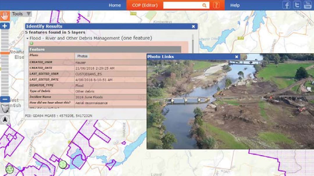
Using a data collection app, frontline personnel gathered important details from flood-affected areas and uploaded them for storage in a centralized database. This approach was crucial to ensuring that the initial rapid impact assessment was undertaken speedily and with precision.
Five apps deployed in five days
A suite of applications was developed so DPIPWE could complete a more detailed damage assessment, prioritize work, understand the financial impacts on businesses and critical infrastructure, and aid carcass and river debris removal. The data captured using these apps also enabled the department to gather critical evidence for NDRRA funding.
Real-time data feeds into the COP
Solutions were built to ensure that authoritative internal and external data—including static layers, such as aerial imagery, and dynamic data captured from helicopter and vehicle locations—was fed directly into the existing COP. This allowed the operations center and staff on the ground to have access to a continually updated picture of the disaster as it unfolded.
Results
Empowered to rapidly react and respond to floods
DPIPWE had the necessary tools to deliver immediate support, including during the rapid impact assessment—which was crucial in evaluating the extent of the damage and briefing decision-makers—and to assist emergency services organizations responding to day-to-day developments as the event progressed.
Secured state and commonwealth funding to assist affected communities
This sped up the recovery process for Tasmanians impacted by the flood, as they were able to quickly receive urgently needed financial assistance.
Increased effectiveness of the capture and compilation of detailed damage and impact assessment data
The rapid and successful deployment of GIS solutions undoubtedly increased the effectiveness of the recovery effort through the capture and compilation of location-referenced data across the social, built, economic, and environmental areas.
Increased confidence in GIS for state emergency response
The emergence of GIS as a mission-critical technology was recognized by the state's emergency response organizations—providing strong justification for DPIPWE's software investment.
Potential to reduce the scale and impact of future disasters
With detailed records of impacts and the actions undertaken during the floods, stakeholders can now conduct forensic examinations of historical data to develop better-informed mitigation strategies in years to come.