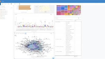
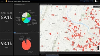
Data Analytics for the PSAP, Command and Control
Learn how PSAPs use ArcGIS Insights to fuse location analytics with open data science and business intelligence workflows.

Discover new insights, innovative best practices, and the latest advancements in GIS technology.

Stay up-to-date on public safety trends, technology, and best practices.
July 11-12, 2026, San Diego, California | Discover how GIS enables faster, better-informed safety and security decisions.
February 10-11, 2026, Washington, D.C. | Join your peers at the premier geospatial professional development event for government.
| Date | Event | Location |
|---|---|---|
| March 15–18, 2026 | CentralSquare Engage | Washington D.C. |
| April 15–17, 2026 | European Emergency Number Association Conference | Riga, Latvia |
| June 27–July 2, 2026 | National Emergency Number Association Conference | Columbus, Ohio |
| August 2–5, 2026 | Association of Public-Safety Communications Officials (APCO) Conference | San Antonio, Texas |
| Date | Event | Location |
|---|---|---|
| February 10–11, 2026 | Esri FedGIS | Washington, DC |
| March 8–9, 2026 | Esri Partner Conference | Palm Springs, California |
| July 11–12, 2026 | Esri Safety and Security Summit | San Diego, California |
| July 13–187 2026 | Esri User Conference | San Diego, California |
Data Analytics for the PSAP, Command and Control

Creating NextGen 3D Readiness in the PSAP
COVID-19 Data and Resources for the PSAP

Emergency communications webinar playlist