user story
Publishing Vehicle Accident Data to ArcGIS Online for Public Awareness
By James Miller, Business Development Manager (Public Safety), Esri Global
The Fukushima Prefectural Police case study has been sourced from the original Japanese version which was created and published by Esri Japan.
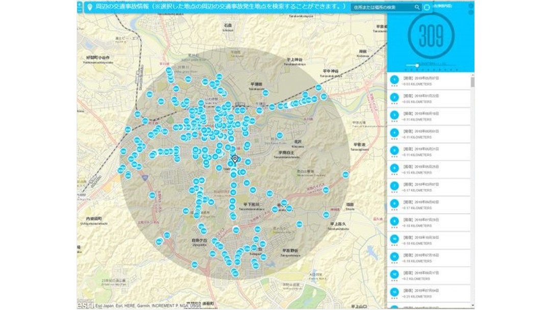
 Vehicle Accident Map for Searching within a Selected Vicinity
Quickly Publishing Traffic Safety Data
Fukushima is the third-largest prefecture in Japan and is divided into three regions: Hamadori, Nakadori, and Aizu. Each region has a unique climate and different road conditions, with different potential causes of vehicle accidents. Additionally, major highways that run through Fukushima are undergoing maintenance, resulting in a change for the traffic situation within Fukushima prefecture for residents, tourists, and commodity distribution.
In an effort to reduce the number of vehicle accidents, Fukushima Prefectural Traffic Police has been collecting and analyzing traffic safety data. As of December 2016, ArcGIS Online, Esri's software-as-a-service (SaaS) offering, was used to publish incident data to a public-facing web map.
Challenge
Fukushima Police officers manage traffic safety incidents within the prefecture through the system by collecting information at the scene of an accident, such as injuries, location, and demographics, and analyzing all these variables to better understand the patterns and common elements among vehicle accidents. The analysis is utilized for patrol and safety education activities to reduce the number of vehicle accidents. Each police precinct is responsible for leading roadway safety training by partnering with the local neighborhood and schools to examine the regions' traffic safety information and creating maps showing where incidents had occurred or had nearly occurred.
One challenge was increasing community-wide awareness of the public map. To help reach a larger audience, in 2015 the Fukushima Police started to investigate new ways to publish vehicle accident data. In addition, it added the requirement that the map must be viewable on mobile devices to reach young parents and others who typically use smartphones and tablets.
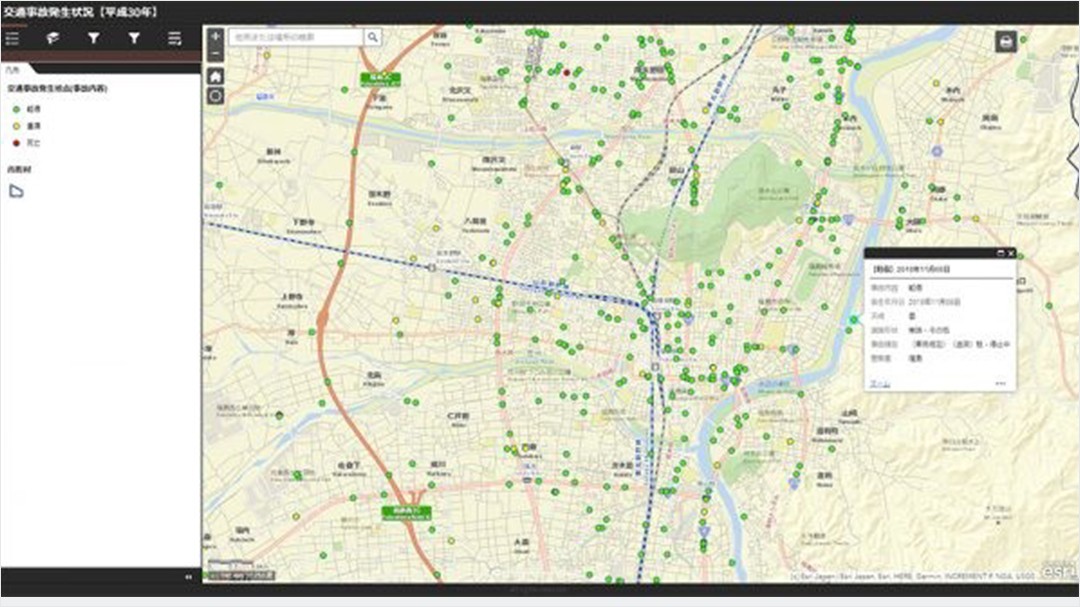
 Vehicle Accident Occurrence Map
Public Safety - Traffic safety analysis
User
Fukushima Prefectural Police
Challenge
Police needed to raise awareness of traffic safety and reduce the number of vehicle accidents within the Fukushima Prefecture.
Solution
ArcGIS Desktop was used to manage and analyze the accident data, which was then published in ArcGIS Online to web applications that could be viewed by the public through Esri Geospatial Cloud.
Result
Fukushima Prefectural Police was able to publish vehicle accident data much faster and effectively share information with other precincts, which also resulted in reduced overall operating costs.
Why the Police Adopted ArcGIS
Fukushima Police had previously used static maps to show high-risk sections of roadway and knew this would be an effective tool for communicating accident data with the public. Staff looked at other prefectures but did not find any that were using maps to communicate vehicle accident information to the public, and they needed a low-cost solution that required minimal effort. They determined that ArcGIS Pro, a professional desktop geographic information system (GIS) application, could be used to manage and analyze data, complemented by ArcGIS Online to publish this information to web applications viewable by the public.
Solution
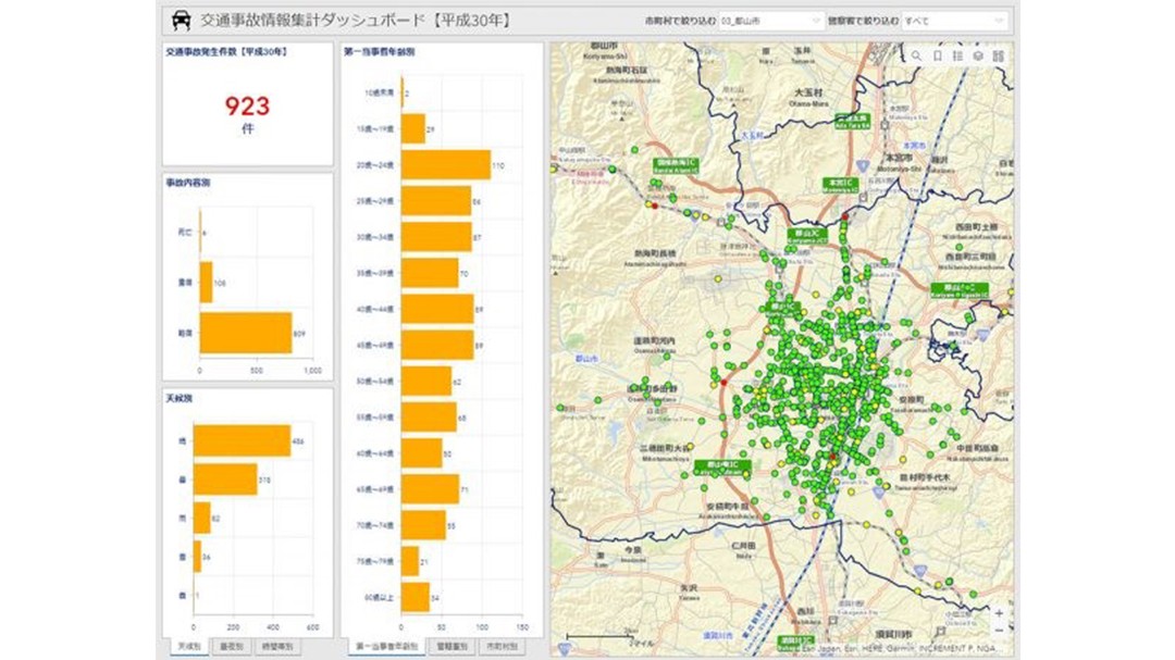
The vehicle accident data includes personally identifiable information about those involved, but Fukushima Police needed to publish the vehicle accident data without compromising victims' private information. As a result, the decision was made to publish the date and time of the incident, the primary victim's age group, weather conditions, the location and shape of the road, the severity of the accident, and the type of accident. Staff started by importing the vehicle accident data into ArcGIS Pro for analysis. ArcGIS Online was then used to publish the results to a web application called "Public Vehicle Accident Information System". The system provided a map that was both visually appealing and easy to use. This was achieved by showing the accident locations and color-coding the points by accident type while highlighting major accident locations. Staff also utilized Operations Dashboard for ArcGIS to show graphs for the number of vehicle accidents by city/precinct, weather, age group, and the year the accident occurred.
As of 2020, the public can see the following five types of maps for each year:
- Vehicle accident map
- Vehicle accident map by month
- Vehicle accident map searchable by selected vicinity
- Vehicle accident information summary dashboard
- Vehicle accident map (for smartphone viewers)
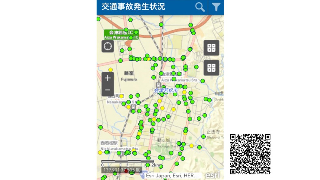
It was simple to configure smartphone-compatible mobile apps by using out-of-the-box ArcGIS Online mobile app templates. The Public Vehicle Accident Information System can be accessed from Fukushima Police's website.
 Vehicle Accidents (for smartphones) and the QR Code to access the Public Vehicle Accident Information System
Results
By using ArcGIS Online, the Fukushima Police did not have to develop a system from scratch, thus saving time and cost.
Using ArcGIS Online enabled Fukushima Police to shorten the time it took to publish vehicle accident information. Previously, officers would have to manually input the vehicle accident data and provide that information to each police precinct, which was a very time-consuming and labor-intensive process. With the Public Vehicle Accident Information System, the Fukushima Police officers could update the data themselves, which resulted in reduced time between an accident's occurrence and the publishing of information.
The system also enables neighboring police precincts to easily share information with one another.
The Public Vehicle Accident Information System had also successfully captured the interest of the public after Yomiuri Shimbun, a major newspaper in Japan, published the article "Fukushima Police Publishes a Vehicle Accident Data Map on Their Website for the First Time in Northeast Japan" on March 15, 2017.
 Vehicle Accident Information Summary Dashboard - Summary by City
Future Vision
To reduce the number of vehicle accidents, the Fukushima Police is considering a public relations campaign to bring more awareness to the Public Vehicle Accident Information System. In the future, it would like visiting tourists to be aware of locations and conditions that frequently lead to vehicle accidents, helping ensure safe travel in Fukushima.
As vehicle accidents are deemed to be the most dangerous common threat to the safety and well-being of Fukushima residents, the Fukushima Police will continue its efforts to reduce the number of vehicle accidents by raising awareness of risk factors through the Public Vehicle Accident Information system.