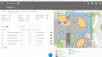
Facilities GIS for Tribal Communities
Staff from Esri and PenBay explain how GIS can save a tribe's money, protect people and assets, and create safe and productive environments.


| Date | Event | Location |
|---|---|---|
| July 15–19, 2024 | Esri User Conference | San Diego, California |
| Date | Event | Location |
|---|---|---|
| TBD | Environmental Protection Agency (EPA) Tribal Exchange Network | TBD |
| TBD | Bureau of Indian Affairs (BIA) Provider Conference | TBD |
| April 2, 2024 | National Tribal Land Staff Conference | Las Vegas, NV |
| TBD | National Tribal & Indigenous Climate Conference | TBD |
| April 8, 2024 | Indian Gaming Tradeshow & Convention | Anaheim, CA |
| April 29, 2024 | National Tribal GIS Conference | Albuquerque, NM |
| May 19, 2024 | NIHB 2023 National Tribal Health Conference | Rapid City, SD |
| May 19, 2024 | Inter-Tribal Council Nevada | TBD, Nevada |
| September 16, 2024 | TribalNet | Las Vegas, NV |
| TBD | National Transportation in Indian Country Conference | TBD |
| December 2, 2024 | BIA Provider Conference | Anchorage, AK |
Date: February 21, 2024
Time: 11:00 a.m. (PT)
Location: Virtual
Cost: No cost
Language: English
Join us for an insightful webinar as we dive into the unique challenges of addressing tribal communities. In many tribal regions, the absence of formal address data has posed significant hurdles to getting things done, from coordinating emergency responses to accessing essential services. Discover how ArcGIS tools can assist with establishing comprehensive address inventories, facilitating next-gen/enhanced 911 systems, and driving economic development initiatives to ensure community sustainability.
We've invited our partners from Tukuh Technologies to copresent and bring additional expertise and insights to the discussion. Uncover how ArcGIS is not just mapping addresses but also creating pathways to empowerment and inclusivity for tribal communities nationwide. Take advantage of this opportunity to witness the tangible impact of GIS technology.
On Demand
Time: On demand
Location: Virtual
Cost: No cost
Language: English
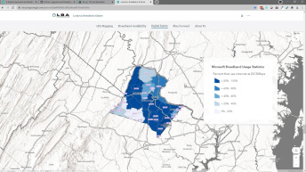
A digital twin is a virtual representation of current conditions in a community—economic status, roads, electrical outages, and broadband availability—modeled from systems of record, data from real-time sensors, and behaviors.
Learn how tribal governments can design and use a digital twin to
On Demand
Time: On demand
Location: Virtual
Cost: No cost
Language: English
A geospatial strategy is a business-oriented plan designed to help change the functions and behavior of an organization to deliver added value. This strategy defines how your organization will use GIS to achieve specific goals and desired outcomes. This plan includes how to leverage people, processes, and the technology needed to meet your defined goals and outcomes.
On Demand
Time: On demand
Location: Virtual
Cost: No cost
Language: English
Aligning your GIS work and initiatives with the vision your leadership has for your organization is critical. To establish or expand support for your GIS work, you need to secure your leadership's sponsorship through effective communication. Therefore, it is vital that you learn how to communicate the value of your program or project as a solution to a problem the executive is interested in solving. To do this, it is best to frame your program or project in one of two ways—either in relation to the leader's vision or the leader's challenge.
On Demand
Time: On demand
Location: Virtual
Cost: No cost
Language: English
GIS leaders are usually not associated with specific job descriptions, positions, or titles. They can be managers, analysts, technicians, administrators, developers, programmers, or specialists. They lead by example and serve as partners and advisers who refine and enhance GIS business processes. If you lead a GIS team—or aspire to—join us for this session; it will benefit current and future GIS managers, business and technology strategists, and decision-makers.
Facilities GIS for Tribal Communities
ArcGIS Hub for Tribal Government
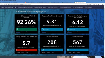
GIS for Tribal Government
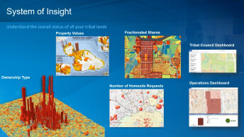
Modernizing Land Management Workflows
Bridging the Digital Divide on Tribal Land
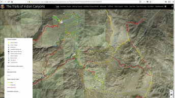
Apps to Support Your Tribe's Needs