
Clarissa Paz
Solution Engineer, Esri

Solution Engineer, Esri

Solution Engineer, Esri

Solution Engineer, Esri

Solution Engineer, Esri
ArcGIS Online is a cloud-based software as a service (SaaS) mapping and analysis solution. The new Map Viewer—the next generation map-making tool in ArcGIS Online and ArcGIS Enterprise—released spatial analysis tools in June 2023. In this Lunch & Learn, we will highlight key features of Map Viewer, analyze data in the cloud, and use the power of SaaS to distribute our analyses to constituents and key stakeholders.
January 25, 2024

Already a Microsoft 365 user? Add ArcGIS for Microsoft 365 to your toolkit! In this Lunch & Learn, we’ll demonstrate how to gain valuable insights and enhance collaboration by leveraging ArcGIS for Excel and ArcGIS for Power BI to go beyond spreadsheets, charts, and graphs by creating, sharing, and automating business workflows using Microsoft applications.
February 29, 2024

Imagery and remote sensing data are foundational sources of information for most geospatial workflows. In this Lunch & Learn, we will explore ArcGIS Image as a SaaS product using ArcGIS Online to host, analyze, and visualize your imagery in 2D and 3D. We will also examine the use of GeoAI functionality within the ArcGIS Image for ArcGIS Online environment.
March 28, 2024
In this Lunch & Learn session, we will review the expansive geoprocessing capabilities of ArcGIS Pro, now at full parity with ArcMap. We will also review new analytical capabilities and guide the audience through multifaceted workflows within ArcGIS Pro.
April 25, 2024
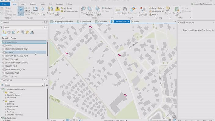
In this Lunch & Learn, you will learn how ModelBuilder allows you to create geoprocessing models that document and create automated GIS workflows by adding data and tools and connecting them or creating workflows from an existing project history. You will also learn about model elements, types of tools, connections, environments, and best practices to organize and document the model.
May 30, 2024
In this Lunch & Learn, with examples in public health and access to care as well as other industries, we will assess network adequacy and evaluate and optimize the distribution of goods and services using ArcGIS Network Analyst in ArcGIS Pro, ready-to-use network analysis services, and GeoEnrichment capabilities across ArcGIS.
June 27, 2024

Learn from Esri solution engineers as they share highlights from this year's Esri User Conference (Esri UC).
August 22, 2024
In this Lunch & Learn, discover how to use ArcGIS Velocity—a real-time and big data analytic —to connect to streaming data, perform real-time analytics and processing, automatically disseminate information, and alert personnel when specified conditions occur. We will also share possible uses, such as on-site personnel safety or snow/winter event preparation.
September 2024
In this Lunch & Learn, discover how you can use ArcGIS for public engagement: Decide which apps are best for connecting to your constituents, whether that's using ArcGIS Hub—Esri's cloud-based engagement platform—or utilizing ArcGIS Instant Apps, a quick and intuitive way to transform your maps into interactive web apps for your users.
October 24, 2024

In this Lunch & Learn, discover various methods for data visualization, creation of infographics, and steps to generate analysis reports using ArcGIS Business Analyst and ArcGIS Community Analyst. These powerful tools offer a wide range of capabilities for market planning, site selection, and customer segmentation—allowing you to make informed decisions.
November 21, 2024