Iraq has had a rough ride in recent times, and many of its cities are showing the scars of years of neglect and warfare. A lack of investment in basic infrastructure, combined with a brain drain of professionals, has left many Iraqi cities in a very poor state of repair and with limited plans for the future. But with the fall of the previous regime have come opportunities to revive and repair these aging and often historic cities.
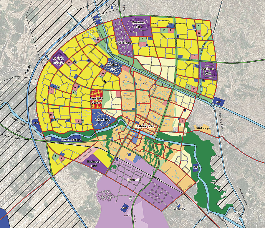
In 2007, the Iraqi Ministry of Municipalities and Public Works (MMPW) awarded a British firm, Garsdale Design Limited (GDL), and its Iraqi Planners Group (IPG) the contract to develop a master plan for the city of Nasiriyah in southern Iraq. The project was to deliver urban planning for the new dwellings, infrastructure, sewerage, water, and electric systems needed over the next 30 years. Nasiriyah is the capital of Dhi Qar province in Iraq. Almost 500,000 people call this city their home, located 225 miles southeast of Baghdad on the Euphrates River and close to the ancient city of Ur.
Garsdale Design is a planning, architecture, and heritage consultancy based in Cumbria in the United Kingdom. It has extensive experience in the Middle East, and many of its projects have entailed urban design and city master planning in the Gulf Arab states.
“Master planning any city is a complex task,” says Elliot Hartley, director of Garsdale Design, “but Iraq’s cities face huge additional challenges from lack of investment in infrastructure to training of planning departments.” Hartley manages and analyzes the spatial data that is required for planning projects like the Nasiriyah City Master Plan.
Magical Modeling
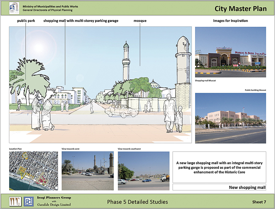
The staff at GDL focused on planning a contemporary community in Nasiriyah with an integrated public transport network that still reflects the culture and history of the almost 150-year-old city. The goal is to help the city grow sustainably over the next 30 years.
Over time, GDL had experience with various time-consuming spatial packages that did not meet its needs. Pursuing a better solution, GDL and IPG concluded that ArcGIS with Esri CityEngine met and exceeded the needs of MMPW. On production of some of the 3D modeling, GDL staff found that they were able to remodel iteratively in response to new data or late requests. This created results that Hartley describes as “almost magical.”
“When presented with this reality, we thought, what if the project team could change detailed plans with ease, taking into account new data instantly and avoiding the laborious redrawing of layouts?” says Hartley. “This is the promise of the ‘instant city’ and what we can achieve with GIS.”
Creating a Responsive Model
The GDL team quickly realized that CityEngine could be part of the master planning process and not just a visualization tool.
“Unfortunately, we can’t just jump into a new workflow in the middle of a project. This could have unacceptable impacts for us and our clients,” says Hartley. However, the company quickly learned that using CityEngine on elements of master planning projects helped to visualize where the pieces best fit.
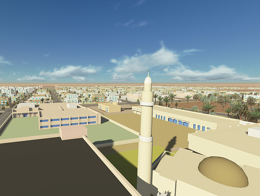
The first task performed with the 3D modeling software was building a new neighborhood with basic block models. Data from previous phases of the project was used to visualize elements of the master plan quickly in realistic 3D visualizations in just a matter of hours.
“This would have taken many hours, if not days, to produce in-house using other 3D modeling packages,” says Hartley.
Mining Its Stock of 3D Models
Over the years, GDL has built up a stock of 3D models used for previous jobs that provide inspiration for current work. Using CityEngine, these models were imported and their preexisting 3D assets and rule files put to use, with a few quick adaptations. For example, staff employed a rule file that tests the size of a plot and places an appropriately sized building model accordingly. A specific set of vegetation models that included native trees was also used, with one tweak—existing tree rules were replaced with a new definition. Streets were then modeled with these trees—palm trees—and the trees were randomly inserted on lots to give a more natural look to the model.
Employing Python scripting allowed staff members to go back and forth between the ArcGIS environment for conventional mapping and CityEngine for 3D modeling. For example, a street centerline was created in ArcGIS and then brought into CityEngine, where curbs, central medians, streetlamps, and trees were added in accordance with the rule file. The result was then exported back to ArcGIS for analysis and mapping. This data was then used to create plots and place building types according to the underlying land use in CityEngine, then brought back into ArcGIS for further analysis.
“This goes beyond standard visualization and into actual creation of data based on our specific urban planning standards,” says Hartley. “The ability to dynamically add attributes to plots with rules allows for a more responsive model.”
When the Future Means Change
Underlying data, such as relief or geology, can also be used. For example, a raster with a red color can be used to restrict development in particular areas, and elevations can be used to restrict building heights or types.
Staff used the modeling rules they need for each individual project, no matter how general or detailed, so different issues can be modeled at either micro or macro scales.
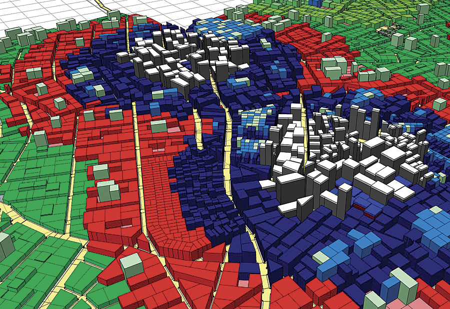
“Sometimes we have started with a relatively simple rule file for land uses,” says Hartley, “but have then combined it with a previous dwelling rule file that links to yet another one to locate small elements, such as water tanks and satellite dishes.”
Intelligent modeling in this manner is starting to generate questions, such as the following, and quickly provide answers:
- What size of plot is needed within a particular land block?
- Can building height be varied to recognize the underlying geology?
- How can lots smaller than a certain size be shown as playgrounds within a residential area?
- What lane and sidewalk width is required for the different grades of roads?
- How wide should the central median be for higher-order roads?
- Can streetlamps be modeled differently to suit the various grades of road?
- Can buildings be modeled at different heights depending on how close they are to a center or transport node?
“In the future, we are going to be able to create a city plan that changes very quickly as new data arrives from the client,” says Hartley. “This is a game changer for firms like ours, as last-minute client requests at a late stage are inevitable.”
A Living Model
When Garsdale Design staff started working with CityEngine, the primary appeal was the software’s ability to work with GIS data and export it into a variety of 3D modeling and rendering packages to provide the materials required by the client. “But once we started to explore the potential of the software, we saw that it could be more useful as an urban planning tool,” says Hartley. “In fact, it has also shown us an exciting new direction for planning cities in the future. We can start to use these sophisticated 3D visualizations in a variety of media, including printed reports, websites, video, and full interactive walk-throughs. Our clients want to see how their cities would look when their plans are implemented.”
For more information, contact Elliot Hartley, director of Garsdale Design Limited.

