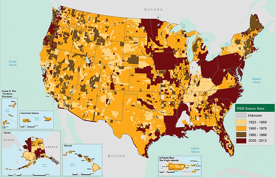
As the lead federal agency for terrestrial elevation data, the US Geological Survey (USGS) has managed the National Elevation Dataset (NED) and coordinated its activities through the National Digital Elevation Program (NDEP) for more than 15 years. The NED, managed as part of The National Map, has represented the standard of quality for elevation data in the United States during this time. Today, new elevation data is acquired using modern technologies to replace elevation data that is on average more than 30 years old. Through the coordinated efforts of the NDEP, a project-by-project data acquisition approach has resulted in improved, publicly available data for 26 percent of the conterminous United States and 37 percent of Alaska over the past 13 years.

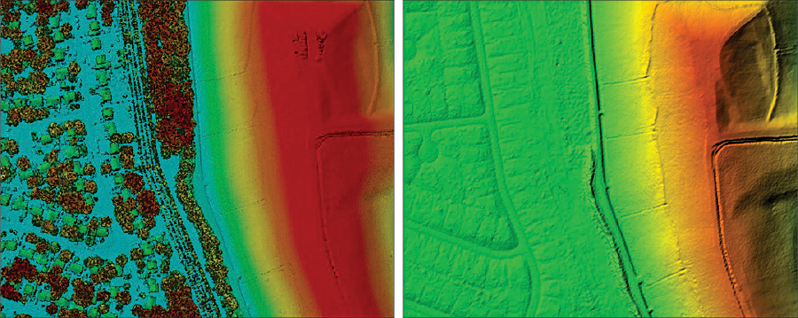
The 3D Elevation Program (3DEP) is a call for action to accelerate the collection of high-quality light detection and ranging (lidar) data in the conterminous United States, Hawaii, and the US territories and interferometric synthetic aperture radar (ifsar) data in Alaska. Lidar and ifsar data will be available for the nation, and the NED will be completely refreshed with new elevation data products and services. The initiative is being led by USGS and includes federal agencies, states, and tribal partners, who will work together to build on existing programs to complete national 3D elevation data coverage in eight years. The 3DEP initiative is far reaching and strives to address national requirements through a partnership framework. The governance structure includes an executive oversight committee and a multiagency coordinating committee built on the committee structure already in place under NDEP. As proposed, a 3DEP effort would be supported at a total cost of $146 million annually. If fully funded, it is estimated that 3DEP could return more than $690 million annually in new benefits to the private sector directly and to citizens through improved government program services (see the National Enhanced Elevation Assessment [NEEA] report). Current investments in publicly available lidar and ifsar data are approximately $50 million annually.
The 3DEP initiative is based on the results of the NEEA that was funded by NDEP agencies and completed in 2012. The study, led by USGS, identified more than 600 requirements for 3D elevation data to address the mission-critical requirements of 34 federal agencies; all 50 states; and a sample of private sector companies, tribes, and local governments. Many requirements were identified where high-quality 3D elevation products would never be affordable if the data was acquired to solely meet a specific need. For example, the wind power industry requires volumes of very high-quality surface data over large areas to plan wind farms and to determine ideal placement of wind turbines. It would be costly for this industry to fund the acquisition of high-quality lidar data to solely support that purpose. Yet when all the overlapping needs from multiple users are considered, a national program is more than justified. The NEEA study identified many applications that are similar to the wind energy example. In contrast, funding for data collection today comes from government agencies where mission-specific needs are driving data acquisitions. While this data collection strategy has benefited individual projects and government programs, it cannot comprehensively address the needs or achieve the benefits as documented in the NEEA report.

In a resource-constrained environment, we cannot just rely on increased funding to advance the goals of 3DEP. Improved program efficiencies and advancements in technology to increase data collection rates will also be necessary. The 3DEP initiative will achieve a 25 percent efficiency gain by moving toward larger projects where data collection costs are inherently lower. To achieve this goal in eight years, however, investments and production rates will need to increase threefold. In order to create the level of participation from cooperating agencies and to ensure that mission needs can be addressed, the initiative proposes to
- Increase overall investments through budget and other initiatives in order to provide greater incentive for increased partner engagement.
- Ensure that the mission needs of partner agencies and states are addressed by incorporating their requirements into a three-year joint planning strategy.
- Encourage federal, state, and tribal government participation through advantageous partnerships that adhere to accepted quality standards while recognizing the need for flexibility among partners.
- Achieve efficiencies and lower costs through larger area acquisition projects.
- Manage 3D elevation data and make it freely available for everyone.
USGS has been designated by the Office of Management and Budget (OMB) as the lead federal agency for terrestrial elevation data (OMB Circular A-16). The 3DEP initiative is designed to fulfill that coordination responsibility and to ensure that the needs of the nation for high-quality lidar and ifsar data are being met. This role cannot be met by USGS alone, and the 3DEP initiative should not be considered to be solely a USGS activity. Partnerships with federal agencies, states, and tribes are a cornerstone of the planning and initiative development process. USGS and the National Oceanic and Atmospheric Administration work together to conduct annual inventories of available lidar and ifsar data.
About the Author
Larry Sugarbaker is the National Geospatial Program senior adviser for the US Geological Survey, where he works on National Map policy-related issues and new program initiatives. He has been vice president and chief information officer for NatureServe and GIS manager for the Washington State Department of Natural Resources.
To find out where lidar and ifsar data is available, go to www.csc.noaa.gov/inventory. To download the most current digital elevation model data available from USGS, go to viewer.nationalmap.gov/viewer. To get involved, more information about 3DEP can be found at nationalmap.gov/3DEP.
Related Podcast
GIS and Lidar Converge in USGS 3D Elevation
Larry Sugarbaker, senior advisor for the National Geospatial Program for the United States Geological Survey (USGS), discusses the advances in lidar and geospatial technology that gave rise to the 3D Elevation program. Listen to the podcast. [23:00 | 22 MB]
