
GIS Hero
He has dedicated his life’s work to indigenous peoples and their land rights. He counts conservation among his passions as well—though, at times, the two have come into sobering conflict. With GIS, however, he has ironed out some of those wrinkles and produced extraordinarily innovative work on indigenous communities’ landholdings and histories.

Richard Chase Smith is an American who has made his home in Peru for most of the last five decades. As executive director of the Instituto del Bien Común (the Institute of the Commons, or IBC), he advocates protecting and preserving what is common to human existence—water, air, land, forests, fisheries—even culture. He believes that, in many cases, indigenous peoples are the natural stewards of these vital resources and customs.
“The whole story begins with indigenous peoples,” he said. This is true both around the globe and on a personal level for Smith.
In 1966, as a fresh graduate of Dartmouth College with a degree in geography, government, and economics and a curiosity about land reform in Latin America, Smith joined the fairly nascent Peace Corps in Peru.
“I ended up on the eastern side of the Andes in a small, originally German settlement, working in a land reform office in that town,” he recalled. “One of the cases that I got involved in almost immediately was a big conflict between a community of indigenous peoples…and the Catholic Church.”
The case involved the Yanesha people, speakers of the Arawak language. They were living in forested areas of the eastern Andes mountains, where a Catholic mission had also been for more than 100 years. The Catholic Church was fighting this small community of original peoples for control of the land.
Smith traveled throughout this upper Amazonian region to visit other Yanesha settlements. He soon found out that every group was having land issues. And the Peruvian government, which deemed the Yanesha people chunchos, or wild peoples, was uninterested in their situation.
Smith recorded data (such as population statistics and land conflicts) about the Yanesha people and hand drew maps of their settlements. He got land reformers to start paying attention to these original peoples.
After talking to a number of younger and elderly Yanesha people, Smith realized that the different groups needed to unite around their shared cause. He visited 24 far-reaching settlements and convinced the groups to meet on July 1, 1969, to talk about the situation and ways to confront land tenure insecurity.
It was an amazing success. People walked for days to get there, and the more than 100 participants agreed to establish an intercommunity organization and make the president of Peru aware of their peril. They did both, and that marked the beginning of land rights work for Amazonian peoples in Peru.
To see if he could be of more help, Smith enrolled in a PhD program in anthropology at Cornell University under the tutelage of John Murra, one of the pioneers of Andean anthropology. After completing his coursework, Smith returned to Peru to do his thesis with the Yanesha people—specifically, on their oral history, social relations, and how they use music to understand cosmovisión (how Mesoamerican peoples perceive and interact with time and space). He also continued to work on land issues, helping to get a law passed that recognized indigenous peoples’ land rights.
During this time, Smith discovered the Yanesha peoples’ remarkable vision of their landscapes.
“They have this incredible system of epic narratives, each narrative having 10, 20, 30, 50, 100 chapters—all depending on memory and passed on orally,” Smith said.
But it was not myth—something that many people believe to be untrue—that was being conveyed.
“This was actually history that they were talking about—past leaders who had gained incredible importance in their lives, incredible powers,” he continued. “I began realizing that these epic narratives were all related to landscape, and that these place-names were markers of where certain things in this oral history took place.”
Smith began collecting information on this rich knowledge. But he was frustrated that there was no good way to store the information and display it on maps.
After finishing his thesis, Smith returned to the United States for postdoc work at Harvard University. He then took a position at Oxfam America in Boston, where he and some other program officers set up an on-site program in South America that focused on indigenous peoples.
In 1988, Smith moved to Lima, Peru, to lead the program. That same year, he went to an exposition of maps put on by the United States Agency for International Development (USAID) and the Peruvian government where they showcased, for the first time, GIS.
“It was an epiphany for me,” he said. “That was my dream!”
GIS was exactly what Smith had been looking for: a repository for the Yanesha people’s place-names, landscapes, and oral histories. A project that he continues to work on today, it is beginning to revolutionize how the world views the role of Amazonian cultures in ancient civilization.
GIS would help his land rights work as well.
Five years later, Smith presented a paper at the Esri User Conference on the possible uses of GIS for indigenous peoples. Charles Convis, now the Esri Conservation Program coordinator, noticed how insightful Smith was about the importance of indigenous communities in any conservation endeavor.
“It’s the folks at the very local level who most truly understand what’s going on and what needs to happen,” reflected Convis.
Contrary to what many people think, indigenous peoples are not the adversaries of conservation. They understand how nature works in ways that others don’t.
The same goes for Smith and his knowledge of how indigenous peoples care deeply for and conserve their land.
“He speaks from a depth of experience that’s not common,” said Convis.
Smith was given a complimentary copy of ARC/INFO, which he took back to his research groups at Oxfam so that they could learn to use it immediately.
Shortly thereafter, the group did a pilot study using GIS and GPS to map the lands of the Witoto and Bora peoples around the Ampiyacu River in the Peruvian Amazon. This gave rise to the Native Communities Information System (SICNA), a project that, by the end of 2016, will have mapped more than 2,000 native communities in the Peruvian Amazon.
By the year 2000, Smith and his newly founded organization, IBC, were producing novel maps of Peru that displayed government-recognized indigenous lands.
“We could begin showing the conflicts between indigenous lands and mining concessions or petroleum concessions or even conservation areas established on top of them,” he said. “That was kind of a revolutionary moment here in Peru, when people could begin to visualize those kinds of conflicted relationships.”
Just a few years later, Smith and some of his land rights colleagues in the region started the Red Amazónica de Información Socioambiental Georreferenciada, or RAISG, to create Pan-Amazonian maps of indigenous peoples and protected areas. And RAISG is still going strong.
“It’s not easy to get mapping groups to come together, partly because people are so protective of their information,” Smith said. “As far as I know, we are the only regional mapping group in the world that’s stuck together.”
The deliberations that were required to get RAISG off the ground paid off tremendously, as RAISG is now a model for an even more ambitious project.
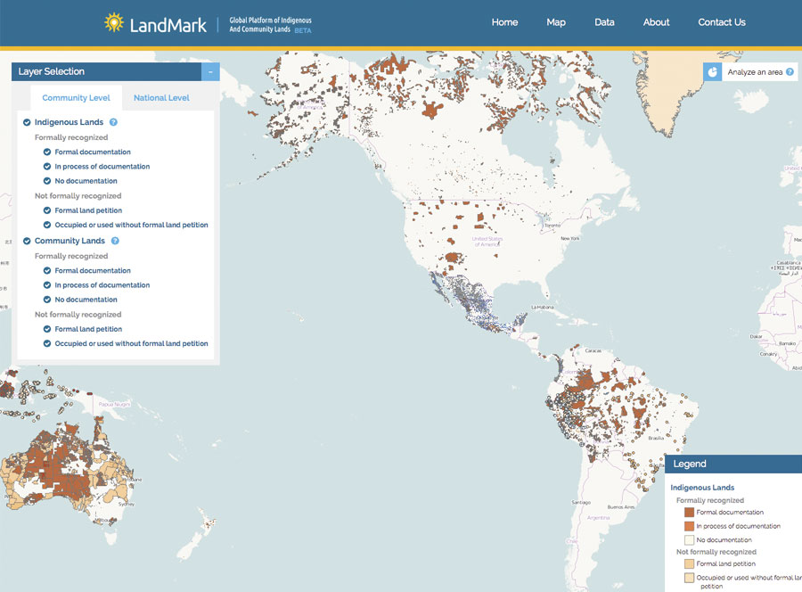
In 2013, at a meeting of select thought leaders on land tenure security for communities and indigenous peoples around the world, Smith volunteered with Peter Veit of the World Resources Institute to head a work group on documenting and mapping community lands. The two of them wanted to build a global platform that allowed people to visualize community and indigenous landholdings all over the world.
In subsequent meetings, the idea stuck. And after two years of vigorous work with a number of international partners to gather information on indigenous and nomadic land claims and uses, the group launched LandMark in November 2015.
The interactive map shows data at two different levels. First, there are detailed shapefiles of indigenous and community lands. Second, there is country-level data, which shows the percentage of each nation’s landmass that is under some kind of community or indigenous control, as well as an index that details each country’s laws about land rights for indigenous peoples and/or communities.
“It’s a work in progress, and it’s going to be a work in progress for years to come,” acknowledged Smith.
But, little by little, Smith and his colleagues are getting organizations and government entities to share their data on indigenous and community lands. This puts pressure on world governments and international institutions to respect those lands and the resources of original peoples.
“We push for recognition of communal landholdings not so much to preserve the past but to give security for a future,” said Smith. “All of our future.”
Read other articles in the “GIS Heroes” series.