In the March 2014 update, we added new features and capabilities that improve the user experience and make it easier to manage your ArcGIS Online subscription.

ArcGIS Online Account Administration
Many organizations need the ability to create unique roles for their ArcGIS Online members. The new custom role capability gives administrators greater control and flexibility in assigning privileges to individual members. For example, some members only need access to maps and apps but don’t need to create groups. Others might need to publish features but not tiles. Now you have the ability to tailor roles so that they fit your organization’s workflows and needs.
A new Activity Dashboard for ArcGIS is available in ArcGIS Marketplace. This free web app gives administrators access to activity-based metrics, real-time reports, and other useful information in addition to the reports already available to ArcGIS Online administrators.
Analysis
With the Derive New Locations tool, you can create new features in your study area that meet a series of criteria you specify. The criteria can be based on attribute queries, for example, parcels that are vacant, or spatial queries, for example, parcels that are within one mile of a river. The new Find Similar Locations tool finds the locations that are most similar to one or more reference locations based on criteria you specify.
Overlay Layers now has an option for specifying the output feature type when using the Intersect method. When you click Perform Analysis, there is a submenu that allows you to select which feature type to analyze for Map Notes, KML, or any group layers that contain features.
More than 30 new countries have been added to the Enrich Layers tool. And you now can analyze KML layers.
Map Viewer
We’ve improved how you can resolve unmatched geocoded addresses. After you publish a hosted feature layer from a CSV file, you can use the map viewer to review the addresses in the layer. You can map all suggestions for unmatched addresses or edit attribute fields in a table to rematch individual addresses.
There are three new collections of symbols and map note templates for showing the location of natural disasters, infrastructure, and infrastructure damage. A new route to all features option lets you get directions for feature layers with 20 points or fewer.
App Templates
Find, Edit, and Filter is a new configurable app template that allows you to search for features, edit, set attribute values, and filter content.
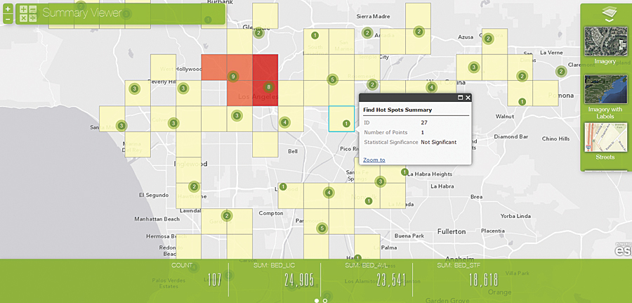
Summary Viewer is a new configurable app template that summarizes the numeric attributes of features in a specified operational layer that are within the visible map area. The summaries can be configured to show the sum, average, minimum, and maximum of specified field values.
Parcel Viewer has been renamed Finder to reflect that it is useful for more than just parcel searches.
Ready-to-Use Apps
Collector for ArcGIS—You can now view maps offline and collect and edit features when you are disconnected from the Internet. Manage your map content on your smartphone or tablet device and synchronize changes when you are reconnected.
Operations Dashboard for ArcGIS—This app is now supported on iOS and Android tablets. By accessing your operations views through your device’s browser, you can have the same real-time view on your tablet that you see on your desktop computer. You can use dynamic map layers as a data source and search for features by coordinates as well as places. There are also new capabilities for creating and managing selections and adjusting matched records.
Explorer for ArcGIS—Released in late April on the iOS platform, this new app allows you to discover, visualize, use, and share maps within your organization. You can view information about your assets and redline or mark up your maps, making it easy to collaborate with others.
Open Data—With this new capability, currently in beta, organizations are able to provide open data access to the public. Anyone can search by topic or location, download data in multiple formats, and view data on an interactive map and in a table. During the beta period, organizations who have a paid ArcGIS organizational subscription can create an open data site and make select data publicly available. Organizations that have an ArcGIS Online trial account can also create an open data site to evaluate and understand how the process works but will not be able to make their data publicly available as part of their trial. ArcGIS Online for Public Use subscribers and those who have an ArcGIS for Developers account can search and access open data sites. The final release of the open data capability is planned for the ArcGIS Online July update.

Other Enhancements
Single Sign-on to the ArcGIS Platform—You can now sign in to the ArcGIS platform and seamlessly access web apps registered with the platform. These web apps include apps you’ve purchased from ArcGIS Marketplace, custom web apps built by developers in your organization, and apps built by Esri that are included with your organizational subscription. Once you are signed in to the platform, you only need to approve that the app you are working with can access your account information.
World Geocode Service—This service has been enhanced for 10 countries, including Puerto Rico, Singapore, and Suriname.
Network Analysis Directions—Estonian and Latvian have been added to the 17 other supported languages. There is also a new Find Routes service available in ArcGIS for Desktop Ready-to-Use Services.
Elevation Analysis Services—The Watershed and Trace Downstream services for hydrology analysis are now available globally.
ArcGIS Online Content Updates
Tile Resampling—Previously, basemap areas that lacked content at large scales displayed a gray box with the message “Map data not yet available.” In early March, we introduced tile resampling where browsers resample the last cache level. This enables the map to display data uniformly down to the largest scale level of a particular ArcGIS Online basemap being viewed.
GeoEnrichment—Thirty new countries have been added, making the service available for more than 100 countries. There is also updated content for Canada and the United States.
Dark Canvas Basemap—This basemap, currently in beta, has been updated with content at larger scales (~1:9 k) for these four areas: Chicago, Illinois, USA; Perth, Australia; Geneva, Switzerland; and Milan, Italy.
Ocean Basemap—This basemap has been updated so that labels and features are now in separate layers, enabling users to turn off labels or display their data underneath the labels.
Imagery—A new set of Moderate-Resolution Imaging Spectroradiometer (MODIS) imagery layer maps and layers is available, referencing a collection of National Aeronautics and Space Administration (NASA) imagery. The MODIS imagery provides 250-meter, multispectral satellite imagery of the world that is updated daily. It has a near real-time (three-hour delay), deep, and fine-grained temporal archive that helps provide global and fine temporal context for making decisions and visual assessments of conditions for any day and anywhere in the world. This is a mashup of a NASA image service. The value is mostly in providing global and fine temporal context; adding in decision making; or as a quick visual assessment of conditions any day, anywhere. The World Imagery basemap has been updated with nearly 2 TB of high-resolution imagery from DigitalGlobe. This is the first of two updates planned for this year. Areas that were updated include 30 cm imagery in the United Kingdom and Western Europe and 50 or 60 cm imagery in parts of Canada; Mexico; South America; Eastern Europe; Russia; India; Africa; Southeast Asia; and Pacific regions, including Australia and New Zealand. Contributions through the Community Maps Program include imagery for Denmark provided by Geodatastyrelsen (Danish Geodata Agency) and Informi GIS. Contributions were all received for Hamburg, Germany (30 cm imagery); Dawson Creek, British Columbia (25 cm imagery), Camrose, Alberta, Canada (15 cm imagery); and several other Canadian communities.
World Topographic Map—New and updated content received through the Community Maps Program was added to the World Topographic Map for Bermuda and Japan (~1:577 k); the Netherlands (~1:9 k to ~1:1 k); Suriname (~1:288 k to ~1:1 k); Albertov University and Masaryk University, Czech Republic; Warsaw University of Life Sciences, Poland; Galati and Oradea, Romania; several areas in the Northwest Territories, as well as a number of communities in Canada; and numerous communities in the United States, including Hermosa Beach, California; Lakewood, Colorado; Madison County, Idaho; Lake County, Illinois; Des Moines, Iowa; Anderson, South Carolina; Fairfax County, Virginia; Montclair State University, New Jersey; and Idaho State University, Idaho, all at ~1:9 k to ~1:1 k.
All core basemaps (World Street, World Topographic, Canvas, and Reference Overlays) have been updated with content for Africa at ~1:288 k to ~1:4 k continent-wide and to ~1:1 k in select urban areas. For a complete list of all contributions to each of the world maps, visit esri.com/contributors.
