
ArcGIS Already Supports GeoPackage
“Esri continues to add support for many open and interoperable data sources,” says Keith Ryden, Esri software development team member, who led Esri’s work on GeoPackage and worked on the Open Geospatial Consortium, Inc. (OGC), standard. “Adding GeoPackage support was a natural progression to our previous support of OGC WMS, WMTS, WFS, WCS, and OGC KML. We are committed to making our users successful, and we had users interested in Esri’s early support of GeoPackage, so we ended up supporting even the draft specification prior to its becoming an OGC standard,” continues Ryden. “We will be interested to see how popular the use of GeoPackage becomes.”
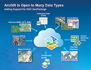
The OGC Encoding Standard defines GeoPackage for exchange and GeoPackage SQLite Extensions for direct use of vector geospatial features and/or tile matrix sets of earth images and raster maps at various scales. Direct use means the ability to access and update data in a native storage format without intermediate format translations. This guarantees data model and dataset integrity and identical access and update results in response to identical requests from different client applications. GeoPackage is interoperable across common enterprise and personal computing environments and may be particularly useful on mobile devices like cell phones and tablets in communications environments with limited connectivity and bandwidth.
koop
Esri’s open-source data streaming and transformation technology koop supports exporting to GeoPackage. For more information on koop, visit esri.github.io.
For more information, contact Keith Ryden, Esri.