
Esri 2001-2002 ArcGIS Product Plans
ArcGIS is an integrated family of GIS software products that run on machines from small mobile devices to very powerful desktop, server, and Internet computers. The core 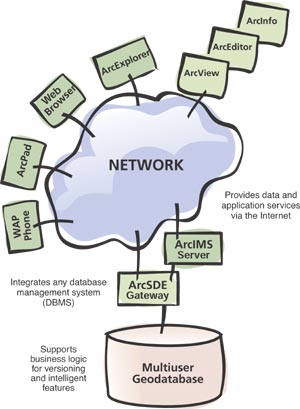 ArcGIS products are the desktop products (ArcView, ArcEditor, and ArcInfo) and associated extensions (ArcGIS 3D Analyst, ArcGIS Spatial Analyst, etc.) as well as the ArcSDE database gateway. Other products in the ArcGIS family include ArcIMS, a complete Internet GIS solution, and ArcPad, a mobile GIS.
In the last half year, Esri has been gathering feedback from the user community to help guide our upcoming development efforts. Some of the most common requests included the following:
- Implement faster, more flexible release cycle to quickly deliver key bug fixes/enhancements.
- Improve the quality and performance of the current products.
- Focus on ArcInfo user needs (topology, geoprocessing, etc.).
- Extend data model support.
- Create extensions for network analysis and surveying.
- Add tools for advanced cartography and map labeling.
- Integrate ArcGIS and ArcIMS.
- Strengthen cross-platform support.
- Extend enterprise GIS capabilities.
- Continued support for metadata and open standards.
- Provide lightweight and server-based deployments of ArcGIS.
- Extend the 3D capabilities in ArcGIS.
New Product Releases
We are planning three types of releases in the coming year: smaller, more frequent Service Packs; larger Maintenance Updates; and major releases.
Service Packs will be Web-deployable, free to all users, and designed to incrementally deliver bug fixes, performance improvements, and focused enhancements. Maintenance Updates will aggregate Service Pack updates and deliver additional new capabilities via CD distribution and will be delivered free to users who have current software maintenance agreements with Esri.
Although the content and frequency of Service Packs and Maintenance Updates will be user driven, we anticipate two to three per year in addition to major releases. More information is available online (support.esri.com).
ArcGIS Development Projects
Many of the user requests described above will be addressed in the coming year in a series of ArcGIS 8.2 releases, including:
- The needs of ArcInfo users--Some of the most important development projects will address key ArcInfo user tasks, including advanced data modeling and topology support, new geoprocessing tools for geodatabases, advanced cartography, more platform support, and the new network and survey extensions.
- Data creation and maintenance--Probably the most requested enhancement is to add full polygon topology creation and editing support in ArcGIS. An upcoming release will enhance the existing polygon topology capabilities with support for build, clean, and shared geometry editing on geodatabases within ArcEditor and ArcInfo. Other new editing capabilities will include scan digitizing and rubber sheeting, and extended linear reference support, address editing, annotation support, and transportation network maintenance.
- New, free ArcReader application--ArcReader is a new lightweight viewer for maps that have been authored using a new optional ArcMap extension (ArcReader Publisher). ArcReader will provide GIS users with a method to publish and distribute "electronic maps" locally and over networks (including the Internet). These published map documents are called MXP files. This is similar to the relationship between Adobe Acrobat Reader and Portable Document Format (PDF) documents. One major difference is that the electronic maps used by ArcReader can contain live access to geodatabases, coverages, shapefiles, ArcIMS services, and any other supported data format (see article on cover).
- Geoprocessing--A major project is to build a new set of geoprocessing commands used for database construction, modeling, and analysis. These new commands will be designed to work on all ArcGIS data types (coverages, shapefiles, geodatabases, rasters, TINs, etc.). New interfaces will be provided, including the standard dialogs forArcToolbox tools, a new ModelBuilder environment for composing geoprocessing procedures graphically, and support for open scripting environments.
- Cartography--Among the advanced capabilities being added to ArcMap are new tools for label placement, map series generation, and high-quality map printing. In addition, Esri is investigating tools for statistical/exploratory spatial data analysis, GPS integration, and further support for open Internet map services such as WMS and GML.
- Complete data model support in the geodatabase--To help users model and manage all of their spatial data in the GIS database, Esri will add support for many data types and applications in the geodatabase, including topology, network connectivity, addresses, terrain, transportation networks (along with their complex navigational properties), facilities networks (with their complex connectivity), and the storage and management of survey measurements.
- Dynamic segmentation--This project will focus on the linear referencing capabilities of ArcGIS by completing the dynamic segmentation implementation. Key features include improved route editing, display, and event geoprocessing.
- 3D GIS enhancements--A number of new capabilities are being incorporated in ArcGIS to better support 3D GIS applications. The geodatabase will be extended to store and manage continuous terrain data sets to better handle very large data volumes. New tools are being added to the ArcScene environment in ArcGIS 3D Analyst to better support 3D objects and 3D symbology. Stereo data viewing capabilities and 3D analytical operators are also being added.
- General enhancements--There will be many additional enhancements (e.g., Adobe Illustrator export, improved annotation editing, and ISO metadata support).
ArcObjects Developer Support
Planned support for ArcObjects developers includes lightweight deployments. ArcGIS is currently a great solution for developers to create large- and medium-weight embeddable custom applications. ArcGIS 8.2 will extend the developer tools to support lightweight application deployments and facilitate wider use of the ArcGIS products within organizations. Some of the new capabilities will include a set of GIS controls that can be embedded in custom applications and efficient, lightweight run-time environments for delivering ArcObjects-based applications on a range of seat types within the organization.
ArcGIS Extensions
Four new extensions are planned for release in the next year:
- ArcGIS Survey Analyst--This joint project between Esri and Leica will add support for survey measurements in the geodatabase and new COGO and survey editing tools in ArcEditor and ArcInfo. Users will be able to create and modify features using survey measurements, import data from survey instruments, and integrate surveying and geographic data in a common environment. ArcInfo users on maintenance for the ArcInfo COGO extension will automatically receive the ArcGIS Survey Analyst.
- ArcGIS Network Analyst--Transportation network functions such as optimum path, traveling salesman, and nearest facility calculations will be provided along with advanced tools for editing and managing address databases. ArcInfo NETWORK extension users on maintenance and ArcView Network Analyst extension users on maintenance will automatically receive the new ArcGIS Network Analyst.
- Maplex Extension--This extension adds the Maplex labeling engine to the ArcMap environment. This will provide high-quality automated labeling to all digital and hardcopy maps.
- Publisher Extension--With this extension, ArcGIS desktop users will be able to publish their maps as published map documents called MXP files. All MXP files can be read and used with the free ArcReader application as well as ArcMap, which lets GIS users freely share their GIS maps with anyone inside or outside of their organization.
Integrating ArcGIS and ArcIMS
A major goal in the coming year will be to deploy more ArcGIS functionality as services in ArcIMS and across a range of Windows and UNIX server platforms. Key projects include:
- The ArcIMS ArcMap Service--Many users have requested the ability to serve maps authored in ArcMap and to be able to access all geodatabase content via ArcIMS. The ArcMap Service will deliver live maps as an ArcIMS service. Esri will port this and other ArcGIS services to run on all ArcIMS platforms. Any ArcIMS client (HTML, Java, etc.) can be used.
- The ArcIMS Metadata Service--A key project due for release early next year for ArcIMS is the Metadata Service. This project will integrate the use of ArcCatalog to record and manage individual metadata records and to load these into a central metadata catalog in the DBMS. Using ArcIMS, this metadata repository can be served openly. In turn, HTML, Java, ArcGIS, or other clients can search the metadata repository, using any open search protocol (XML, Z39.50) to find data sets, services, models, maps, CAD files, and so forth. This new capability gives users the ability to build their own nodes in spatial data clearinghouses, to implement the Geography Network architecture in their organization, and to use others' clearinghouses.
Esri Platform Support
Esri has a neutral position on hardware and operating system support for its products. We try to leverage and go "with the grain" of the best available technologies. In 2001 and beyond, Esri will continue to support and leverage our users' existing platform implementations to the maximum possible extent.
ArcView 8.1 for Windows 98/Me is planned for the end of 2001 for the Windows 98/Me platform. It is a full port of ArcView 8.1 (Single and Concurrent Use licenses) and all supported ArcGIS extensions.
Also this year, Esri will be porting ArcIMS and ArcSDE to a common set of UNIX, Linux, and Windows platforms, and beginning cross-platform delivery of ArcGIS technology on UNIX. The integration of ArcGIS and ArcIMS will be delivered on UNIX and Linux as well as Windows.
Data Management
A number of key initiatives are under way:
- Performance optimization for SQL queries--Versioned geodatabase queries and reconciliation operations.
- Detached editing--The ability to check out a portion of the database, disconnect from the network, edit the data, and at a later time reconnect and post the changes to the central database.
- History management--The ability to manage feature history and feature-level metadata as part of the geodatabase data model.
- Distributed geodatabases--This upgrade will extend the geodatabase with support for mobile remote users (e.g., field-workers using checked-out versions on a laptop) and federated databases in which local nodes have partial copies of the main database (e.g., a district office that is responsible for maintaining the data in its region and needs to transfer data periodically to the central master database).
These and other development projects are under way. They will result in a series of new releases in the coming year. Comments David Maguire, Esri director of products, "Esri has a full research and development agenda for the next year. Users are great at telling us what to work on next."