
ArcView Business Analyst and ArcIMS Help Encourage Cooperation Based on Common Understanding
GIS Supports Economic Development in Southern California Communities
Economic development experts have long recognized that many Businesses prefer to locate in close proximity to similar or complementary Businesses. They share an employee base, suppliers, large customers, or even information. The computer industry of Silicon Valley; Southern California's movie industry; and even the bed-and-breakfast inns of Santa Barbara, California, are examples of successful industry clusters. Some clusters are well-known areas, while others are less obvious. In fact, sometimes even the city where a cluster is located does not know it is there.

City of Carson's biomedical industries with 100 to 249 employees.
Discovering the Clusters
The South Bay Economic Development Partnership (www.southbaypartnership.com) is a consortium of Businesses, cities, and community organizations aimed at maintaining the economic health of the region. The partnership covers 141 square miles in the southwest portion of Los Angeles County, California, acting as an information resource to its members and Businesses wishing to locate in the area. The partnership members believed there were several clusters in the South Bay area. There was no hard data to back up their belief, and it was possible there were other clusters that were less visible but no less important to the region. Data was strictly anecdotal.
Joe Aro, executive director of the partnership, approached the City of Carson's GIS group to identify the industries in the region. Carson is one of the partnership communities. The City's Business development manager, Lance Burkholder, states, "I knew we had a range of Business data because we had recently purchased Business Analyst to examine our market areas. It seemed like a natural extension to look at the broader area."
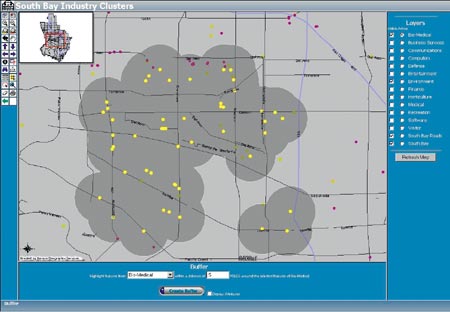
Half-mile buffers around biomedical industries near environment-related industries.
GIS staff used ArcView Business Analyst to find the industry groups the partnership requested including aerospace, finance, entertainment, medical technology, software, computers, environmental services, communication, and recreation. After creating a study area, which took only a few seconds, they extracted the desired industries. The next step was to remove the areas outside the irregular shape of the partnership communities. Because all of the City's other data was in a State Plane coordinate system, staff reprojected the ArcView Business Analyst data to match. Using an existing outline of the South Bay, they cut out the desired area in ArcView GIS and created a map for each cluster.
The maps clearly showed clusters of some of the expected clusters such as aerospace in the area of the Los Angeles Air Force Base in El Segundo. They also showed some unexpectedly strong clusters such as medical technology firms tied to the Harbor/UCLA Medical Center. The maps created more questions than they answered. Who were these Businesses? Which were small operations, and which were large companies? How were the clusters related? Answering these questions required a more dynamic solution available to all the interested parties.
ArcIMS Provides the Access
The City of Carson had been using MapObjects Internet Map Server (IMS) for some time to present property information, generate radius maps, and generate mailing labels for public notification of projects. Just as work on generating the clusters finished, ArcIMS became available. Clearly, it offered the analysis tools users wanted for the project while providing easy access to the information.
Alex Rocco, the City of Carson GIS specialist who developed the project, says, "ArcView Business Analyst provided the data, and ArcIMS provided the access. Once the ArcIMS server was connected to the data server, getting the application running was easy. We have four other applications running now as well. With the tools provided in ArcIMS, users can query the data in a variety of ways."
The application has found a number of uses. Aro says, "Using GIS for industry clusters provides an economic region's asset management. It provides accurate data by type, location, and size, all of which is of great interest to those in the clusters and people around the world doing Business with them or thinking of locating in the area. It is a great forecasting tool for local governments, helping plan for infrastructure needs. For local colleges and universities, it helps identify future workforce needs, allowing them to modify degree programs to address emerging needs. The project helps research universities identify potential research partners. For the different communities involved, the industry cluster data on the Internet encourages cooperation based on a common understanding."
With the release of the latest version of ArcView Business Analyst, Carson GIS staff looks forward to updating the cluster data and adding the new census information. The industry clusters tie in well with other GIS projects under way in South Bay to improve coordination and marketing efforts for the region. The new traffic alert program, showing traffic delays from construction, went online in April, helping to reduce congestion and improve air quality. Staff from the 15 cities of the South Bay, the California Department of Transportation, and Los Angeles County are providing data for the program and inputting it directly through this application developed by GIS Planning. A link to all of these applications can be found by clicking on the property information system on the City's Web site (ci.carson.ca.us) or at the South Bay Cities Council of Governments Web site (www.southbaycities.org).
For more information, contact Barry Waite, Carson's GIS manager (e-mail: bwaite@carson.ca.us). Also see sidebar, "Map Pads Are Handy and Useful."