Fall 2002
Fall 2002 |
|||||||
|
|
|||||||
El Paso Corporation Implements an Enterprisewide GIS |
|||||
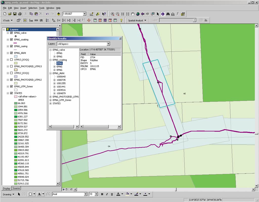
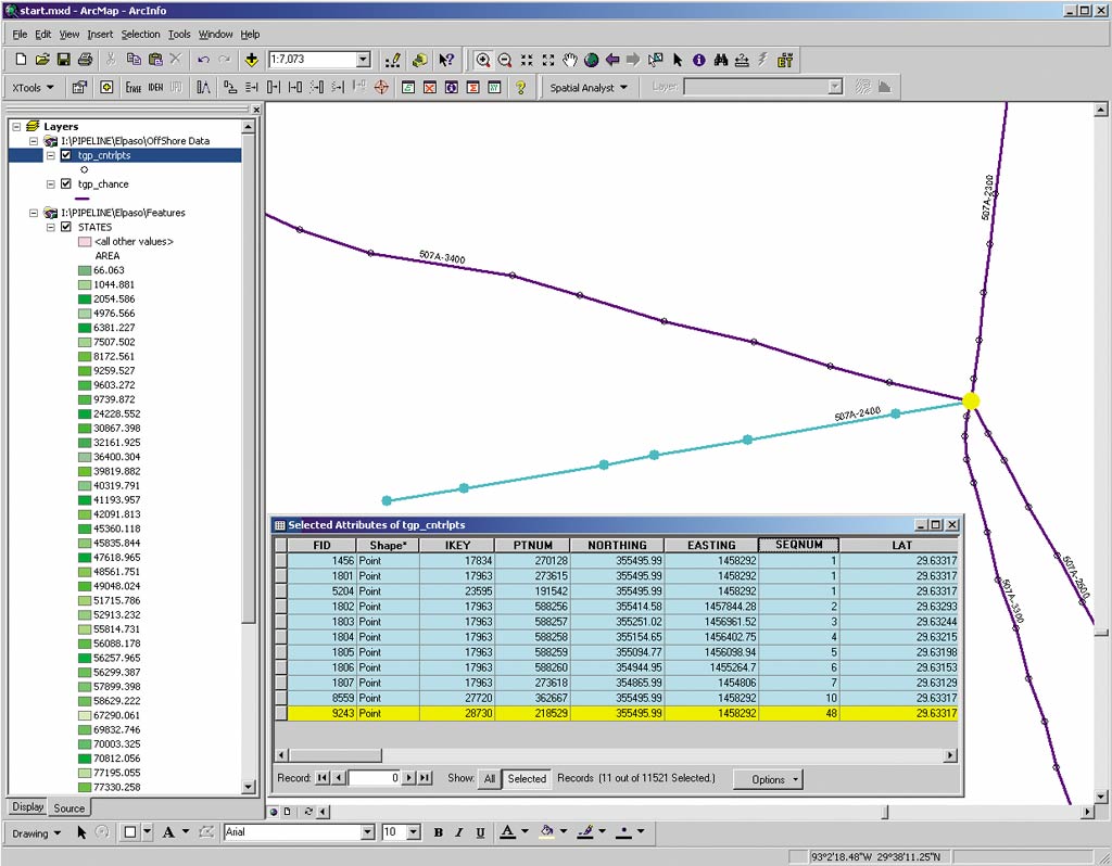
The El Paso Pipeline Group manages El Paso Corporation's network of interstate transmission pipelines spanning the United States from Canada to Mexico, from the Pacific to the Atlantic Oceans. El Paso Corporation's nationwide pipeline system is consolidated into three regional operations. The Western Pipeline Group consists of Colorado Interstate Gas Company and El Paso Natural Gas Company and is headquartered in Colorado Springs, Colorado. The Eastern Pipeline Group, consisting of ANR Pipeline Company and Tennessee Gas Pipeline Company, is headquartered in Houston, Texas. Southern Natural Gas Company is headquartered in Birmingham, Alabama. These five companies represent approximately 50,000 miles of pipelines providing natural gas transportation services from natural gas producing regions to industrial customers and local distribution companies. Adding GISWhen El Paso Corporation required a unifying GIS initiative for its interstate nationwide pipeline system, it selected M.J. Harden Associates, Inc. (MJH), an Esri Business Partner--an industry leader in pipeline transmission implementations and a leading proponent of the extended, industry-standard Integrated Spatial Analysis Techniques database model called ISAT--to perform a comprehensive system analysis. MJH was also selected for its track record implementing pipeline information systems using Esri technology. "There were no other options," says Craig Wilder, manager of Compliance Services, El Paso Energy. "MJH provided a full scope of services and had the technical Esri know-how to get things done."
MJH also performed data conversion from existing source data into the ISAT format. Esri's ArcSDE was implemented to act as the enterprise repository for all converted spatial data. "The ArcSDE environment provided the best opportunity for a successful project given the complexity of multiple projection systems, five large pipeline companies, multiple users, and a nationwide coverage," says Ed Wiegele, vice president of the MJH Pipeline Division. "Additionally, the flexibility to move between CAD and shape format seamlessly is unparalleled in the industry." MJH also enhanced its PipeView and SheetGen software to allow both CAD-based and ArcGIS software-based viewing and editing of spatial data and ISAT data stored in Microsoft's SQL Server (7.0) running ArcSDE 8.2. By employing ArcSDE, the individual Business units of El Paso Corporation can share GIS data in a common format, share database development costs, and provide a consistent database maintenance environment. This framework allows El Paso Corporation to more easily distribute strategic Business information and provides a foundation for the integration of other company units. The consolidated GIS provides El Paso Corporation with a solid platform for the creation of integrated pipeline transmission applications such as alignment sheet generation; maximum allowable operating pressure calculations; class location and high consequence area analysis; right-of-way applications; and Intranet-based data entry, query, and display capabilities all powered by data stored in ArcSDE. A Central Repository and Data InterchangeabilityThe first challenge was data interchangeability among the different pipeline companies. A common spatial data format in a universal projection was required to store the spatial data. ArcSDE allowed graphic data to be stored in geographic coordinates (latitude/longitude) in its native shapefile format. However, each pipeline system possessed a greater than 15 GB repository of orthophotography but in different coordinate systems. El Paso Corporation wanted a central repository of spatial data in a common coordinate system but was not prepared to reproject the existing photographic base. Compounding the need for custom projections was that CAD was the preferred engine for displaying and editing spatial data. MJH implemented a custom projection and data transformation tool using Esri Canada's Business Partner Safe Software Inc.'s FMEObjects Toolkit. The custom component was integrated into MJH's PipeView product to allow data stored in ArcSDE in geographic coordinates to be transformed from shapefile format to CAD format and then to be projected to the coordinate system of the underlying orthophotographic images. The second challenge was the need to maintain the ISAT database structure in conjunction with ArcSDE architecture. Transmission Pipeline Data ModelThe ISAT transmission pipeline data model was designed by a team of representatives from the following transmission pipeline companies: the Battelle Memorial Institute, the Gas Technology Institute, and MJH. The model provides support for the centerline and facilities routinely managed by a pipeline company along with some operational data required by federal regulatory agencies. Using ArcSDE to extend the ISAT model to store, manage, and distribute spatial data was an obvious choice for providing an enterprise repository for spatial data. MJH, using Esri's ArcObjects Component Library, wrote custom tools for maintaining database integrity between the ISAT and ArcSDE databases and for "data-mining" the spatial relationships between ArcSDE features. ArchitectureTo serve El Paso Corporation's Mapping and Engineering Departments for five Business units, plus consultants, the following architecture was implemented. Four servers were set up in El Paso Corporation's Houston, Texas, data center:
This architecture allows field staff and engineers to access and maintain the ISAT/ArcSDE databases from disparate and remote locations through the Citrix environment using the CAD tools familiar to them. Experienced GIS technicians can generate high-quality cartographic products and perform high-end geographic analysis on the data stored in ArcSDE using the ArcGIS software product suite. Managers, analysts, and field personnel can browse, analyze, and report on the tabular data stored in the required ISAT and ArcSDE databases using the Web-based Pipe Information Navigator applications. For more information, contact Craig Wilder, El Paso Corporation (tel.: 832-676-2525, e-mail: craig.wilder@elpaso.com), or visit www.elpaso.com, or contact Ed Wiegele, senior vice president, Pipeline Division, MJH (tel.: 816-889-1177, e-mail: ewiegele@mjharden.com) or visit www.mjharden.com. |