Fall 2002
Fall 2002 |
|||||||
|
|
|||||||
Merced, California, School District Uses GIS for Special Education School Bus Routing |
|||
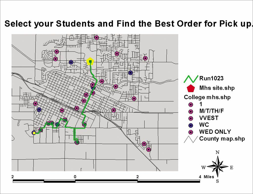
Anyone with children knows how difficult it can be to get them where they need to go, whether it's to school, little league, or ballet practice. The difficulties are compounded when there is more than one child or one of the children requires special education. Imagine trying to manage transportation for approximately 600 special needs students who attend 43 different educational facilities and 11 work sites across an 1,800-square-mile area. That is precisely the job of Merle Jewett, the director of transportation for the Merced City School District in California's Central Valley. Or more accurately stated, that is part of his job. In addition to managing the school bus routing for approximately 11,500 students in kindergarten through eighth grade in his school district, Jewett is responsible for the transportation of all the special needs students in Merced County, California. And routing special education students is a particular challenge. "Special ed transportation is probably the most difficult transportation to route because special needs students have different babysitters, they go to different houses, and every day of the week there is the possibility that the students will be riding a different bus," says Jewett. "Some of the kids visit a hospital in the morning and then go to school and get picked up there in the afternoon." Without a GIS, the transportation routing of special needs students in Merced County was a painstaking process that took weeks to accomplish. "We'd have a card on each student stacked by geographical area as well as by program," says Jewett. "We would do a lot of sorting as well as trying to put pins on a map and trying to connect dot to dot, and it would take about a month to a month and one-half of solid labor to set up the routing." Each year saw a repetition of the process. "Some students would have graduated, some would have moved, and some would have changed sites, so you have to do it all over again from scratch," Jewett adds. Jewett believed that the solution was probably to be found in GIS, but initially ran into some software and contractors who didn't offer him the flexibility he needed for his particular challenges. "We wanted a program where we could have 'hands-on' in setting up the routing for several reasons," says Jewett. "For one, medically fragile children need to go home first, even if they are the last person on the route. We needed to be able to interact with the program and do our own 'connecting dot to dot' or setting the order of students."
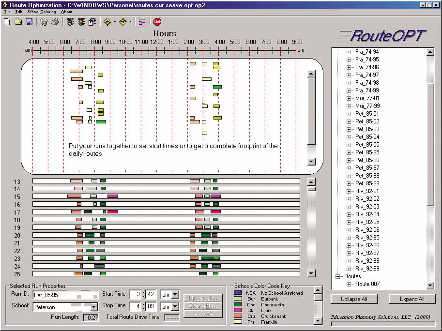
Somerville's product, SMARTR�for Schools Transportation Module, is a powerful stand-alone software system comprising ArcView, ArcView Network Analyst, and a bus manager database to more effectively manage transportation systems. "With some of the products Merle had tried, he couldn't add fields to the databases and he couldn't delete fields he didn't need," says Somerville. "He needed to be able to apply the software specifically to his district and use county GIS and other data. We could offer the solution because of the ArcView engine that was behind our software." According to Jewett, the effect of SMARTR on his planning process was immediate and dramatic. "We did it all in less than a week-for all 10 scheduling scenarios that were required for a given week. And that was just one person working with it." In addition to planning the special needs transportation, Jewett and Kathy LaSalle, the scheduler for the county and the school district, use the GIS for many of their other responsibilities. Merced City School District also uses the GIS to route more than 11,000 students to 16 different schools. The GIS helps them with their goal that the same bus driver who picks up the student is the one who drops the student off, which is easier said than done when the driver could have three routes in the morning and three in the afternoon. Building the relationships between the students and their driver in turn fosters better discipline and a safer environment on board the school bus. In addition, by using the technology to route more efficiently, the district was able to eliminate a couple of buses, leading to a direct cost savings for the taxpayer. Jewett and LaSalle also use ArcView to make school boundary adjustments, which was also a painstaking process without the use of a GIS. Jewett also finds that the GIS makes it simple to answer questions from and make presentations to the citizens' committee on redistricting and the school board. "It gets things done quicker and presents the 'what-if' scenarios better, and that's what the committee wants to see," says Jewett. Jewett is enthusiastic about the potential of GIS and is working on more ways to improve how his district does Business. When he completes his current round of bus scheduling, he wants to use the GIS to improve the district's emergency preparedness plan. "I want to embed in the map the school site layouts, where students gather in an emergency, the perimeter around the school, where the fire extinguishers are, where the gas shutoff is, you name it," Jewett says. Jewett has a message for anyone put off or intimidated by technology. "If you're computer literate at all, using ArcView and SMARTR is easy. The computer does the hard work." For more information, contact Kerry J. Somerville, EPS (tel.: 801-224-4719, e-mail: kerry@smartr.com). |