Fall 2002
Fall 2002 |
|||||||
|
|
|||||||
Associated Press and Esri Build Map Generator With ArcIMS
USA TODAY Subscribes to MapShop |
|||
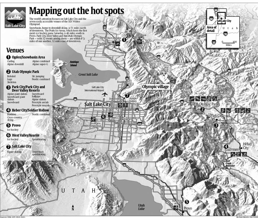
As it marked its 20th anniversary September 15, 2002, USA TODAY pointed to a legacy in print design, especially newspapers. In particular, it has influenced news cartography. Since its inception, the USA TODAY weather map--the entire country rendered in color and perspective--has been acknowledged by frequent imitation as a major advance. Less well-known, but just as influential, is its effect in popularizing thematic maps, stand-alone information graphics, and the inverted L-shaped page design that has become a Web standard. None of that matters, however, to the five million people who will read the newspaper tomorrow or the 250,000 unique daily visitors to its Web site. They also get news from rich visual media, such as TV and the Web, and from print sources that are just as sophisticated as USA TODAY in conveying visual information. Many media organizations have larger staffs with more specialists in cartography, animation, audio and video production, and rich media design. That's why USA TODAY is always seeking ways to create richer graphics without sacrificing speed or clarity. Mapping presents one of the biggest opportunities--and challenges--to compress meaning into small space so that it can still be extracted easily. With that hope, USA TODAY started testing MapShop from the Associated Press (AP) in beta form in fall 2000. The program, a browser-based map design tool, was jointly developed by Esri and the Associated Press, a newsgathering cooperative run by its 1,550 daily U.S. newspaper members. Its photos, data, and stories reach nearly a billion people a day through those newspapers; 5,000 U.S. radio and TV stations; and more than 8,500 newspaper, radio, and television subscribers in 112 countries. Esri hosts the MapShop service, which is built on ArcIMS, while the Associated Press markets it. Even in beta, MapShop was robust enough to produce a now-famous USA TODAY county-level map of the 2000 presidential election results. The red-and-blue map was published Thursday, November 9, 2000, but could have been published within hours of polls closing or every few minutes on the Web as results were fed every few minutes by the Associated Press into Esri servers hosting MapShop over that long election night. The Need for Shaded Terrain MapsNews cartography has long placed a premium on speed and clarity. This reflects the historic focus on speed in newspaper journalism, the technological limits of ink on cheap paper, and readers' expectations that information will be conveyed so clearly that it can be understood with just a glance. That emphasis has been challenged by the advent of GIS in newsrooms and the maturation of news Web sites, which allow the use of rich media and even interactive mapping. As the Afghan war began in late 2001, the prospect of U.S. forces fighting in and over Afghanistan's torturous terrain meant that USA TODAY's artists would have to produce many maps that would convey the ruggedness of the country and unified air-ground operations. At the same time, the graphics staff was gearing up to produce a series of elaborate maps and information graphics to illustrate the 2002 Olympic Games in the mountains around Salt Lake City, Utah. Both cases seemed to demand shaded terrain maps. But USA TODAY's graphics staff must produce dozens of maps, information graphics, and illustrations each day. It found shaded terrain maps so time-consuming that it tackled them only for long-term projects that were assured publication at a scale that would justify the effort. (It's not uncommon for newspaper cartographers to have the work of a day or a week scrapped because late-breaking news changes the space available for a story.) MapShop to the RescueWhile being tested, MapShop offered an immediate solution for producing shaded terrain maps quickly. Dave Merrill, the newspaper's primary cartographer, realized that MapShop offered the advantage of providing shaded terrain with georeferenced layers like streets, boundaries, and landmark points. He quickly used this for a major task at hand, producing a series of Olympic-themed maps for both the newspaper and USATODAY.com. One example: the route across rugged Wyoming terrain that Olympic medal-winning wrestler Rulon Gardner followed last winter when he became lost and so frostbitten that he eventually lost a toe. As Merrill taught other USA TODAY artists to use MapShop, they found it solved other problems. One used it to quickly produce a map to illustrate a story on Parrot Cay, a new resort in the Turks and Caicos Islands, after failing to find it from typical sources. Another used the shaded terrain feature to enrich a New Zealand map illustrating the dramatic landscapes that served as filming locales for The Lord of the Rings. USA TODAY is now a subscriber to the MapShop service. The newspaper uses MapShop about once a day on average, Merrill estimates. Two-thirds of that is for shaded terrain, but other uses are growing steadily. USATODAY.com also uses the service. Many of those uses stem from MapShop's ability to let an artist racing the clock enrich even tiny images with simple, clear details that add meaning. MapShop represents the first GIS application tuned for the unique demands of news media: speed, ease of use born of its own well-honed design, and cartographic and output flexibility. For more information, contact Paul Overberg, USA TODAY (e-mail: poverbe@usatoday.com). |