Fall 2002
Fall 2002 |
|||||||
|
|
|||||||
Providing Public Data Access and Making Use of Emergent Technology
USGS Serves Up Geospatial Data Coverages With Gapserv |
|||
|
By M.P. Mulligan and John Clark, U.S. Geological Survey Center for Biological Informatics
The gap analysis process was first conceived in the 1980s by Professor J. Michael Scott, who initiated the program with a project involving Hawaiian bird conservation. Later he and other researchers at the University of Idaho Cooperative Fish and Wildlife Research Unit launched Idaho GAP as the first pilot under cooperation with the U.S. Fish and Wildlife Service. This evolved into the GAP program, with the USGS Biological Resources Division as steward. The program has been assembling data for more than a decade. GAP data sets are geospatial data coverages at roughly 1:100,000 scale that have been assembled for each state (about 35 completed or very near completion; some now in second iteration) as part of the GAP program for the identification of gaps in potential bioreserve locations. Fundamentally, each GAP project produces three classes of spatial data products.
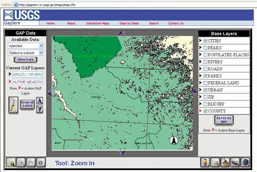
In recent years, there has been a growing understanding that a driving force behind the continued evolution of GAP will be the ability of researchers, managers, and planners to access and use the data appropriately. Ever-increasing use of the Internet among government agencies and scientific programs is creating high demand and expectations for online data retrieval. In early 2001, a team from the Denver Center for Biological Informatics (CBI); the GAP project office in Moscow, Idaho; and the USGS Reston Biological Information Office (BIO) began planning a prototype Internet map service for GAP data. The result was the Gapserv Web site (gapserv.cr.usgs.gov) to provide simple yet functional access to GAP data as a method for increasing usage of the data and spreading knowledge of the GAP program and its goals. The Gapserv concept--which was introduced and discussed at the 2001 national GAP meeting in South Dakota and the 2001 Esri International User Conference in San Diego, California--is part of ongoing mission efforts by the USGS to make biological characterization data it already holds more available via Internet technologies and simultaneously to investigate data presentation standards for the distributed information nodes in the National Biological Information Infrastructure (NBII). Gapserv was implemented to test current technology as much as to serve data. It gave the development team the opportunity to experiment and learn the capabilities of the chosen map services software. In this context, perhaps its most ambitious implementation was the employment of dynamic linkages created from the ArcSDE-Microsoft SQL data store to the ArcIMS .axl display generation. The initial project was seen as a test bed and prototype. Future evolution and enhancements will be driven by feedback from users' comments about the original effort. A three-tiered framework was identified by historical association and organizational knowledge of the probable user base: resource managers and planners, researchers such as the NBII, and the public. The Gapserv prototype includes Arc coverage of those layers of vegetation, predictive species models, land stewardship, and ownership that may, especially when coupled with other available ancillary data types, have broader application in planning and management. Some potential user communities are still unaware of its existence and the possible utility. The prototype was set up using ArcIMS 3.1, ArcSDE 8, Macromedia ColdFusion Studio 4.5, and Microsoft SQL Server 7.0. A consultation with Esri's regional office in Boulder, Colorado, ensued and the prototype plan was more fully elaborated. For the prototype, data sets were selected from four geographically distinct ecological areas: Louisiana, Montana, West Virginia, and Virginia (not yet operational). How Gapserv Works TodayGapserv users, based on the anticipated user profiles, are presented with two complementary ways to access the data:
When accessing full data sets via FTP, the user is presented with the opportunity to download various amounts of a particular state project's gap information in the formats most commonly maintained by the GAP project office. Most of this data will be delivered to the user in a .zip file format for use in the operational environment. Using the interactive mapping/GIS functionality with ArcIMS, the Gapserv prototype users are provided with several options for exploring the GAP data online:
The Future of the ProjectIt is important to note that, historically, GAP project data efforts were undertaken and independently executed by individual state cooperative projects, taking four to six years to complete, and that proceeded at varying rates and refined their methodologies and data presentation over time. Early projects were not precisely congruent with later efforts, although standard goals existed and guidelines have evolved and matured along the way. Consequently, it should be born in mind that Gapserv is still, and probably will be for some time, a work in progress, as more states' GAP projects conclude and their data is evaluated and accepted. Issues, such as the discontinuities in data of many types at state boundaries, are still being investigated by GAP. One solution that is being evaluated is to execute the next iteration of GAP in a regional framework; a first iteration of this is already underway in the southwestern United States. Gapserv also has another focus. As part of both the U.S. Department of Interior's USGS and the NBII, GAP, and therefore Gapserv, must evolve to coordinate with those larger programs and other proliferating geospatial interactive Web services. The Gapserv prototype itself may be superseded by organizational geospatial Web service sites with more data integration capacities and bigger budgets. But for USGS CBI, the experience gained with technologies such as ArcIMS and ArcSDE has only been beneficial and puts them in a position to share that experience. For general project information about Gapserv, contact Mike Mulligan (e-mail: mike_mulligan@usgs.gov). For technical information, contact John Clark (e-mail: john@usgs.gov). |
 gap: The lack of representation or underrepresentation of an element of biodiversity (plant community or animal species) in an area intended for its long-term maintenance. It is a process to keep common species common by filling in the gaps in our network of lands managed for biodiversity.