Fall 2004
Fall 2004 |
|||||||
|
|
|||||||
Open Data Consortium Proposes Geodata Portal Requirements |
|||||||
|
By Bruce Joffe, GIS Consultants, Open Data Consortium Organizer
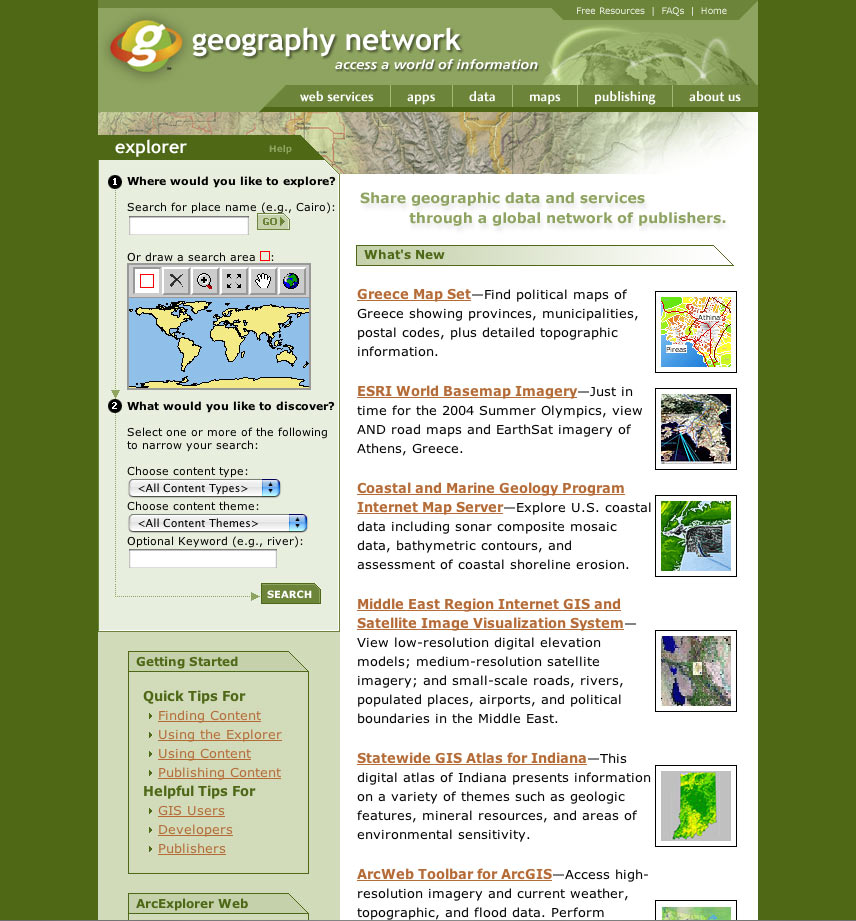
When you go to data portals, such as Geospatial One-Stop (www.geodata.gov) or the Geography Network (www.geographynetwork.com), most of the geodata reported in these catalogs is freely available to the public. Just click and download! (Figure 1 at right shows a typical geodata portal.) However, there is an even larger amount of geodata that you don't see in these catalogs: public agency geodata that is not freely available. Many local governments and utilities make their geodata available only to a limited group of users. Some make their geodata available only for a price. And some don't make their geodata available at all because they haven't yet defined their data distribution policy. Therefore, a vast amount of public geodata remains invisible; its metadata is unpublished in catalogs and data portals. Is it possible to encourage more public agencies to register their geodata in metadata catalogs? Can more public agencies be encouraged to make their data available through data portals? Perhaps the answer is "yes" if the geodata portals could handle transactions that are more complex than simply publishing for anonymous Web-based distribution. Perhaps more local governments would make their geodata available if an automated process could "negotiate" their particular data distribution requirements with each user who contacts them via a geodata portal. To move these questions toward answers, the United States Geological Survey (USGS) awarded a small grant to the GeoData Alliance (GDA—www.geoall.net) to investigate the digital rights management of geodata. GDA in turn contracted with the Open Geospatial Consortium, Inc. (OGC—www.opengeospatial.org), to assess the status of geodata digital rights and with the Open Data Consortium (ODC—www.OpenDataConsortium.org) to conceptualize the work flow and functional requirements for automating the data distribution process.
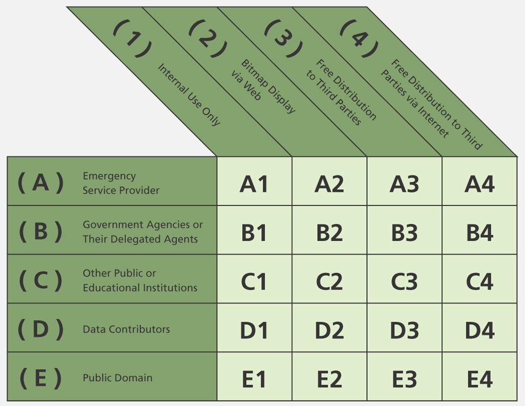
Automated data distribution must take into account the specific restrictions and requirements each public agency may have for its data, such as allowing different kinds of access to different types of users for various geodata themes and features. The variety of possible restrictions is illustrated in a simplified matrix (Figure 2), which was developed for the Bay Area Regional GIS Council's homeland security data server project (see www.BAAMA.org/bargc). As local governments contribute their geodata to this mutually beneficial emergency geodata server, they indicate which of the five user types can have access to their geodata and the type of access allowed from among the four usage categories. Automating a general purpose geodata portal would be similar although a bit more complicated. Currently, nearly every public agency has its own unique data distribution policy. However, for an automated distribution portal to "represent" each agency's individual policy, those policies would have to follow standardized data distribution requirements. Fortunately, a standardized framework for individual distribution policies has already been defined and endorsed by 117 participants who worked through the Open Data Consortium's initiative to formulate a model data distribution policy. This author organized the ODC initiative, which was supported by USGS under a separate contract. The process consisted of 24 teleconference workshops in which the participants, who often represented strongly different views about public geodata, were able to agree on a consensus-based policy. The ODC model policy provides a useful standard for automating data distribution through geodata portals because it enables a wide latitude of policy alternatives within a standardized framework. Those local governments that believe they must sell their geodata can do so in a way that is less obstructive than most agencys' current policy restrictions, while those agencies that offer their geodata for free, or simply for the cost of duplication, can also use the model policy to frame their concerns about liability, security, and privacy protection. The ODC data distribution policy model is available for inspection and comment at www.OpenDataConsortium.org.
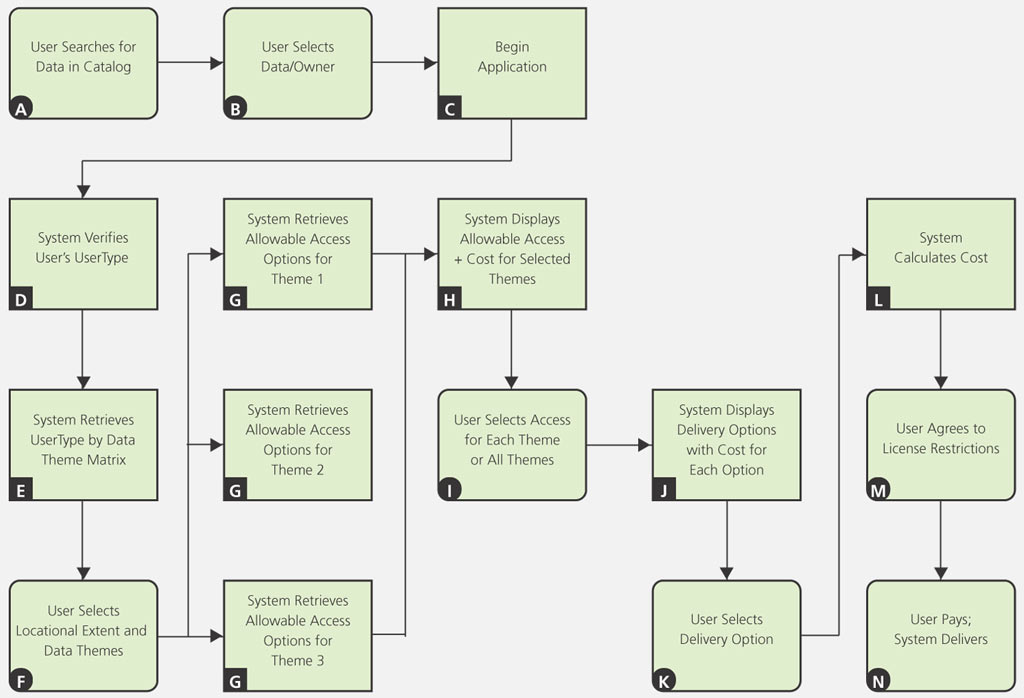
The formulation of requirements for automating a geodata distribution portal began by describing the work flow components (Figure 3). Each component represents either a user's action or the proposed system's response, starting as the user finds and selects the geodata of interest (components A and B), and then the system contacts the geodata owner's Web-based policy. The system queries the user and verifies the category of user (UserType) the person belongs to (component D). Note that the technical method for UserType verification is to be specified by OGC as part of its Digital Rights Management initiative. Each category of UserType may be allowed a specified degree of data access permission. Here is an example where data policy standardization is essential, so there are a standard number of user types to choose from. A given data owner may choose to differentiate among 12 standard categories defined in the model policy or may clump them together into three, or even two, subgroups. Each UserType is distinguished by different permissions to view or obtain an owner's geodata. Different data owners may confer different combinations of permissions to each category of user. The first "sieve" of UserType permissions that the automated portal transaction activates is the presentation of geodata themes, as well as specific map features and data attributes, that a given UserType is allowed to view or acquire (component E). The automated system does this according to a UserType by a data theme specification matrix that each data owner completes for its data. Each agency has the option of defining the degree of access it wishes to give to each type of user for each of its geodata features and attributes. The user then selects the locational extent and identifies which data themes or features to see (component F), and the system responds by presenting the user with options for accessing the geodata (component G), again following a matrix completed by the data owner. Access rights to the selected geodata may vary from only viewing the data through an application program to receiving the results of a query as a bit map image, vector map, vector map with attached data, or the entire data file or being allowed to redistribute the data. This variety of access rights may be conferred differently by each data owner to each category of user and differently for each data theme. If the owner chooses to charge a fee for the data, different fees for different degrees of access to the data, or different fees for different data features or themes, the automated transaction process will present those options to the user (component H). Finally, users select among the delivery options that are available for their UserType, ranging from simply viewing the data to receiving a digital hard copy to immediately downloading the data. Security protections are implicit because the data owner specifies whether anonymous users can download its data or whether that access is given only to verified categories of UserType. The user then pays (if necessary), and the system delivers. This requirements definition enables the flexibility necessary to engage many more local agencies in using geodata portals to distribute their data, while protecting their rights. Greater detail is in the specification paper available at the ODC Web site (www.OpenDataConsortium.org). For more information, contact Bruce Joffe, GIS Consultants (tel.: 510-238-9771, e-mail: GIS.Consultants@joffes.com). Bruce Joffe, founder of GIS Consultants in Oakland, California (www.joffes.com/GIS), provides GIS implementation planning management assistance to local governments and utilities. GIS Consultants continues to assist public agencies in developing their geodata distribution policy. |