Fall 2004
Fall 2004 |
|||||||
|
|
|||||||
Santa Cruz County, California, Converts From CAD to Geodatabase |
||
|
Santa Cruz County, California, has 255,602 residents and is situated at the northern tip of Monterey Bay, 65 miles south of San Francisco, 35 miles north of Monterey, and 35 miles southwest of the Silicon Valley. Its natural beauty is present in the pristine beaches, lush redwood forests, and rich farmland. The county has a well-established GIS dating back to the early nineties when the county implemented a mainframe GIS. The GIS provided the ability to identify changes in parcel configuration and intersect more than 60 parcel-based layers, such as city limits and special districts, to direct GIS staff to areas that needed to be realigned based on new parcel configuration. The mainframe system also produced a parcel profile table that contained a list of parcel attributes with respect to the parcel-based layers (zoning, school district, etc.).
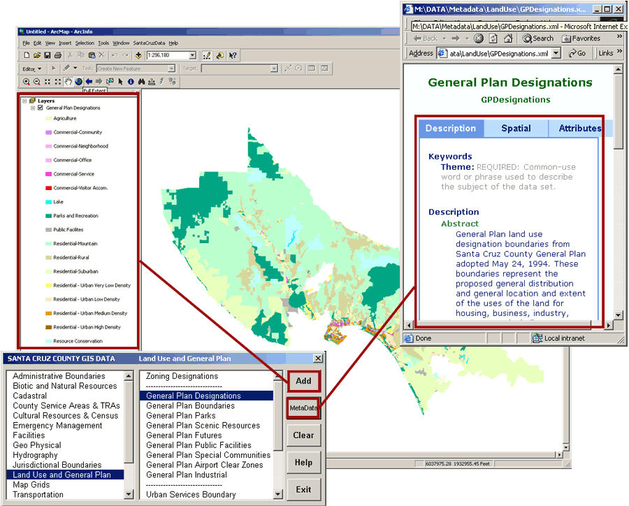
The Assessor's office was producing Assessor Map Pages in CAD and maintaining the parcel data in 102 map books (groups of Assessor Map Pages). Every two months the CAD parcel data would be compiled into files that the mainframe could read and into a countywide shapefile for the GIS users. The system supported the GIS needs of the county but placed limitations on data use and distribution and separated the assessor drafting staff from the GIS user base. In 2003, the county implemented ArcGIS Desktop (ArcInfo, ArcView, ArcEditor, ArcSDE) to support a versioned geodatabase in the Assessor's office and developed a work flow that included a version comparison program and a process to keep the parcel-based layers updated based on new parcel configurations. The parcel layer is now maintained as a countywide seamless layer, and validation of topology rules has been incorporated into the assessor's work flow. There have been support applications developed to help streamline map page creation, such as the ability to set a query definition interactively, and other tools to help with sizing and managing annotation. The benefits of the assessor staff working directly with GIS software include the ability to distribute parcel information in both polygon and line format. The polygon format is traditionally what end users would see, but as a result of the assessors doing their work in the ArcMap application of ArcGIS, enhanced parcel information is distributed to the end user. This information includes drainage and utilities easements, as well as the ability to separate out rights-of-way for cartographic display. It also provides access to labels and dimension information that was not included in the past. In addition to data distribution and cartographic benefits, changes in parcel configuration can be captured by comparing two versions, sde.default and assessors.edit. The output of this version comparison is a table that lists the old and new Assessor's Parcel Numbers (APNs) and the numbers of parcels whose boundaries have been adjusted (but number remains the same). This information is compared against APN tables for each of the more than 60 parcel-based layers. Each layer's APN table contains a list of the APNs crossed by the outline of the layer. A process was developed in ArcMap to query the version comparison table against a layer's APN table. If a match is found, the layer is loaded into ArcMap and zoomed to the location of the updated parcel configuration. The editor can then make any alignment corrections required for the layer with the APN match. Other benefits of ArcSDE have included the ability to combine GIS data from three major departments (Assessor Planning, and Public Works) into a single database to which all users have access. A data menu application was developed that provides a listing of data layers, predefined symbology, and scale references, along with access to metadata through a single interface (see figure above). Future development plans include incorporating a survey control layer for parcel corners with known GPS/State Plane coordinates to improve the spatial accuracy of the parcel layer and further integrate the Assessor's office with the surveyors. For more information, contact Matt Price, GIS manager, county of Santa Cruz (tel.: 831-454-3101, e-mail: matt.price@co.santa-cruz.co.us). |