Fall 2004
Fall 2004 |
|||||||
|
|
|||||||
To Create a Better Future
Speaking the Language of Geography—GIS
|
|
|
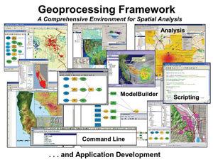
The geoprocessing framework in ArcGIS 9 provides great flexibility. The same operations, commands, and tools can be accessed using dialog boxes, run from the command line, incorporated in a visual model (e.g., ModelBuilder), or automated with the use of scripts written in a variety of scripting languages, such as Python, VBScript, and JScript. ModelBuilder is an interactive environment that provides a graphic programming framework for designing and implementing geoprocessing models. Models are data and process flow diagrams that link together tools and data.
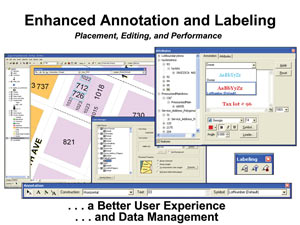
ArcGIS 9 also makes major improvements in annotation and labeling, increasing the productivity of users who create, edit, and manage labels and geodatabase annotation.
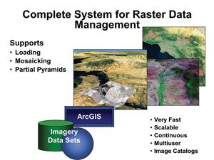
ArcGIS 9 implements a complete system for raster data management. This provides an out-of-the-box solution to store, manage, update, access, analyze, and distribute collections of aerial photographs, satellite images, digital elevation models, and other types of raster data, such as scanned documents and maps. ArcGIS 9 supports very fast loading, pyramiding, display, and mosaicking.
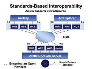
ArcGIS 9 supports standards-based interoperability by incorporating Open Geospatial Consortium standards on the server and in Esri clients. We've also integrated CAD data more closely with our GIS with zero loss of data flow. This will better support the engineering community and CAD users.
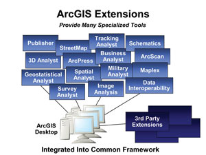
ArcGIS 9 includes many extensions, which are specialized tool sets for enriching the basic platform of particular communities.
Maplex is a specialized extension for cartographic labeling.
The ArcGIS Publisher extension has been extended at 9.0; in addition to the free ArcReader deployment, there is also a free embeddable map control. ArcGIS Publisher also includes a new data compression and protection capability for protecting data sets being used for widespread dissemination. This means that ArcGIS Publisher becomes an ideal platform for creating free CD-based applications that embed GIS functionality in a custom application and package large data sets that need to be compressed and protected (consumer products, etc.).
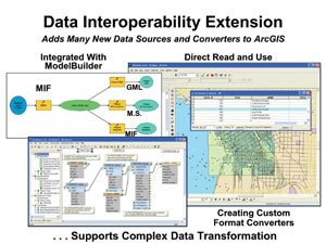
A new extension, built jointly with Esri Canada Business Partner Safe Software Inc., the world's leader in interoperability technology, is ArcGIS Data Interoperability. This extension adds many interoperability capabilities for direct reading and writing of proprietary data structures from a variety of other vendors and allows users to convert to and from standards-based formats (GML, SVTS, VPS, F57, etc.). There is also a tool in the extension that allows users to develop custom translators that can literally read any format and translate it. Interoperability is important and will become even more so as we develop GIS networks. For GIS networks to work, either everyone buys the same software and uses the same data format and data models (virtually impossible) or they use interoperability procedures and technology such as this new extension. The ArcGIS Data Interoperability extension ensures Esri users that the ArcGIS platform is and will continue to be open and interoperable with other leading GIS standards and technologies and other vendors' proprietary data types.
ArcGIS Network Analyst enhances the overall ArcGIS suite of products by adding routing, service area analysis, and the ability to create and manage network data sets. ArcGIS Network Analyst is a sophisticated visualization and analysis tool that can be used for simple or complex applications. ArcGIS Network Analyst is designed for users who need the logical network for their routing and network analysis requirements in modeling realistic network conditions and scenarios. Tools to create and manage sophisticated network data sets and to generate solutions for routing problems, such as path, tour, service area, and closest facility, are provided with the soon to be released extension.
The Server SideEsri has three server products: ArcSDE, ArcIMS, and the new ArcGIS Server. ArcSDE is a gateway to multiple DBMS systems—DB2, Informix, Oracle, and SQL Server. In this release, even though ArcSDE has always been fast, we have again improved scalability and performance. Version 9 also allows users to export an XML version/copy of the geodatabase for sharing a complete geodatabase.
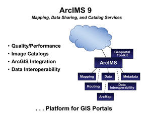
ArcIMS 9 improves quality and performance. It includes the two extensions—ArcIMS Route Server, which adds routing to your ArcIMS Web site, and ArcIMS Data Delivery, which publishes data in all the standard spatial formats used within the industry. There are also a number of enhancements. ArcIMS is a complete solution for map data and catalog publishing.
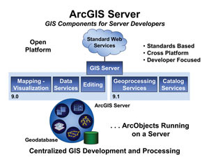
GIS Portal Toolkit, which is based on Esri's ArcIMS and ArcSDE server technology in support of the Geospatial One-Stop project, is free to students taking an Esri training class. There are more than 100 organizations that have now implemented these portals in 47 countries. Esri's newest server technology involves implementing ArcObjects in a server environment. This software, called ArcGIS Server, implements mapping, data, and editing functionality and supports a very rich and powerful developer environment. Later, we will extend ArcGIS Server with full geoprocessing and catalog services.
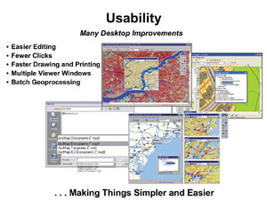
The Road AheadThe next release of ArcGIS Desktop will see more focus on making things easier. Conversely, on the server side, we are growing the basic server capability with primary focus on adding functionality, quality, and scalability. We'll also be supporting tools that facilitate more collaboration. A more usable desktop means easier editing, fewer clicks, faster draw speed, better and faster printing, and multiple viewer windows and layouts.
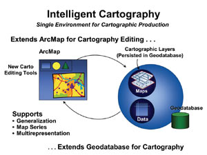
ArcGIS Desktop will also implement a new cartography concept that allows users to manage cartographics in the geodatabase. This means a collection of maps and map elements-different data frames, layers, north arrows, scale bars, etc., as well as multiple layouts that can be stored and shared across an enterprise as components for mapmaking. We're also making cartography more intelligent and providing a single environment for cartographic production. The ArcMap application is being extended for full cartographic editing, and the geodatabase is being extended to persist these rendered cartographic data sets. The human artistry of a cartographer will be integrated with computer-generated mapping. This will provide a platform to solve many problems in the areas of generalization, map series, and multiple representations.
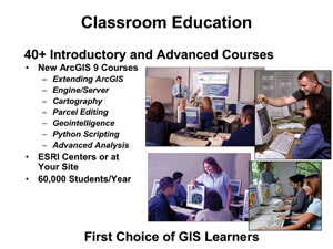
Other advancements will be in managing multidimensional data sets, dynamic modeling, and geoprocessing. A host of ArcGIS Server enhancements will include globe services, personal peer-to-peer GIS services, and serverside modeling and geoprocessing. Esri StatusEsri's goals and purpose are primarily focused on the advancement of GIS and serving our users and Business Partners around the world. Other goals include the education and development of a professional GIS workforce. While Esri is mostly a software company, we also provide education, technical support, and professional services. We are organized as a network of interoperating teams that focuses on our users. We place much emphasis on empowering smart individuals and teams within an overall organizational structure. Esri education activities focus on the development and delivery of classroom and Virtual Campus courses and various publications. We train more than 60,000 students each year in a classroom setting and more than 200,000 students via the Web. We are offering a variety of new courses that support the 9.0 release. In 2004, Esri has begun to develop "curriculum packages" by bundling our courses (both on the Web and instructor led) and providing certificates of completion. The first of these bundles ("pathways") has been released and is called GIS Analysis.
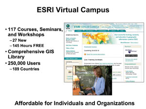
We also offer Virtual Campus training. This is an easy way for people to learn in their own time frame about the technology and some of the science and application dimensions of GIS. The Virtual Campus includes approximately 140 hours of free training. Esri has approximately one-quarter million students taking Virtual Campus courses. In 2003, we introduced Web-based live training seminars. They are one-hour sessions presented approximately twice a month and feature interactive sessions with Esri's technical staff. Subjects include GIS technology, methods, and implementation. These are free sessions and are viewable online after the training occurs. We encourage our users to look at this new method of learning.
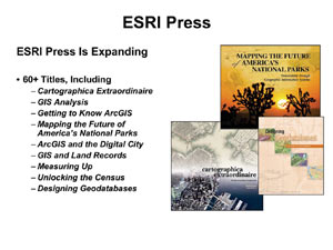
Some years ago, our users suggested we start publishing books on best practices and other aspects of GIS. Now we have more than 60 publications and another 20 on the way, authored by some of the best GIS knowledge sources in our field. New publications include Cartographica Extraordinaire, David Rumsey's new atlas of historical maps copublished with Edith Punt; Mapping the Future of America's National Parks; and Measuring Up: The Business Case for GIS. The latter book uses case studies to assess the cost/benefits of GIS implementation. A book that I would like to encourage all users to acquire is called Designing Geodatabases—for me, it is the fundamental text to understand geodatabases.
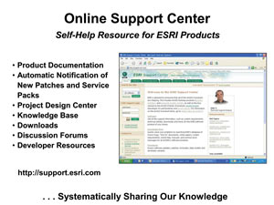
Esri technical support is improving. We've increased the knowledge of our staff and improved our own work flow for faster incident response. Our big investment, however, is in our Online Support Center (support.esri.com). Recently, we added one more component called the Project Center, which is systematically taking everything we know from an application implementation standpoint and making it available on the Web for our users.
This year, Esri is 35 years old. We are financially strong, thanks in part to our users support. We are growing. We have zero debt. We are profitable. We have a very good team of professionals at Esri (about 4,400 worldwide). They care about our users—more than 120,000 organizations and more than one million people. We have many Business Partners (more than 2,000) that also support our users in the areas of data, technology, training and consulting, system integration, and value-added software products. We take our relationships seriously and treat them with importance. They include many nongovernmental organizations, universities, and educational organizations. We also have many institutional partnerships, including the Association of American Geographers, Global Climate, National Center for Atmospheric Research, National Geographic Society, and many agencies of the United Nations. This year we've added a new one—the Jet Propulsion Laboratory (JPL)—which is focusing on using GIS for both earth and planetary sciences. This fascinates us, and we'll be working closely with them.
Imagining a Better WorldI'd like to close with a couple of comments. As important as it is to describe the actual world using GIS and geography, I think it's far more important to use GIS to imagine a better world. Languages help us define what's possible. Albert Einstein, the physicist, used the language of mathematics to define the concepts and theories of relativity, and as a result, our whole concept of the world and how it works changed. John Lennon used the language of music to set off a whole movement of thinking and humanistic behavior that also changed our global culture. Martin Luther King used spoken language to articulate the vision and the concepts of civil rights, and as a result, we saw a fundamental change in equal opportunities for all citizens. And Nelson Mandela and Jimmy Carter languaged with words the concepts and actions of human rights, and the world became a better place. GIS is a new language. It encompasses many opportunities for us to advance science, design with nature in mind, make communities livable, increase efficiency, support economic development, improve human health, and mitigate conflicts. GIS is especially well designed and suited for imagining our future. Actually, I think it's essential. Empowering geography with a language—GIS—will help us create a better future. GIS is becoming intelligent and collaborative. Connecting GIS into the societal infrastructure of the Web will lead to widespread collaboration, will bring about a better understanding, and will allow us to create a better future. GIS professionals will be the people who apply this language, creating a better future. That's how I see it. |