Fall 2004
Fall 2004 |
|||||||
|
|
|||||||
Virginia Department of Forestry Uses Internet GIS to Reach Landowners |
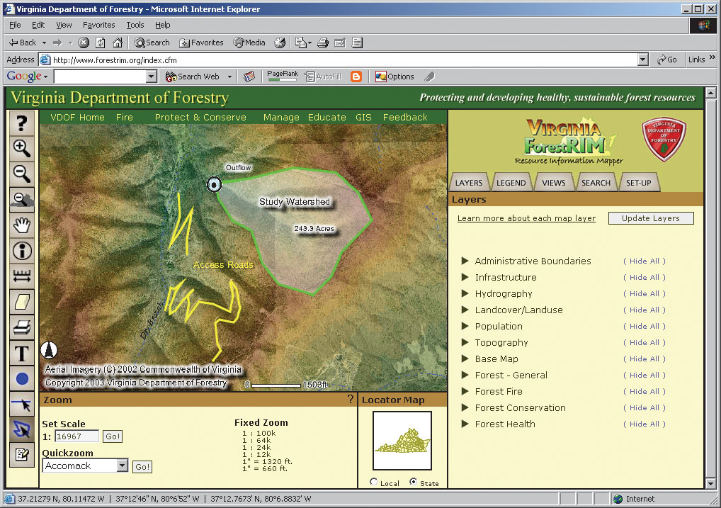
|||||
Look at a recent land cover map of the mid-Atlantic area of the United States, and you'll undoubtedly notice that Virginia has a lot of forestland. What is less obvious are the threats to this resource and the tremendous challenge the Virginia Department of Forestry (VDOF) faces in trying to reach the private landowners who ultimately determine the fate of this resource. Historically, outreach was simpler when rural forest landowners owned large blocks of land. But over time these large blocks of land have been divided into smaller and smaller pieces as people moved into rural areas. Since 1992, Virginia has lost more than 180,000 forested acres, and today private individuals own about 66 percent (10.1 million acres) of what remains. Unfortunately, these smaller forest landowners do not typically think about the trees on their property as being forestland. They are unaware of the importance of their forests and the need for good management, protection, and conservation to ensure the health of the resource as a whole. VDOF's mission to protect and develop healthy and sustainable forest resources in Virginia means the agency must teach, advise, and support all the landowners who can affect the future of Virginia's forests. As part of a plan to reach landowners, VDOF developed a two-phase approach: first, put spatial information and tools into the hands of its field employees, and second, provide that information and those tools to the public. Implementing the first phase was initially hampered because VDOF field offices, located throughout the state, are equipped with desktop computers that are not networked and use only 56K modems to reach the Internet. Despite these obstacles, VDOF wanted to use the ubiquity of the Internet to deploy a GIS that could be managed centrally and that would be easy for users to learn. Following a successful implementation for employees, VDOF would then provide spatial information and tools to its customers, such as landowners, planning commissions, forestry consultants, fire departments, and industry and conservation groups. These are users whose Internet connectivity and computer proficiency can vary widely. Insofar as the agency had already developed a robust GIS program using ArcInfo, ArcView, and ArcView Spatial Analyst, VDOF then selected Esri's ArcIMS as the backbone to develop its Forest Resource Information Mapper (ForestRIM) application. ArcIMS allowed the agency to deliver GIS data and tools via the Web, customize the functionality and user interface, and focus on users' needs. VDOF approached Terralogic, Inc., of Staunton, Virginia, which possessed substantial experience developing ArcIMS applications and was willing to push the technology to its outer limits. This was important given the significant customization VDOF desired for its application. Together, VDOF and Terralogic designed and built the application with one version for internal users and one for general public access.
ArcIMS made it possible for the agency to meet one of its key goals: to efficiently share information so that agency employees and the public at large can make better informed decisions about Virginia's forest resources. For example, visitors to the ForestRIM Web site (www.forestrim.org) can easily zoom to their location of interest, such as a single property, county, or watershed. Users choose from more than 100 map layers collected from federal, state, local, and private organizations as well as VDOF's GIS layers. The dynamic map features of ArcIMS mean that users have access to numerous map tools for navigating, identifying, measuring, and querying features. And to address the slower connection speeds, VDOF integrated AirZip Accelerator from AirZip (Cupertino, California) into the application so that users can control map speed enhancements when they need to. One unique feature of ForestRIM of benefit to Virginia employees and citizens is its Map Annotation function that gives users the ability to add their text, points, lines, and polygons over the map layers they choose from the Layers List. Acreage is automatically calculated and displayed by default when a user draws a polygon, making it an especially useful tool for VDOF's customers. Map annotations are saved for later use, for editing, or until the user deletes them. After composing a map, users can save it so at the next login the map is available for ease of renavigation or further editing, regardless from which computer they log in. For output, print formats are available in PDF, JPG, and PNG with both portrait and landscape layouts at the users' disposal. "Our mapping application has an array of functionality that helps our citizens understand the importance of Virginia's forest resource," explains Mindia Brown, GIS manager for VDOF. "Users can choose from a list of layers, including recent aerial photography, topographic maps, forest cover, wildfire risk assessment, woodland home communities, gypsy moth defoliation, and more." User feedback has been very positive. VDOF employees working one-on-one with landowners have reported that an aerial photo map of a property with recommended management activities digitized on top can help make a more convincing case to landowners. The public version of the application, released in February 2004, has also received enthusiastic responses from users. Landowners, forestry consultants, conservation groups, planning commissions, and others have logged on. For more information, visit www.forestrim.org or contact Mindia Brown, GIS manager, Virginia Department of Forestry (e-mail: Mindia.Brown@dof.virginia.gov, tel.: 434-977-6555). |