Fall 2006
Fall 2006 |
|||||||
|
|
|||||||
Managing 300,000 Acres of Prime Hardwood Timberlands at FORECON, Inc.
Empowering Forest Landowners with GIS |
|||
|
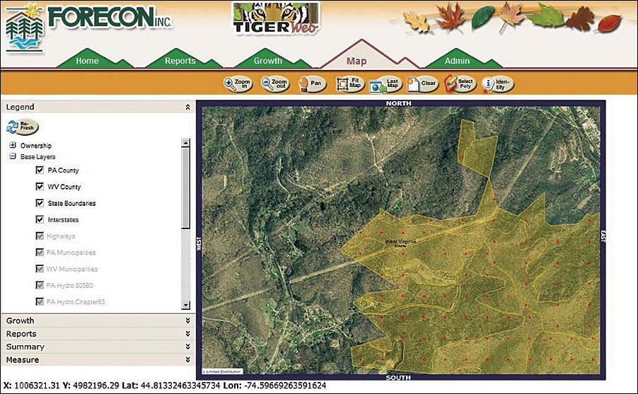
FORECON, Inc., a multidisciplinary forestry and natural resources management consulting firm headquartered in Falconer, New York, understands firsthand the complexities many of its clients—forest managers across the country—face in successfully managing large tracts of land.
Currently, the firm manages nearly 300,000 acres of prime hardwood timberlands for individuals and institutional investment groups throughout New York, Pennsylvania, and West Virginia. In working with these clients, FORECON recognizes that forestry professionals are continuously challenged to effectively manage limited natural resources in an ever-changing environment. Forest managers rely on timely and accurate inventory data to make informed business decisions that ensure the sustainability of their assets and the objectives of their ownership. However, for many forest owners, accessing and analyzing inventory data are difficult and time consuming. Often, vital stand and tract information is recorded on paper maps and stored in filing cabinets scattered among various locations. At the very least, searching, updating, and retrieving information on what may be thousands of acres of land can be challenging. Realizing the potential of GIS use for forestry applications, FORECON embarked on an extensive campaign to bring this technology to its clients, from developing mapping tools to creating a Web portal to help forest managers more efficiently view, analyze, and subsequently maximize the management of their land resources. In 2004, FORECON teamed with Esri Business Partner GeoDecisions, an information technology company specializing in geospatial solutions based in Harrisburg, Pennsylvania, to enhance its timber information management and mapping services. FORECON chose GeoDecisions to further its GIS growth based on the firm's national presence and business partnership with Esri. As a result of this relationship, FORECON can now offer its customers customized GIS tools and applications. These tools help landowners to better collect, view, analyze, and manage resource-related data. Empowering landowners to access and analyze their own data helps FORECON more easily perform everyday business functions; improve its ability to forecast the growth of its forest inventory; and, in general, develop effective management plans and budgets. FORECON chose a multiphased approach to integrating GIS into its operations and service offerings. First, GeoDecisions completed a basic needs analysis to begin building an enterprise geodatabase using ArcSDE and Microsoft SQL Server. These programs allow users to securely store a large amount of data in a single location. From there, a set of ArcInfo tools for FORECON was developed. Bundled together on a single toolbar and delivered as a custom Visual Basic .NET extension for easy access, these tools streamline FORECON's business processes and automate its cruise point generation, harvesting routine, boundary-line editing, and new client data input capabilities. For example, the Grid tool allows FORECON users to generate new cruise plots at the tract or stand level, and the Harvest tool catalogs new data more effectively. FORECON's Boundary tool accurately records changes in the stand area, and quarterly reports based on these features can be easily generated reflecting both new and older information. The Client Management tool records client data (e.g., name, address, and contact information) and uploads these datasets into the system. These diverse tools help FORECON to better classify and record inventory data. In 2005, GeoDecisions began phase three of the GIS integration—the creation of the Timber, Inventory, Growth, Evaluation, and Reporting (TIGER) desktop application. TIGER is a Visual Basic .NET desktop application that utilizes ArcObjects and FORECON's existing ArcSDE databases. The TIGER system offers a full suite of timber management tools and desktop functionality for timber growth, quarterly reporting, stand and stock tables, financial maturity modeling, and carbon market-based analysis and reporting. FORECON staff can now perform customized land management functions from their desktops. The latest client application, TIGER Web (www.tigerwebportal.net), takes the desktop application to a new level with an integrated mapping page that links to growth and reporting models. Delivered in the summer of 2006, this new, user-friendly system allows FORECON's clients to access data from any Internet-enabled location. Data previously stored in filing cabinets and formatted in paper maps is now available online in a central location, allowing any number of users to access the spatial data for current and future reporting needs and analyses. TIGER Web is one of the first solutions in the timber industry to offer owners, investors, and management specialists access to their own data through a secure, Web-based environment. Built on ArcIMS and ArcSDE frameworks, TIGER Web enables users to run customized and standardized growth models on stands, tracts, and management units, as well as generate reports in Microsoft Excel or as PDFs to view and analyze land resources. TIGER Web also allows timber owners to quickly prepare quarterly and annual reports with unprecedented accuracy. The system draws from selected data and displays it through a mapping interface so that users can easily view and analyze meaningful information. This improved access to timber data enables owners to proactively and effectively manage their resources. More InformationFor more information, contact Mike Darr, director of FORECON's GIS/Database Services (tel.: 716-664-5602, e-mail: mdarr@foreconinc.com), or Steve Ellis, vice president, GeoDecisions, a division of Gannett Fleming, Inc. (tel.: 866-426-6388, e-mail: sellis@geodecisions.com). |