Fall 2006
Fall 2006 |
|||||||
|
|
|||||||
Prince William County, Virginia, Streamlines Parcel Editing Workflow
Improving Efficiency Through Geodatabase Migration |
|||
|
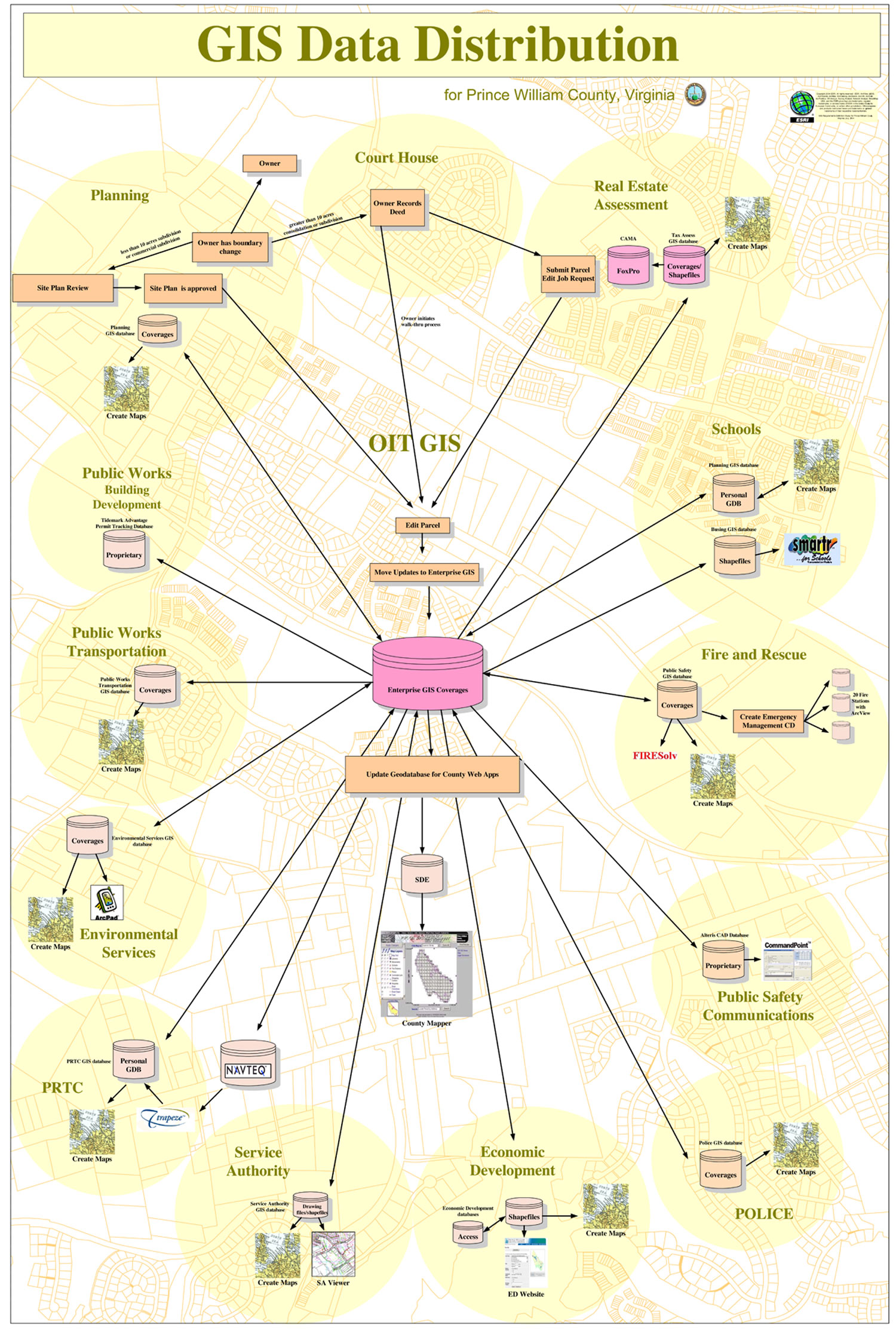
Prince William County is a rapidly growing county in northern Virginia within commuting distance of the nation's capital. The county has grown by more than 30 percent since 2000, with a With the increase of residential and commercial development in the county, the staff of the Office of Information Technology's Geographic Information Systems (OIT GIS) Division came under increasing pressure to maintain timely edits to its parcel data in the county's enterprise GIS. In addition to serving as the foundation of the county's tax base, the GIS parcel data is relied upon to support the building permit process. When subdivisions are approved and submitted for record, OIT GIS staff create the new subdivision lots in the GIS parcel layer and assign a Grid Parcel Identification Number (GPIN) to the new features. A GPIN must be assigned before a building permit can be issued by the county. As a result, any time lag in the creation of GPINs caused by a backlog of parcel edits affects customer satisfaction, as the building permit process can be delayed. The demand on staff and data infrastructure also impacted the creation and maintenance of critical county GIS datasets and applications within the areas of public safety and emergency management.
Desiring to both improve the efficiency of GIS data maintenance processes and migrate to the most current Esri GIS technology, Prince William County approached Esri's Professional Services Division in spring 2004 to discuss enhancing its GIS parcel editing capabilities and migrating from using coverages with ArcInfo to using an enterprise geodatabase with ArcInfo and ArcSDE. Specifically, the county's goals were to streamline the parcel editing process and reduce the amount of time needed by OIT GIS staff to edit parcels and produce GPINs upon subdivision approval, as well as improve data quality and accuracy of the enterprise GIS data holdings. Additionally, OIT GIS sought to provide increased access to GIS data and tools to the user community. The Professional Services staff from the Esri Washington, D.C., regional office met with OIT GIS staff and over several months developed an approach and project plan for this effort. The project plan included several phases over a one- to two-year period. The first phase of the project focused on the creation of a set of recommendations for Prince William County and included a GIS Requirements Definitions Study and a Gap Analysis of the county's existing GIS parcel editing tools. The Requirements Definitions Study served to document the GIS requirements of the county's broader GIS user community and to analyze current GIS business processes. Emphasis was placed on the GIS parcel editing process. The Gap Analysis described Prince William County's existing parcel editing process steps, making some recommendations for customizations that would add value to the routine. The GIS Requirements Definitions Study and Gap Analysis served as the foundation for the next phases of the project. The second phase of the project included defining a detailed data migration plan, developing a conceptual and logical geodatabase model using CASE tools and Microsoft Visio, and migrating the existing coverage data to a pilot geodatabase. The pilot geodatabase was used to verify that the geodatabase design would meet user needs, develop standard operating procedures for the GIS parcel data maintenance process, and design and develop customized applications recommended as part of the GAP Analysis. A use case methodology was used to design and document 12 custom applications, and both Esri and OIT GIS staff performed the application development using ArcObjects. The custom applications included a GPIN creation tool, a tool to facilitate the specific placement of feature-linked annotation, and data extraction functionality to support the creation of files necessary to load information into Prince William County's land permitting system. The third phase of the project entailed the final migration to the ArcSDE 9.x enterprise geodatabase, deployment of the customized tools, staff training, and the implementation of Job Tracking for ArcGIS (JTX). Prince William County identified training of the GIS parcel maintenance staff as critical to the overall project success and chose modified Esri instructor-led training to accomplish this. The standard Introduction to ArcGIS course was modified to include exercises built using the county's GIS data and typical tasks. Prince William County also elected to implement JTX 2.1 to assist with the tracking and management of parcel editing jobs. JTX allows OIT GIS to define parcel editing workflows, manage edit versions, and efficiently track the status of jobs. The county recently upgraded to JTX 3.0. As a result of this work, the county now possesses a more streamlined parcel editing workflow. Of the 153 steps in the 12 original use cases documented, many of the steps were removed from the workflow through automated tools and geodatabase functionality. Several of the scripts that were previously maintained by the county to aid the current parcel editing process were retired since their functionality is now included with the ArcGIS 9 products. The entire effort to streamline the parcel editing process, consisting of improved workflow, ArcGIS and JTX upgrades, database modeling and migration, and enhanced custom editing tools, has resulted in a reduction of parcel editing time and improved data quality and accuracy of the enterprise GIS data holdings. More InformationFor more information, contact Kathy Prescott, division chief, Prince William County GIS (tel.: 703-792-6847, e-mail: kprescott@pwcgov.org), or Liz Van Horn, Esri project manager (e-mail: evanhorn@esri.com). |
 current population in excess of 370,000. Prince William County is a desirable location with a highly educated workforce, nationally recognized schools, and professional business environment. The county is also rich in history and home to Civil War historic sites, such as the Manassas National Battlefield Park. Development on the county's natural and historic land reserves has increased, putting pressure on the county to support development in a manner consistent with its management and conservation goals.