Fall 2006
Fall 2006 |
|||||||
|
|
|||||||
Town of Gilbert, Arizona, Adds About 1,000 New Residents Every Month
Integrating GIS for Infrastructure Management |
|||||
|
As the fastest growing town in the United States for the last five years, Gilbert, Arizona, has quickly become a municipal behemoth. The phrase "booming metropolis" does not quite capture the phenomenon taking place in the town. In 1980, Gilbert had a population of 5,717. By 2003, this had increased by 2,300 percent to a population of more than 138,000. With a population that has almost doubled every five years since then, the southwestern town 25 miles east of Phoenix adds about 1,000 new residents every month.
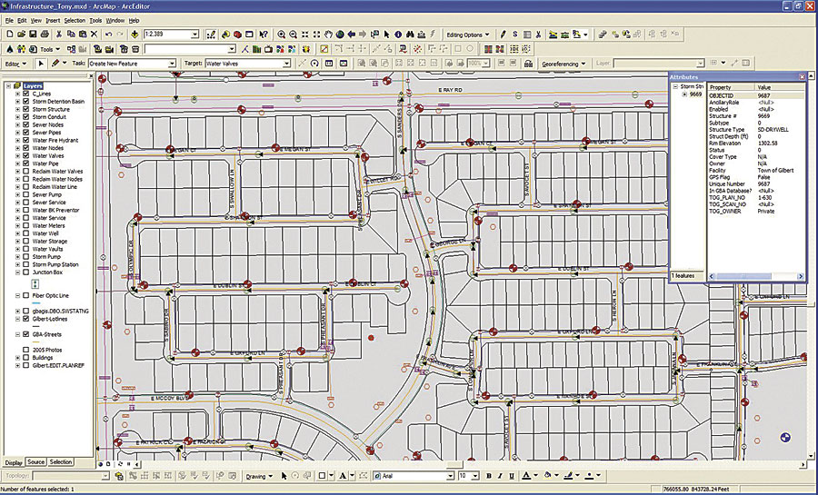
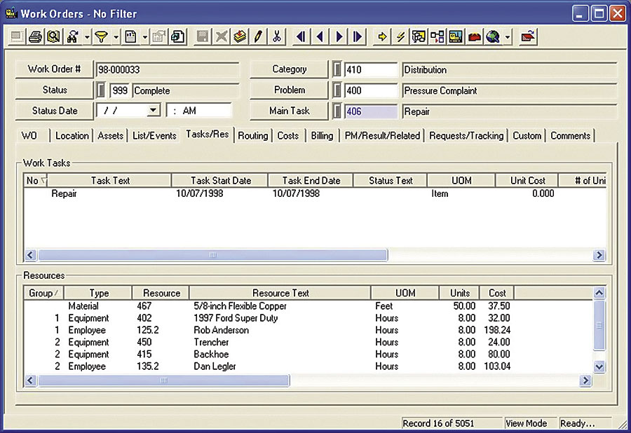
Expansion such as this creates many obstacles for a municipality. One of those obstacles is maximizing the benefits of GIS as departments develop. Ten years ago, Gilbert did not have a formal mapping system in place. Its GIS data was used primarily as a basic reference guide with little interaction. Only one person worked in the GIS Department—GIS administrator Jon Powell, whose primary responsibility was to keep land base data updated. However, with the enormous growth of the town, spatial data would play an integral part in how Gilbert functioned. As the town developed, the Public Works Department needed a GIS- integrated solution for its infrastructure management. Gilbert software analyst John Fedor says officials wanted to improve the tracking and analysis of public works costs. "The infrastructure demands were huge, and work orders were becoming more and more important with the rapid growth," Fedor says. "We needed to show where the work hours were spent and what activity we were doing, whether it was filling a pothole, repairing a main break, or something else." Eventually, tracking assets through databases was simply not enough, and the developing municipality needed to adopt software that could manage the infrastructure and integrate with GIS for spatial data and analysis. In 2002, with the GIS Department in need of assistance and the Public Works Department in need of integration, Gilbert added three positions to the GIS Department and expanded its software capabilities. Two years later, the town selected Esri Business Partner GBA Master Series' infrastructure management software as an extension to ArcGIS for use in asset management, maintenance management, and GIS-integration extensions. With the software, Gilbert would be able to track assets, create work orders, and schedule preventive maintenance. The software allowed the town to connect its infrastructure management system to GIS for data visualization, spatial analysis, map editing, and network tracing. GIS BackboneWith the newly expanded GIS Department, the town chose to implement enterprise-wide Esri solutions. Employing ArcGIS, Gilbert selected ArcInfo to edit street centerlines and edit county roads that, due to the enormous metropolis growth, were being annexed into town roads. To edit underground utilities, such as water pipes, valves, hydrants, and other sewer and storm assets, the town used ArcEditor. With the GBA Master Series-built extensions for ArcGIS in place, those who ran ArcView would be able to create, view, and edit work orders directly from the map. The integration provided by the extensions also helped by simplifying data entry.
"With regard to editing," says systems analyst Mark Kramer, "the integration allows us to keep the infrastructure management system up to date with all the latest infrastructure information, and we're not incurring any additional work because when our draftsmen make changes and save them in GIS, the extensions can update the infrastructure management system as well. That means we're really never more than a couple days, or even a couple hours, out of date at any given time with the infrastructure management system." In addition, when departments edit tabular data (such as hydrant models) in the infrastructure management system, the GIS extensions automatically update the tabular data in GIS. This increases the number of people who can contribute data to the GIS by allowing departments to add tabular data to the GIS without additional GIS staff. "This is a win-win for the town's business units and the town's GIS Department," Kramer says. "We have a project going on right now in which the Fire Department is collecting information about fire hydrants and completing a condition assessment. As the Fire Department enters the results of the field inspections into the infrastructure management system, the GIS will be updated and the GIS Department will be able to map the results of its inspections." To transmit the infrastructure management data, the town adopted ArcIMS to use as a Web-based gateway through which town departments could access the asset and work order data. The integration allows crews to jump from the infrastructure management software to a GIS map and vice versa. When crew members are viewing asset data or a work order, they can click a link that will bring up a GIS map of the specific asset to which the data relates through the ArcIMS interface. The same is true when they are viewing an asset on a GIS map; they can click a button that will take them to GBA Master Series to see associated asset data and work orders. Gilbert selected ArcSDE to connect users with spatial data within the geodatabase. Powell says, "Moving the data lets us centralize all our GIS data in one place, which really keeps it organized." The server also helped with performance, as it added speed to the town's GIS capabilities. The town also utilized ArcObjects for software components that support its GIS applications. GIS analyst Jeff Sauder used the ArcObjects tools to build a customized address application. The application provides an easy interface for non-GIS addressing technicians to create and edit spatial address information. Assistance Across the MapIn the days when Powell was the sole member of the GIS Department, he began integrating his spatial data with different departments where he saw the need, such as tying GIS to the 911 dispatch service so that the Fire Department could quickly retrieve locations and directions for emergencies and linking GIS to the Solid Waste Division for more accurate garbage truck routing. In many ways, these efforts kept Gilbert's GIS alive through the early years, giving value to the department and ensuring that GIS would not be eliminated through budget cuts. "I did my best to keep everything going and keep the organization interested in GIS," Powell says. "I wanted to make the data as accurate and valuable as possible." The hard work has paid off. Today, Powell works with four GIS technicians, one GIS analyst, and two address technicians. The staff helps maintain the infrastructure data and has begun tracking the assets that were not tracked before the department expanded. The department keeps becoming more central to the town's operations. As the GIS capabilities in the town grow, other departments are beginning to realize the full benefits that accurate spatial data can provide. Over time, the accumulated data Gilbert is collecting now through its integrated solutions will help departments pinpoint trouble areas, analyze trends, and identify where to focus maintenance efforts. "GIS is actually being integrated into almost every department's system now," Powell says. "The data is more accurate when it's integrated through GIS; it's easier to use and manipulate spatially. GIS is quickly becoming the core information system for the town." More InformationFor more information on this project, contact Jon Powell, GIS administrator, Town of Gilbert, Arizona (e-mail: jonp@ci.gilbert.az.us). |