Fall 2006
Fall 2006 |
|||||||
|
|
|||||||
GIS Aids Regional Planning in Non-Alpine Regions
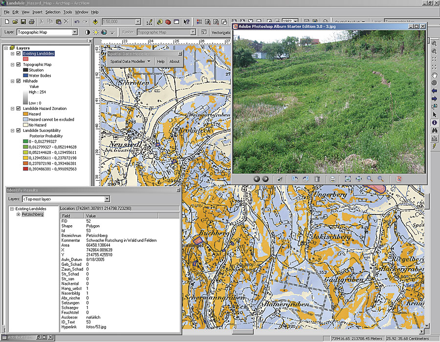
Mapping Landslide Hazards in Austria |
|||||||
|
By Bernhard Klingseisen, GIS Specialist, and Philip Leopold, Geologist, ARC Seibersdorf Research GmbH, Seibersdorf, Austria; and Maria Tschach, Chief Geologist, Federal Government of Burgenland
In the past few years, an increasing number of landslides have occurred in Burgenland, the most eastern province of Austria. Infrastructure and buildings in the southern part of the province are the most affected. Changes in the regional climate have brought heavy rainstorms, making the geological structure of Burgenland more susceptible to landslides. Together with population growth and changes in land-use policy, the potential for damage has remarkably increased as more people build their houses in potentially endangered zones, unaware of the inherent risk. Still, there is no general information on the distribution of landslides available for Burgenland, neither in the form of overview maps nor in-depth analyses of endangered sites. The government of Burgenland has funded a project, the main objective of which is the systematic collection of data on historic and recent landslide activity, as well as a comprehensive cause analysis. Based on recorded landslides and their triggering factors, the probability for future landslides is calculated with spatial statistical methods over the extent of the study area. The purpose of the resulting hazard map is the delineation of landslide risk zones to support decision makers in local and regional land-use planning. Characterizing Study Area and LandslidesThe study area comprises the districts G�ssing and Jennersdorf and covers 738 square kilometers of hilly landscape that spans the wide flat valleys through which the Pinka and Lafnitz rivers run. Pannonian klastic sediments, such as clay, silt, sand, and fine gravel, are the dominant geologic units in the region. These sediments are known for instability in cases of heavy rains, and most of the landslides are located in these zones. Partial overlays of medium to coarse gravel are suspected to stabilize the slopes. In the larger valleys, alluvial sediments accompanied by gravel terraces are found along the river banks.
Most of the project data was provided by government organizations, such as 10-meter resolution digital elevation models (DEMs), color orthophotos, and topographic maps. Geological maps were obtained from the Geological Survey of Austria at scales of 1:200,000 to 1:50,000, and data on land use was downloaded from the European Corine Landcover database. Communication with local authorities, land-use managers, and geologists, as well as an extensive literature review on geology and morphological characteristics, provided additional information on regional geology and accumulations of landslides. In summer 2005, an extensive field campaign was initiated to get a comprehensive overview of landslide damage to buildings and infrastructure. The main focus was on Active Soil Creep landslides, which are characterized by an annual movement of 1–2 centimeters. With GPS receivers and ArcPad software, the extent of landslides was digitally recorded on site together with morphological characteristics (e.g., unusually steep slopes, subsidences, neck valleys) and vegetation anomalies (e.g., bent trees). Afterward, a geodatabase was set up in ArcGIS Desktop (ArcInfo) with data on landslides and related terrain and environmental data. Predicting Landslide SusceptibilityFor the prediction of landslide susceptibility based on morphological and geological factors, the method called Weights of Evidence was chosen. It is based on the assumption that future landslides would be triggered or influenced by the same or similar controlling factors as already registered landslides. In ArcGIS Desktop, the method is accessible as part of a Natural Resources Canada (NRC) ArcGIS extension, which is freely available from www.ige.unicamp.br/sdm. In the present project, a set of five factors was analyzed for correlation with landslide events:
The layers were converted to 10-meter rasters where necessary, and several terrain parameters were derived from the DEM using ArcGIS Spatial Analyst. In the NRC extension, each of the factors was then weighted according to its relevance for the presence of landslides. Once the weighting was completed for all factors, the weights were combined to compute the probability for landslides over the whole area on a regular grid. To convert the probability map into a hazard map and make the result more helpful for decision makers, the probability values ranging from 0 to 1 were reclassified in three hazard zones (hazard, hazard cannot be excluded, and no hazard). ConclusionAfter the hazard map was presented to authorities at the Burgenland government, the work received good feedback. An area-wide mapping of landslide susceptibility had not existed before in the province, and it will now become a very useful tool for regional planning. Although local governments at the municipal level have been aware of landslide-endangered zones, a comprehensive overview of hazard zones at the district level can now help the federal government to consider landslides as a factor in the planning processes. About the AuthorsBernhard Klingseisen conducted his master's research on GIS-based landform classification at the School of Geoinformation, Carinthia Tech Institute. For the past two years, he has been extensively working on spatial analysis and Web mapping services at ARC. Philip Leopold finished his studies in engineering geology at the University of Vienna in 1999. After working in the civil engineering business, he changed to ARC focusing on hydrogeology and mass movements. After her studies of geology/paleontology at the University of Vienna, Dr. Maria Tschach has been working as chief geologist for the federal government of Burgenland. More InformationFor more information, contact Bernhard Klingseisen, GIS specialist (e-mail: bernhard. klingseisen@arcs.ac.at, tel.: 43-50550-3361), or Philip Leopold, geologist (e-mail: philip.leopold@arcs.ac.at, tel.: 43-50550-3494), ARC Seibersdorf Research GmbH, Seibersdorf, Austria, or Dr. Maria Tschach, chief geologist, federal government of Burgenland (e-mail: maria.tschach@bgld.gv.at, tel.: 43-2682-600-2080). A paper on the project was originally presented at the 2006 Esri International User Conference in the Mining and Geoscience track. The paper title is "Early Landslide Prediction in Non-Alpine Areas" by Bernhard Klingseisen and Philip Leopold. This research was funded by the federal government of Burgenland, Department of Geology. The authors also acknowledge DI Thomas Zalka from GIS Burgenland for providing the digital GIS data. |