Fall 2006
Fall 2006 |
|||||||
|
|
|||||||
GIS and Plume Modeling at the Florida Division of Forestry
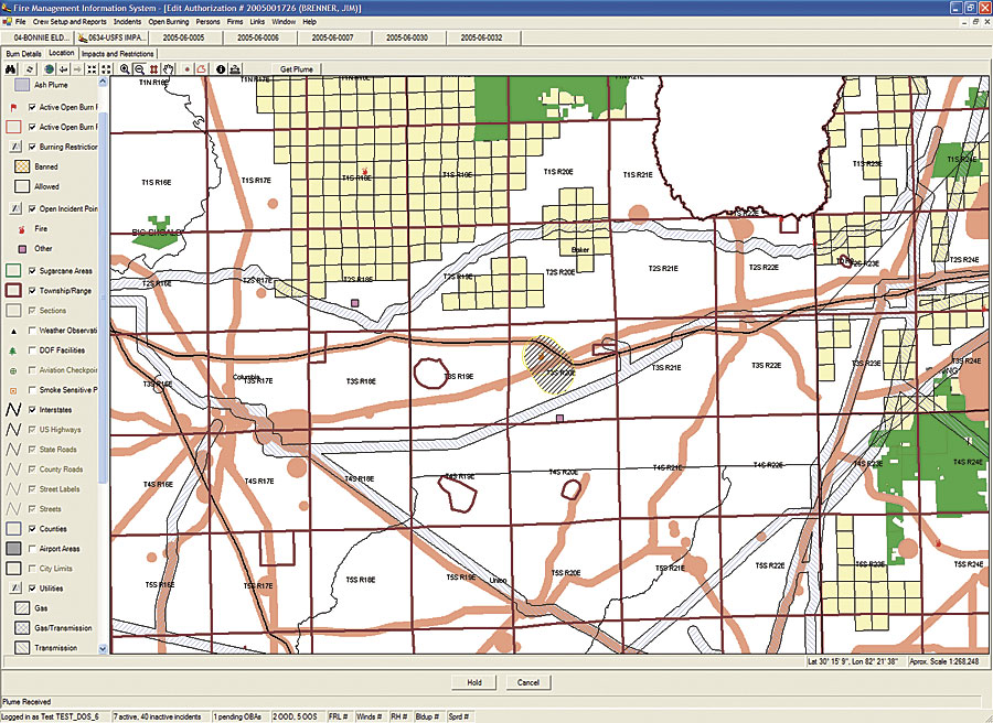
Modeling Potential Burn Hazards |
|||
|
Thinning and prescribed burning and combinations of both reduce fire range and intensity and improve forest health. If not properly managed, however, fire and the resulting smoke can have a negative impact that threatens public health and safety. GIS software is valuable for depicting plume smoke models and correlations drawn from forestry, meteorological, land base, and other pertinent information.
The Florida Division of Forestry (DOF) Fire Management Information System (FMIS) is an essential tool for effective forestry management. Information supplied to FMIS comes from the DOF's communication centers, personnel at the scene of wildfires, and state and federal agencies. GIS plays an important role in FMIS by interfacing with data from a variety of sources, spatially representing that data, and creating correlations useful to research analysis and everyday workflow tasks. The agency's relational database includes incident data about wildfires, open burning/smoke complaints, on-site inspections, illegal burns, and so forth. FMIS uses an Oracle database managed with ArcSDE. DOF uses FMIS to process data; create reports; and perform services, such as issuing open burning authorizations, responding to wildland fires and other incidents, and recording law enforcement actions taken by DOF personnel. Responding to a high demand for authorizations with sound judgment is a challenge that requires the support of an efficient system. Most requests to burn are call-ins to DOF communication centers. Duty officers issue 120,000 to 150,000 burn authorizations per year from 15 forestry offices. Approximately 80 percent of authorizations are generated between 7:00 a.m. and 9:00 a.m. On average, the duty officers have three minutes to respond to requests and provide authorizations. FMIS provides smoke plume data that the duty officer uses to assess potential visibility hazards resulting from the smoke from prescribed burns. Using hourly weather data and the Mesoscale Model number 5 (MM5) weather forecast model, a plume prediction is intersected with a GIS layer of smoke-sensitive features (e.g., roads, airports, hospitals, schools). If a plume does intersect with a feature, supervisor approval is required for releasing authorization. The smoke analysis model has continued to progress during the past decade. It now includes a component designed to track the potential impact of nuisance ash (e.g., from the burning of sugarcane fields in the southern part of the state). The model incorporates similar techniques used to study volcanic ash plumes in Hawaii and forest fires in other states. The model considers the burn request by creating trajectories that anticipate smoke layer movement at different heights in the atmosphere every hour. Along each trajectory, the perpendicular spreading of the plume is determined using a Gaussian distribution, then initial emissions are calculated. A polygon representing ground-level particle concentrations is constructed and returned to FMIS for determining intersection with layers containing smoke-sensitive features. Initial vertical velocities and terminal velocities are assigned for a representative particle; this particle is then transported in a two-dimensional (height-distance) plane using weather forecast information to determine how far along a trajectory ash is likely to travel during a time span. U.S. Department of Agriculture Forest Service meteorologist Scott Goodrick used the National Oceanic and Atmospheric Administration HySplit trajectory/dispersion model to develop the smoke plume projection component of the system as a Web service that is integrated into the FMIS application through MapObjects. Goodrick explains, "Bringing weather forecast data into the model was essential. Smoke plume modeling works in a very limited time window, and the ability to access and compute the data requires fast turnaround. The MM5 used for performing weather predictions produces gridded datasets of time-varying weather at resolutions of seven kilometers for Florida. These datasets contain wind, temperature, and atmospheric stability." When the Florida Division of Forestry receives a request for an authorization, the duty officer enters the address information into the GIS interface, which tabulates it as latitude-longitude coordinates. Based on the vegetation information in the database for that area, the model predicts how much smoke would be released by that burn and how it will move through space and time. Jim Brenner, Fire Management administrator for DOF, says, "The smoke-modeling component of FMIS supplies the Florida Division of Forestry personnel with a quick way to determine potential hazards from prescribed fires as an integrated part of its authorization process." More InformationFor more information, contact Jim Brenner, Fire Management administrator, Florida Division of Forestry (e-mail: brennej@doacs.state.fl.us), or visit the Florida Division of Forestry at www.fl-dof.com. |