Fall 2006
Fall 2006 |
|||||||
|
|
|||||||
"America's Finest City" Locates Potential Growth Areas with GIS
Smart Growth in San Diego, California |
|||
|
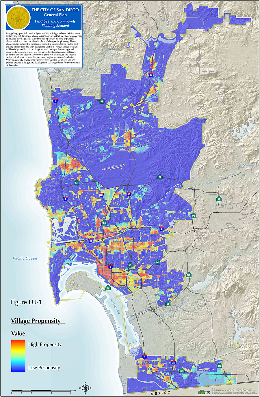
By Mike Klein, GIS Analyst, and Keith Greer, Deputy Planning Director, City of San Diego, California The City of San Diego, California, is working on updating its General Plan for the first time in more than 20 years. Since the adoption of the General Plan in 1979, the city's population has grown by 33 percent and is predicted to increase by another 35 percent to 1.65 million residents by the year 2030. Considering current growth trends, the new General Plan will need to accommodate the future housing, employment, and infrastructure needs while maintaining the quality of life expected by San Diegans.
Updating the General Plan comes at a time when the city is faced with diminishing developable land and a shortage of infrastructure funds—a scenario familiar to many large cities. The city Planning and Community Investment Department is working on future development strategies for how the city will grow. Its smart growth strategy, termed City of Villages, focuses growth inward to built communities that will become urban centers of residential use, employment, and services that are linked to and accessible via public transit. Identifying lands within the city that would satisfy all these conditions and take advantage of their relative proximity to one another was a sure task for GIS. Because city staff members were familiar with the technology, they turned to ArcGIS (ArcInfo) to identify potential "village" areas within the city utilizing the built-in tools along with the powers of ModelBuilder and the ArcGIS Spatial Analyst extension. San Diego has been termed "America's Finest City" for many reasons, including the climate, beaches and parks, and historic attractions. The new General Plan seeks to build upon the legacy to determine where and how future growth and redevelopment will occur to ensure long-term social, economic, and environmental welfare of the city and its many communities. The strategy is to focus new growth into vibrant centers of residential and commercial uses that are connected by the regional transit system. A good portion of the new growth will need to be located in urbanized areas that have the capacity for additional density. Infill development and redevelopment will play a significant role in providing housing, jobs, and services for future residents. Characteristics of these envisioned villages include pedestrian-friendly mixed-use areas that are centrally located where residential, commercial, employment, and civic uses are all present and integrated. Although such village-like areas currently exist in San Diego, the strategy is to enhance, and in some cases build upon, this village concept. Given the diversity of communities and variation of needs throughout the city, the General Plan has identified six general categories of villages that serve as a framework to the individual community plans where the specific village designations and boundaries will be identified and located. The General Plan is to include a map depicting approximate locations within the city that have the likelihood or possibility for village-like development. Previous versions of the current Draft General Plan included maps with these potential villages as generalized polygons. This approach was void of real data that could be used to support the identification of these locations. The city realized it would have to incorporate and establish more formal analysis techniques and traceable information that could be used to illustrate and support how the areas might be identified throughout the city. Subsequently, staff gathered more than 20 GIS data layers that include planned land use; transit routes and stops; schools, parks, and commercial centers; and neighborhood facilities that would be compiled as part of the analysis. The goal was to collect as many land-use datasets as possible that, when strategically combined, would reveal areas within the city that could be considered for smart growth and incorporated into the new General Plan. City staff wanted to maintain the ability to apply different weighting to the GIS layers to explore different options and alternative land-use proposals. GIS analysts from the city Planning and Community Investment Department turned to ArcGIS and explored how to best combine the data layers to reveal areas that have more or less propensity for smart growth. In general, a potential village area is one that has some or all of the following in relatively close proximity to one another: planned medium- or high-density residential public transit routes and stops, commercial uses, places of employment, and neighborhood facilities/services. Analysts worked with planners to get their input about scoring and weighting for each of the uses according to its significance or value necessary for a village-like development. Planned high-density residential and transit uses were weighted higher than high schools and parks, for example. To accommodate proximity analysis, buffers were formed to extend the area of significance around these uses to see if they were within close proximity to one another. Specifically, each input was buffered first at 1/8 mile, then at 1/4 mile. These buffer areas were then scored 3x for 1/8 mile and 2x for 1/4 mile. This buffer approach accounts for the walkability factor desired in a village. After all the inputs were weighted and buffered, the layers were converted to 75-foot raster-based datasets. ArcGIS Spatial Analyst was utilized to overlay the grid cell layers using a grid calculator. ArcGIS Spatial Analyst allows for the input scores to be mathematically combined and provides a continuous surface map eliminating the specific polygon "in or out" areas of the previous maps. The ArcGIS Spatial Analyst Reclassify tool is called upon whenever adjustments to the inputs are necessary, as the tool allows the user to simply change any grid value to another value without regenerating the grid. The final grid reveals values between 0 and 39 where higher values indicate areas that most likely support growth akin to a village. With more than 20 inputs, a lengthy analysis routine, and the expectation that staff would like the ability to modify the inputs or outputs, GIS staff used ModelBuilder to build and save the geoprocessing routines built from various tools within ArcInfo, including those available with ArcGIS Spatial Analyst. ModelBuilder allows staff to categorize geoprocessing tasks as well as assemble the order in which individual tasks are run. Currently, the entire model for the project includes 22 individual models with a total of 330 different geoprocessing tasks. Given that the update is an ongoing process that is constantly reviewed and modified until the adoption by the city council, it is absolutely imperative to have a method of analysis where individual tasks or inputs can be changed while holding a place in the model. The update of the City of San Diego General Plan comes at a time when data management and spatial analysis technology are widely utilized. Identification of community village areas, along with other smart growth policies, will help the city focus growth inward to pedestrian and transit-friendly mixed-use hubs while maintaining and improving the quality of life that residents have become familiar with. About the AuthorMike Klein works full-time as a GIS analyst with the City of San Diego in the City Planning and Community Investment Department and is also a part-time GIS instructor at Palomar Community College in San Marcos, California. More InformationFor further information, contact Mike Klein, City of San Diego (e-mail: mklein@sandiego.gov), or visit the City of San Diego General Plan Web site at www.sandiego.gov/planning/genplan/index.shtml. |