Fall 2006
Fall 2006 |
|||||||
|
|
|||||||
Delivering Geodatabase Feature-Editing with ArcGIS Server
Virginia Department of Forestry Develops Web-Based Management |
|||||
|
By Mindia Brown, Virginia Department of Forestry
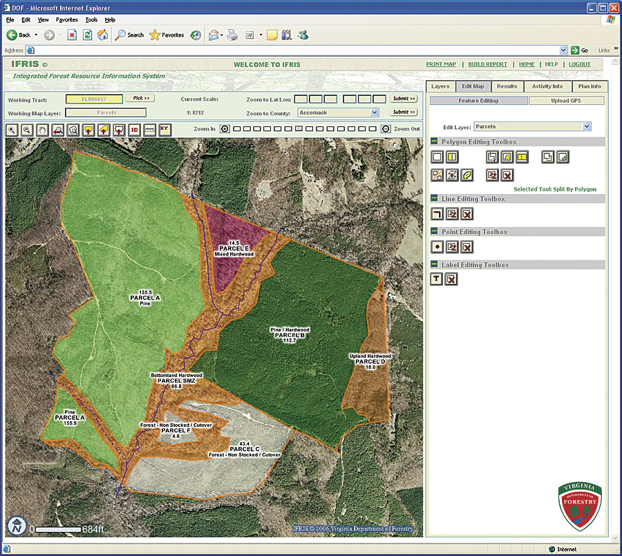
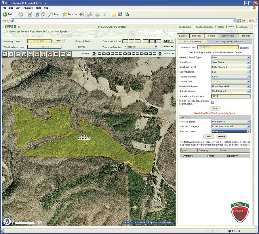
There are more than 15 million acres of forest land in Virginia that require sound management to ensure long-term protection and sustainability of this resource. To this end, the Virginia Department of Forestry (VDOF) provides private landowners with professional forest management advice and assistance in implementing practices such as aerial spraying, prescribed burning, and tree planting. It also assists landowners with cost sharing and through seedling sales. Last year alone, VDOF assisted landowners by developing management plans that covered more than 147,000 forested acres and helped renew more than 80,000 acres through tree planting. Historically, however, the agency's mechanism for tracking information about these many activities has been to input very simple data (e.g., planting—pine—50 acres) into a tabular database. Sometimes a paper map was drawn and stored at the county office in a filing cabinet as an accompaniment to the activity, but these maps were not readily available to anyone outside that office. This method has obviously limited efficiency and usefulness in terms of preserving the rich geospatial history of forest management in Virginia. Recognizing this deficiency, VDOF began developing a centralized, Web-based enterprise information system in 2004 that integrates GIS functionality to map a time series of forest management activity and forest stand conditions. This Integrated Forest Resource Information System (IFRIS) makes it possible for VDOF field staff to perform Web-based editing of geodatabases that store geometry of forest management activity areas and existing forest stand type/condition attribution. Users navigate to the property of focus and, using one-meter resolution true-color aerial photography from 2002 as a guide, map (heads-up digitize) what forest management work is being or is going to be performed. IFRIS uses Esri's ArcSDE, ArcIMS, ArcGIS Server, and Microsoft SQL Server to facilitate the creation, editing, validation, storage, and management of spatial data elements. Following intensive evaluation, VDOF contracted with the Timmons Group (an Esri Business Partner headquartered in Richmond, Virginia) for the application development, infrastructure design, and configuration. VDOF hosts the system at Virginia Information Technologies Agency (VITA) facilities. Over time, the extent, occurrence, and types of forest management activities will change. As users modify the mapped features, IFRIS preserves geospatial history through automatic archival of "parent" features and their attributes. This will enable VDOF to re-create not only the forest management activity history but also the change in forest types and conditions through time. ArcIMS is the presentation interface, but it is the ArcGIS Server integration that allows VDOF to deliver true geodatabase feature-editing tools via the IFRIS Web application. Polygon-editing tools include adding/deleting, splitting, merging, appending to, and cutting. There are also more advanced tools that include "exploding" a multipolygon feature into its component pieces, creating a "convex hull" to derive a polygon boundary from selected polygons, and creating interior (island) polygons. Basic point- and line-based editing was also developed. In addition to mapping areas that represent work performed, users have access to a library of annotation layers that they can add to, such as roads, streams, structures, and labels. And, to complement heads-up digitizing data entry, IFRIS was built to allow data captured in the field using GPS to be uploaded into IFRIS.
IFRIS was deployed for full operational use in April 2006, and VDOF expects that statewide mapping of forest management activities by its field foresters will result in a much richer dataset than the agency and its customers have ever had access to. It will enable field staff to make better assessments of how landowners should manage their resources with respect to short- and long-term goals. The mapped data will also permit regional and statewide spatial analyses relative to other spatial units, such as watersheds, stewardship priority areas, economic impact zones, and others. VDOF is poised to begin further IFRIS development to incorporate field-based mapping and data collection using Pocket PCs with integrated GPS. This technology will make it easier for field staff to capture data describing the location and nature of wildfire incidents, water-quality harvest inspections, forest health observations, and other critical data. The existing IFRIS mapping interface will then let all agency users interact with all business data for a comprehensive view of program activity. The timely, accurate, and readily available database that will evolve via IFRIS will help VDOF communicate the condition of Virginia's forests to all those who need or want to know. About the AuthorMindia Brown is the project manager for the Virginia Department of Forestry's IFRIS enterprise application development projects. More InformationFor more information, contact Mindia Brown, Virginia Department of Forestry (e-mail: Mindia.Brown@dof.virginia.gov), or Lowell Ballard, Timmons Group (e-mail: Lowell.Ballard@timmons.com). |