Highlights
- The latest field mapping capabilities increase mobile GIS productivity.
- New usability and performance enhancements make data collection faster and easier for mobile users.
- Access to GIS data and editing tools has been improved.
ArcPad 7.1 and ArcPad Application Builder 7.1, the latest versions of Esri's mobile GIS software for data collection and field mapping applications, are now available. New features and capabilities in ArcPad 7.1 increase mobile productivity by providing field-based personnel with the ability to capture, store, update, and analyze geographic information more accurately and efficiently.
| |
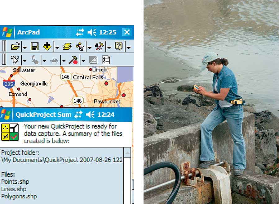
ArcPad 7.1 provides a QuickProject template, enabling users to start using ArcPad with minimal effort. |
ArcPad easily integrates with desktop and server GIS technologies, allowing field edits to be incorporated into a geodatabase through disconnected editing. Data input from GPS receivers, range finders, and digital cameras is also supported to increase reliability in the field data collection process.
ArcPad 7.1 introduces a much-anticipated, out-of-the-box solution to view and edit features and related tables in the field. The ArcPad Data Manager extension for ArcGIS Desktop makes it easier to manage mobile GIS project deployments. In addition, a new StreetMap extension is included in ArcPad 7.1 at no additional cost.
ArcPad Application Builder 7.1, the development and customization framework for ArcPad, has been improved to support ArcPad database files and custom query forms and enables users to set read-only layers. The ArcPad object model has also been updated in 7.1 to support data relationship rules and includes improved data management tools.
Key features in ArcPad 7.1 include
- Relational Database Support—ArcPad 7.1 allows users to extract geodatabase feature classes with relationships to a single ArcPad AXF file. AXF files are databases that use the Microsoft SQL Server Compact Edition database engine. Users will be able to edit the features, as well as the related tables in the field. Database rules (subtypes, coded value domains, range domains) are supported in the data and do not need to be manually added to forms.
- ArcPad Data Manager Extension for ArcGIS Desktop 9.2—The new ArcPad Data
Manager extension contains two components, an enhanced toolbar for ArcMap and newly available geoprocessing tools for ArcToolbox. This extension replaces ArcPad tools for ArcGIS that came with ArcPad 7.0 and 7.0.1. The Get Data for ArcPad tool allows users to extract data from their geodatabase and deploy it to one or multiple field devices. The Get Data from ArcPad tool enables users to check in field edits from ArcPad AXF files to quickly update their geodatabase. Users can decide if they want to password protect their data.
- StreetMap Extension—Included in core functionality to support geocoding, reverse geocoding, and routing, ArcPad 7.1 is bundled with the most recent premium street map data for the United States and Canada from Tele Atlas/TomTom at no additional cost. The StreetMap extension supports Smart Data Compression (SDC) format and provides a preconfigured basemap for users.
- QuickProject—The QuickProject template in ArcPad 7.1 helps novice and non-GIS users become immediately productive with ArcPad software. The QuickProject tool is used to create a simple data template to capture point, line, and polygon shapefiles. QuickProject creates a custom form for each shapefile, which is then used as a data capture template.
- More Powerful Query Builder to Find Features—The ArcPad Find dialog box has been updated to improve search ability. The Criteria tab has been replaced by the new Query tab. On this tab, users can search multiple fields (up to three) using different logical operators. The Results tab has also been improved to include distance and direction (from the center of the map or GPS location), which can be sorted.
- Create Custom Query Forms for Users' Feature Layers—Similar to the custom edit and identify forms created in ArcPad Studio, users can now build custom query forms for their data. Each layer can have one or more custom query forms defined, which are displayed on the Find dialog box, along with the default Query tab.
- Windows Vista Support—Both ArcPad 7.1 and ArcPad Application Builder 7.1 are compatible with Windows Vista.
ArcPad is designed for various industries and organizations wanting to expand the benefits of GIS from the office to the field. The latest enhancements in ArcPad 7.1 will help experienced users, as well as field personnel new to GIS, be more efficient and accurate when capturing field data. Together with ArcPad Application Builder, ArcPad 7.1 continues to simplify the field data collection process.
More Information
For more information or to try a fully functional evaluation copy of ArcPad, visit www.esri.com/arcpad.
|